Bahla
Koordinaten: 22° 58′ N, 57° 18′ O
Die Oasenstadt Bahla (arabisch بهلاء, DMG Bahlāʾ) ist eine der ältesten Königstädte Omans. Sie liegt etwa 180 km südlich der Hauptstadt Maskat am Fuße des Gebirges Dschabal al-Achdar. Sie ist von einer 12 km langen und 5 m hohen Stadtmauer aus Lehmziegeln umgeben. Vom 12. bis 17. Jahrhundert war Bahla Hauptstadt der Nabhani-Dynastie.
Inmitten der Stadtmauer liegt die im 17. Jahrhundert vermutlich vom Stamm der Nabhani auf einem Steinfundament mit ungebackenen Lehmziegeln und Stroh erbaute Festung Hisn Tamah. Die gewaltige Festung besitzt insgesamt 15 Tore und 132 Wehrtürme. Aufgrund ihrer Lage oberhalb des Wadis hatte sie eine große strategische Bedeutung.

Blick über Bahla


Weblinks
Commons: Bahla – Sammlung von Bildern
- Offizielle Website bezüglich Burgen und Forts. (Memento vom 5. November 2013 im Internet Archive) Omanisches Ministry of Information
- Eintrag auf der Website des Welterbezentrums der UNESCO (englisch und französisch).
Auf dieser Seite verwendete Medien

Bahla Fort in Oman 2.JPG
Autor/Urheber: Dudva, Lizenz: CC BY-SA 4.0
Bahla Fort (Arabic: قلعة بهلاء; transliterated: Qal'at Bahla') is one of four historic fortresses situated at the foot of the Djebel Akhdar highlands in Oman. It was built in the 13th and 14th centuries, when the oasis of Bahla was prosperous under the control of the Banu Nebhan tribe. The fort's ruined adobe walls and towers rise some 165 feet above its sandstone foundations. Nearby to the southwest is the Friday Mosque with a 14th-century sculpted mihrab. The fort was not restored or conserved before 1987, and had fallen into a parlous state, with parts of the walls collapsing each year in the rainy season.

Bahla Fort in Oman 1.JPG
Autor/Urheber: Dudva, Lizenz: CC BY-SA 4.0
Bahla Fort (Arabic: قلعة بهلاء; transliterated: Qal'at Bahla') is one of four historic fortresses situated at the foot of the Djebel Akhdar highlands in Oman. It was built in the 13th and 14th centuries, when the oasis of Bahla was prosperous under the control of the Banu Nebhan tribe. The fort's ruined adobe walls and towers rise some 165 feet above its sandstone foundations. Nearby to the southwest is the Friday Mosque with a 14th-century sculpted mihrab. The fort was not restored or conserved before 1987, and had fallen into a parlous state, with parts of the walls collapsing each year in the rainy season.

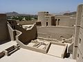
Bahla Fort in Oman 7.JPG
Autor/Urheber: Dudva, Lizenz: CC BY-SA 4.0
Bahla Fort (Arabic: قلعة بهلاء; transliterated: Qal'at Bahla') is one of four historic fortresses situated at the foot of the Djebel Akhdar highlands in Oman. It was built in the 13th and 14th centuries, when the oasis of Bahla was prosperous under the control of the Banu Nebhan tribe. The fort's ruined adobe walls and towers rise some 165 feet above its sandstone foundations. Nearby to the southwest is the Friday Mosque with a 14th-century sculpted mihrab. The fort was not restored or conserved before 1987, and had fallen into a parlous state, with parts of the walls collapsing each year in the rainy season.

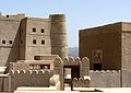
View over Bahla.jpg
Autor/Urheber: Peter, Lizenz: CC BY 2.0
A charming Omani man stopped to show a group of expat tourists where we could walk up to the roof of the Friday Mosque, with it's excellent views back over the Bahla fort and the town.
Autor/Urheber: Peter, Lizenz: CC BY 2.0
A charming Omani man stopped to show a group of expat tourists where we could walk up to the roof of the Friday Mosque, with it's excellent views back over the Bahla fort and the town.

Bahla Fort in Oman 8.JPG
Autor/Urheber: Dudva, Lizenz: CC BY-SA 4.0
Bahla Fort (Arabic: قلعة بهلاء; transliterated: Qal'at Bahla') is one of four historic fortresses situated at the foot of the Djebel Akhdar highlands in Oman. It was built in the 13th and 14th centuries, when the oasis of Bahla was prosperous under the control of the Banu Nebhan tribe. The fort's ruined adobe walls and towers rise some 165 feet above its sandstone foundations. Nearby to the southwest is the Friday Mosque with a 14th-century sculpted mihrab. The fort was not restored or conserved before 1987, and had fallen into a parlous state, with parts of the walls collapsing each year in the rainy season.

Oman adm location map.svg
(c) Karte: NordNordWest, Lizenz: Creative Commons by-sa-3.0 de
Positionskarte von Oman
(c) Karte: NordNordWest, Lizenz: Creative Commons by-sa-3.0 de
Positionskarte von Oman