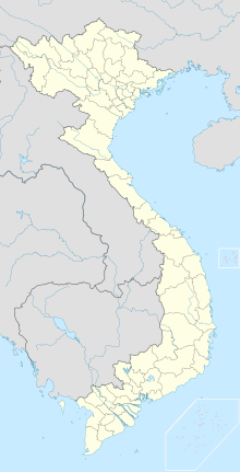
Bac-Lieu-Vogelschutzgebiet
Koordinaten: 9° 14′ 27″ N, 105° 42′ 58″ O
Das kleine Bac-Lieu-Vogelschutzgebiet liegt in Südvietnam, Provinz Bac Lieu im Mekong-Delta und hat eine Fläche von 127 Hektar.
Das Gebiet wurde 1997 in das Cac-San-Chim-Naturreservat eingefügt, welches mehrere isolierte Schutzgebiete an der Südküste in sich vereinigt.
Das sehr fruchtbare und landwirtschaftlich intensiv genutzte Reisanbaugebiet im Delta besitzt ein kleines Waldstück – letzter Rest des ursprünglichen Waldes, sowie auch saisonal überschwemmte Graslandzonen und Mangroven (Lumnitzera racemosa) kommen im Gebiet vor. Umgeben ist das Schutzgebiet von Reisfeldern, die landschaftsbestimmend für das Mekong-Delta sind. Etwa 930 Vögel der Braunwangenscharbe (Phalacrocorax fuscicollis) leben und brüten im Gebiet.
Literatur
- Buckton, S. T., Nguyen Cu, Ha Quy Quynh and Nguyen Duc Tu: The conservation of key wetland sites in the Mekong Delta. BirdLife International Vietnam Programme. Hanoi 1999.
Weblinks
Auf dieser Seite verwendete Medien
Autor/Urheber: Uwe Dedering, Lizenz: CC BY-SA 3.0
Location map of Vietnam.
Equirectangular projection. Strechted by 104 %. Geographic limits of the map:
- N: 24.0° N
- S: 8.0° N
- W: 101.8° E
- E: 110.3° E
Paracel Islands (map between). Equirectangular projection. Stretched by 52%. Geographic limits of the map:
- N: 17°15′ N
- S: 15°45′ N
- W: 111°00′ E
- E: 113°00′ E
Spratly Islands (map below). Equirectangular projection. Stretched by 41.6%. Geographic limits of the map:
- N: 12°00' N
- S: 6°12' N
- W: 111°30' E
- E: 117°20' E

