Autostrada A24
| Autostrada 24 in Italien | |||||||||||||||||||||||||||||||||||||||||||||||||||||||||||||||||||||||||||||||||||||||||||||||||||||||||||||||||||||||||||||||||||||||||||||||||||||||||||||||||||||||||||||||||||||||||||||||||||||||||||||||||||||||||||||||||||||||||||||||||||||||||||||||||||||||||||||||||||||||||||||||||||||||||||||||||||||||||||||||||||||||||||||||||||||||||||||||||||||||||||||||||||||||||||||||||||||||||||||||||||||||||||||||||||||||||||||||||||||||||||||||||||||||||||||||||||||||||||||||||||||||||||||||||||||||||||||||||||||||||||||||||||||||||||||||||||||||||||||||||||||||||||||||||||||||||||||||||||||||||||||||||||||
| Autostrada dei Parchi Roma – Teramo | |||||||||||||||||||||||||||||||||||||||||||||||||||||||||||||||||||||||||||||||||||||||||||||||||||||||||||||||||||||||||||||||||||||||||||||||||||||||||||||||||||||||||||||||||||||||||||||||||||||||||||||||||||||||||||||||||||||||||||||||||||||||||||||||||||||||||||||||||||||||||||||||||||||||||||||||||||||||||||||||||||||||||||||||||||||||||||||||||||||||||||||||||||||||||||||||||||||||||||||||||||||||||||||||||||||||||||||||||||||||||||||||||||||||||||||||||||||||||||||||||||||||||||||||||||||||||||||||||||||||||||||||||||||||||||||||||||||||||||||||||||||||||||||||||||||||||||||||||||||||||||||||||||||
 | |||||||||||||||||||||||||||||||||||||||||||||||||||||||||||||||||||||||||||||||||||||||||||||||||||||||||||||||||||||||||||||||||||||||||||||||||||||||||||||||||||||||||||||||||||||||||||||||||||||||||||||||||||||||||||||||||||||||||||||||||||||||||||||||||||||||||||||||||||||||||||||||||||||||||||||||||||||||||||||||||||||||||||||||||||||||||||||||||||||||||||||||||||||||||||||||||||||||||||||||||||||||||||||||||||||||||||||||||||||||||||||||||||||||||||||||||||||||||||||||||||||||||||||||||||||||||||||||||||||||||||||||||||||||||||||||||||||||||||||||||||||||||||||||||||||||||||||||||||||||||||||||||||||
| | |||||||||||||||||||||||||||||||||||||||||||||||||||||||||||||||||||||||||||||||||||||||||||||||||||||||||||||||||||||||||||||||||||||||||||||||||||||||||||||||||||||||||||||||||||||||||||||||||||||||||||||||||||||||||||||||||||||||||||||||||||||||||||||||||||||||||||||||||||||||||||||||||||||||||||||||||||||||||||||||||||||||||||||||||||||||||||||||||||||||||||||||||||||||||||||||||||||||||||||||||||||||||||||||||||||||||||||||||||||||||||||||||||||||||||||||||||||||||||||||||||||||||||||||||||||||||||||||||||||||||||||||||||||||||||||||||||||||||||||||||||||||||||||||||||||||||||||||||||||||||||||||||||||
| Karte | |||||||||||||||||||||||||||||||||||||||||||||||||||||||||||||||||||||||||||||||||||||||||||||||||||||||||||||||||||||||||||||||||||||||||||||||||||||||||||||||||||||||||||||||||||||||||||||||||||||||||||||||||||||||||||||||||||||||||||||||||||||||||||||||||||||||||||||||||||||||||||||||||||||||||||||||||||||||||||||||||||||||||||||||||||||||||||||||||||||||||||||||||||||||||||||||||||||||||||||||||||||||||||||||||||||||||||||||||||||||||||||||||||||||||||||||||||||||||||||||||||||||||||||||||||||||||||||||||||||||||||||||||||||||||||||||||||||||||||||||||||||||||||||||||||||||||||||||||||||||||||||||||||||
 | |||||||||||||||||||||||||||||||||||||||||||||||||||||||||||||||||||||||||||||||||||||||||||||||||||||||||||||||||||||||||||||||||||||||||||||||||||||||||||||||||||||||||||||||||||||||||||||||||||||||||||||||||||||||||||||||||||||||||||||||||||||||||||||||||||||||||||||||||||||||||||||||||||||||||||||||||||||||||||||||||||||||||||||||||||||||||||||||||||||||||||||||||||||||||||||||||||||||||||||||||||||||||||||||||||||||||||||||||||||||||||||||||||||||||||||||||||||||||||||||||||||||||||||||||||||||||||||||||||||||||||||||||||||||||||||||||||||||||||||||||||||||||||||||||||||||||||||||||||||||||||||||||||||
| Basisdaten | |||||||||||||||||||||||||||||||||||||||||||||||||||||||||||||||||||||||||||||||||||||||||||||||||||||||||||||||||||||||||||||||||||||||||||||||||||||||||||||||||||||||||||||||||||||||||||||||||||||||||||||||||||||||||||||||||||||||||||||||||||||||||||||||||||||||||||||||||||||||||||||||||||||||||||||||||||||||||||||||||||||||||||||||||||||||||||||||||||||||||||||||||||||||||||||||||||||||||||||||||||||||||||||||||||||||||||||||||||||||||||||||||||||||||||||||||||||||||||||||||||||||||||||||||||||||||||||||||||||||||||||||||||||||||||||||||||||||||||||||||||||||||||||||||||||||||||||||||||||||||||||||||||||
| Betreiber: | |||||||||||||||||||||||||||||||||||||||||||||||||||||||||||||||||||||||||||||||||||||||||||||||||||||||||||||||||||||||||||||||||||||||||||||||||||||||||||||||||||||||||||||||||||||||||||||||||||||||||||||||||||||||||||||||||||||||||||||||||||||||||||||||||||||||||||||||||||||||||||||||||||||||||||||||||||||||||||||||||||||||||||||||||||||||||||||||||||||||||||||||||||||||||||||||||||||||||||||||||||||||||||||||||||||||||||||||||||||||||||||||||||||||||||||||||||||||||||||||||||||||||||||||||||||||||||||||||||||||||||||||||||||||||||||||||||||||||||||||||||||||||||||||||||||||||||||||||||||||||||||||||||||
| Straßenbeginn: | Rom (41° 54′ 4″ N, 12° 31′ 56″ O) | ||||||||||||||||||||||||||||||||||||||||||||||||||||||||||||||||||||||||||||||||||||||||||||||||||||||||||||||||||||||||||||||||||||||||||||||||||||||||||||||||||||||||||||||||||||||||||||||||||||||||||||||||||||||||||||||||||||||||||||||||||||||||||||||||||||||||||||||||||||||||||||||||||||||||||||||||||||||||||||||||||||||||||||||||||||||||||||||||||||||||||||||||||||||||||||||||||||||||||||||||||||||||||||||||||||||||||||||||||||||||||||||||||||||||||||||||||||||||||||||||||||||||||||||||||||||||||||||||||||||||||||||||||||||||||||||||||||||||||||||||||||||||||||||||||||||||||||||||||||||||||||||||||||
| Straßenende: | Teramo (42° 40′ 3″ N, 13° 44′ 14″ O) | ||||||||||||||||||||||||||||||||||||||||||||||||||||||||||||||||||||||||||||||||||||||||||||||||||||||||||||||||||||||||||||||||||||||||||||||||||||||||||||||||||||||||||||||||||||||||||||||||||||||||||||||||||||||||||||||||||||||||||||||||||||||||||||||||||||||||||||||||||||||||||||||||||||||||||||||||||||||||||||||||||||||||||||||||||||||||||||||||||||||||||||||||||||||||||||||||||||||||||||||||||||||||||||||||||||||||||||||||||||||||||||||||||||||||||||||||||||||||||||||||||||||||||||||||||||||||||||||||||||||||||||||||||||||||||||||||||||||||||||||||||||||||||||||||||||||||||||||||||||||||||||||||||||
| Gesamtlänge: | 165,9 km | ||||||||||||||||||||||||||||||||||||||||||||||||||||||||||||||||||||||||||||||||||||||||||||||||||||||||||||||||||||||||||||||||||||||||||||||||||||||||||||||||||||||||||||||||||||||||||||||||||||||||||||||||||||||||||||||||||||||||||||||||||||||||||||||||||||||||||||||||||||||||||||||||||||||||||||||||||||||||||||||||||||||||||||||||||||||||||||||||||||||||||||||||||||||||||||||||||||||||||||||||||||||||||||||||||||||||||||||||||||||||||||||||||||||||||||||||||||||||||||||||||||||||||||||||||||||||||||||||||||||||||||||||||||||||||||||||||||||||||||||||||||||||||||||||||||||||||||||||||||||||||||||||||||
| Nutzungsvoraussetzung: | Mautpflicht: geschlossenes System auf dem Abschnitt Tivoli – Colledara Mautpflicht: offenes System auf dem Abschnitt Settecamini – Lunghezza mautfrei auf den Abschnitten Osttangente Rom – Knoten GRA und Basciano – Teramo est | ||||||||||||||||||||||||||||||||||||||||||||||||||||||||||||||||||||||||||||||||||||||||||||||||||||||||||||||||||||||||||||||||||||||||||||||||||||||||||||||||||||||||||||||||||||||||||||||||||||||||||||||||||||||||||||||||||||||||||||||||||||||||||||||||||||||||||||||||||||||||||||||||||||||||||||||||||||||||||||||||||||||||||||||||||||||||||||||||||||||||||||||||||||||||||||||||||||||||||||||||||||||||||||||||||||||||||||||||||||||||||||||||||||||||||||||||||||||||||||||||||||||||||||||||||||||||||||||||||||||||||||||||||||||||||||||||||||||||||||||||||||||||||||||||||||||||||||||||||||||||||||||||||||
| Ausbauzustand: | 2 × 2, 2 × 3, 2 × 4, 2 + 2 + 2 + 2 und 3 + 2 + 2 + 3 Fahrstreifen | ||||||||||||||||||||||||||||||||||||||||||||||||||||||||||||||||||||||||||||||||||||||||||||||||||||||||||||||||||||||||||||||||||||||||||||||||||||||||||||||||||||||||||||||||||||||||||||||||||||||||||||||||||||||||||||||||||||||||||||||||||||||||||||||||||||||||||||||||||||||||||||||||||||||||||||||||||||||||||||||||||||||||||||||||||||||||||||||||||||||||||||||||||||||||||||||||||||||||||||||||||||||||||||||||||||||||||||||||||||||||||||||||||||||||||||||||||||||||||||||||||||||||||||||||||||||||||||||||||||||||||||||||||||||||||||||||||||||||||||||||||||||||||||||||||||||||||||||||||||||||||||||||||||
(c) Ra Boe / Wikipedia, CC BY-SA 3.0 de | |||||||||||||||||||||||||||||||||||||||||||||||||||||||||||||||||||||||||||||||||||||||||||||||||||||||||||||||||||||||||||||||||||||||||||||||||||||||||||||||||||||||||||||||||||||||||||||||||||||||||||||||||||||||||||||||||||||||||||||||||||||||||||||||||||||||||||||||||||||||||||||||||||||||||||||||||||||||||||||||||||||||||||||||||||||||||||||||||||||||||||||||||||||||||||||||||||||||||||||||||||||||||||||||||||||||||||||||||||||||||||||||||||||||||||||||||||||||||||||||||||||||||||||||||||||||||||||||||||||||||||||||||||||||||||||||||||||||||||||||||||||||||||||||||||||||||||||||||||||||||||||||||||||
| Die A24 beim Knoten mit der A25 | |||||||||||||||||||||||||||||||||||||||||||||||||||||||||||||||||||||||||||||||||||||||||||||||||||||||||||||||||||||||||||||||||||||||||||||||||||||||||||||||||||||||||||||||||||||||||||||||||||||||||||||||||||||||||||||||||||||||||||||||||||||||||||||||||||||||||||||||||||||||||||||||||||||||||||||||||||||||||||||||||||||||||||||||||||||||||||||||||||||||||||||||||||||||||||||||||||||||||||||||||||||||||||||||||||||||||||||||||||||||||||||||||||||||||||||||||||||||||||||||||||||||||||||||||||||||||||||||||||||||||||||||||||||||||||||||||||||||||||||||||||||||||||||||||||||||||||||||||||||||||||||||||||||
Straßenverlauf
| |||||||||||||||||||||||||||||||||||||||||||||||||||||||||||||||||||||||||||||||||||||||||||||||||||||||||||||||||||||||||||||||||||||||||||||||||||||||||||||||||||||||||||||||||||||||||||||||||||||||||||||||||||||||||||||||||||||||||||||||||||||||||||||||||||||||||||||||||||||||||||||||||||||||||||||||||||||||||||||||||||||||||||||||||||||||||||||||||||||||||||||||||||||||||||||||||||||||||||||||||||||||||||||||||||||||||||||||||||||||||||||||||||||||||||||||||||||||||||||||||||||||||||||||||||||||||||||||||||||||||||||||||||||||||||||||||||||||||||||||||||||||||||||||||||||||||||||||||||||||||||||||||||||
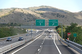
Die Autostrada A24 (italienisch für ‚Autobahn A24‘), auch Strada dei parchi genannt, ist eine italienische Autobahn und führt von Rom über L’Aquila nach Teramo und liegt in den Regionen Latium und Abruzzen. Die 165,9 km lange, mautpflichtige Straße. Seit Juli 2022 wird der gesamte Abschnitt von der staatlichen Autobahngesellschaft ANAS verwaltet.[1]
Geschichte und Ausbauzustand (in Bearbeitung)
Die Strecke ist durchgehend vierspurig ausgebaut. Der erste Abschnitt von Rom nach Castel Madama wurde 1969 für den Verkehr freigegeben, 2009 wurde der letzte Abschnitt fertiggestellt.
Eröffnungsdaten:
- Roma – Castelmadama: 10. Juli 1969
- Castelmadama – Torano: 18. Juli 1970
- Torano – L’Aquila Ovest: 14. September 1969
- L’Aquila O. – L’Aquila Est: 31. Dezember 1975
- L’Aquila Est – Assergi: 17. Oktober 1979
- Assergi – Villa Vomano: 1. Dezember 1984
- Villa Vomano – Teramo: 24. Mai 1989
Verlauf

Die Strecke verläuft durch bergiges Terrain, weshalb viele Tunnel und Brücken erbaut werden mussten.
Die A24 beginnt in Rom, wo sie von der Tangenziale Est abzweigt. Am Grande Raccordo Anulare beginnt die eigentliche Kilometrierung. Bei km 11 kreuzt sie sich mit der A1 nahe Tivoli. Weiter Richtung Osten führt sie bei Vicovaro und Castel Madama vorbei und kreuzt bei km 72 mit der A25 und in ihrem weiteren Verlauf erreicht sie die Regionshauptstadt der Abruzzen, L’Aquila.
Der mit 10.173 m längste zweiröhrige Autobahntunnel Europas, der Gran-Sasso-Tunnel, verläuft zwischen Teramo und L’Aquila. Nach 158 Kilometern erreicht die A24 den Endpunkt bei Teramo.[2]
Weblinks
- Betreiberhomepage
- Verlaufsgrafik auf aiscat.it
Einzelnachweise
Auf dieser Seite verwendete Medien
(c) OOjs UI Team and other contributors, MIT
An icon from the OOjs UI MediaWiki lib.
(Autobahn)tunnel (Icon). Gezeichnet nach dem Vorbild schweizerischer Verkehrsschilder.
Tankstellen-Piktogramm
Nach oben zeigendes schwarzes Dreieck ▲, U+25B2 aus dem Unicode-Block Geometrische Formen (25A0–25FF)
Nach unten zeigendes schwarzes Dreieck ▼, U+25BC aus dem Unicode-Block Geometrische Formen (25A0–25FF)
Wellenlinie als Gewässersymbol für die Formatvorlage Autobahn
motorway symbol with green background
Segnale di inizio autostrada (figura II 345 dell'articolo 135 del Regolamento di attuazione del Codice della Strada).
Dimensioni: larghezza 170 cm, altezza 300 cm.
end of motorway symbol, coloured in green
Icon of autostrada A90, Italy.
Icon of state road SS80racc Italy.
Nach links zeigendes schwarzes Dreieck ◀, U+25C0 aus dem Unicode-Block Geometrische Formen (25A0–25FF)
(c) Ra Boe / Wikipedia, CC BY-SA 3.0 de
Autostrada A24 Italia
Icon of autostrada A25 "Strada dei Parchi", Italy.
Segnale di inizio strada extraurbana principale (figura II 345 dell'articolo 135 del Regolamento di attuazione del Codice della Strada).
Dimensioni: larghezza 170 cm, altezza 300 cm.
Zeichen 314-50: Parken. Das Zeichen ist in den Größen 420x420, 600x600 sowie 840x840 mm erhältlich. Die Unternummer wurde im Jahr 2017 gestrichen (nun: Zeichen 314).
Flag of the Lazio Region
Icon of autostrada A1 "Autostrada del Sole", Italy.
This image is from a collection commissioned by the United States Department of Transportation and designed by AIGA. It is copyright-free, and is available here
Autobahnkreuz (Icon) in blau und grün. Vorlage entnommen aus der Straßenverkehrsordnung, eingefärbt von Christaras A. Eine große Version (in schwarz) findet sich unter Sinnbild Autobahnkreuz.svg:
Nach rechts zeigendes schwarzes Dreieck ▶, U+25B6 aus dem Unicode-Block Geometrische Formen (25A0–25FF)
A24 Motorway, Italy. Panoramic view shortly before Gran Sasso tunnel
Zeichen 391 – Mautpflichtige Strecke, StVO 2003. Farblich korrekte Umsetzung der Originalvorlage mit dem digitalen RAL-Farbton „Verkehrsrot“. Im Verkehrsblatt, Heft 24, 1976, Seite 786, wird das Zeichen „Zollstelle“, aus dem Zeichen 391 abgeleitet wurde, in seinen Details abgebildet. Die Gesamtgröße beträgt in der Regel 600 x 600 mm, in Ausnahmefälle ist eine andere Größe möglich. Die Lichtkantenbreite beträgt 10 mm, der rote Rahmen ist 24 mm breit. Die Versalhöhe beträgt bei Zeichen 391 insgesamt 100 mm. Der Ausrundungshalbmesser am linken und rechten Ende des schwarzen Balkens beträgt 50 mm.
Icon of autostrada A24 "Strada dei Parchi", Italy.
See below.
Simbolo della strada europea 80, Italia. Per la realizzazione mi sono basato sull'immagine File:Italian traffic signs - strada europea 21.svg
Autor/Urheber: User:Arbalete, Lizenz: CC BY-SA 4.0
Mappa dell’autostrada A24.
Icon of european road 45, Italy.


