Atlit-Yam

Atlit Yam ist ein untergegangenes jungsteinzeitliches Dorf vor der Küste von Atlit in Israel, das 1984 nach einem starken Sturm in Teilen freigelegt und wiederentdeckt wurde.
Hintergrund
Atlit-Yam, 200 bis 400 m vor der Küste gelegen, stellt mit 6900 bis 6300 v. Chr. den frühesten Beleg für gemischte Subsistenzwirtschaft an der levantinischen Küste dar. Die etwa 10 ha große Neolithikum-B-Siedlung liegt heute 8,0 bis 12,0 m unter dem Meeresspiegel in der Bucht von Atlit an der Mündung des Flusses Oren. In der Jungsteinzeit (Neolithikum) lag die Küstenlinie etwa einen Kilometer weiter westlich. Möglicherweise fiel die Siedlung einem vom Ätna ausgelösten Tsunami zum Opfer. Sie könnte auch bereits zuvor aufgrund der Versalzung des Brunnens aufgegeben worden sein.
Die östliche Mittelmeerküste ist geradlinig ohne Inseln oder Buchten. In der Küstenebene gibt es parallel zum Ufer mehrere Kurkar (Sandstein-Kämme). Einige sind teilweise untergetaucht und bilden etwa 150 bis 600 m vor der Küste Inseln und diskontinuierliche Riffe.
- Atlit-Yam
 (c) Hanay, CC BY-SA 3.0
Karte
 (c) Hanay, CC BY-SA 3.0
Runde Steinsetzung
 (c) Hanay, CC BY-SA 3.0
Brunnen
 (c) Hanay, CC BY-SA 3.0
Steinstruktur
 (c) Hanay, CC BY-SA 3.0
Basaltschale
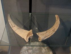 (c) Hanay, CC BY-SA 3.0
Ziegenhörner
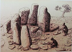 (c) Hanay, CC BY-SA 3.0
Rekonstruktion des Heiligtums
 (c) Hanay, CC BY-SA 3.0
Skelett
Die Archäologen fanden zurückgelassene Fischvorräte, was auf eine Flucht hinweisen könnte. Neben einer Reihe rechteckiger Häuser und einem Brunnen von 5,5 m Tiefe und 1,5 m Durchmesser entdeckten die Archäologen einen Halbkreis von 2,5 m Durchmesser aus sieben Megalithen, die zwischen 1,0 und 2,1 m hoch waren, um eine (mögliche) Quelle. Westlich davon lag eine Reihe von Felsplatten von 0,7 bis 1,2 m Länge. Eine weitere, offenbar rituellen Zwecken dienende Struktur fand sich in Form dreier ovaler Steine, die von Furchen umgeben waren, die schematische, anthropomorphe Figuren darstellten. An den Leichnamen einer Frau und eines Kindes entdeckte man die ältesten Spuren von Tuberkulose. Einige Männer wiesen schwere Schäden im Ohrbereich auf, was auf tödliche Tauchgänge deuten könnte. Die Tierknochen stammen von Wildtieren, doch wurden offenbar auch Getreidevorräte angelegt.
In den und um die Häuser wurden zehn Beisetzungen entdeckt. Die lithischen Funde umfassen Äxte, Pfeilspitzen und Sichelklingen.
Literatur
- Ehud Galili, Jacob Sharvi: Submerged Neolithic water-wells from the Carmel coast of Israel. In: Landschaftsverband Rheinland, Rheinisches Amt für Bodendenkmalpflege (Hrsg.): Brunnen der Jungsteinzeit. Internationales Symposium in Erkelenz, 27. bis 9. Oktober 1997 (= Materialien zur Denkmalpflege im Rheinland. Band 11). Rudolf Habelt, Bonn 1998, S. 31–44.
- Jo Marchant: Deep Secrets: Atlit-Yam, Israel. Auf: newscientist.com; abgerufen am 28. November 2009/ In: New Scientist. 25. November 2009, Band 40, Nr. 41, ISSN 0262-4079.
- Jeff Hecht: How Etna's Neolithic Hiccup Set Off a Tsunami. auf: newscientist.com abgerufen am 20. Dezember 2005/ In: New Scientist. Band 192, Nr. 2581, 9. Dezember 2006, S. 19, doi:10.1016/S0262-4079(06)61307-9
- Ehud Galili, Y. Nir: The submerged pre-pottery Neolithic water well at Atlit-Yam, northern Israel, and its palaeoenvironmental implications. In: The Holocene. Band 3, 1993, S. 265–270.
- Ker Than: Ten-Story Tsunami Thrashed Mediterranean 8,000 Years Ago. Auf: Fox News. abgerufen am 20. Dezember 2005.
Dokumentationen
- Aufgedeckt - Rätsel der Geschichte - Der Steinkreis im Mittelmeer. (Originaltitel: Ancient Mysteries.) TV-Dokumentation in HD von Jess Reid, Michael Douglas, GB 2021 für channel 5 / BBC, deutsche Synchronfassung ZDF 2021; Mitwirkende: Karen Bellinger − Anthropologin, Ehud Galili − Meeresarchäologe, Mary-Ann Ochota − Anthropologin, Clive Ruggels − Archäoastronom, Israel Hershkovitz − Anatom/ Anthropologe, Hila May − Anatomin, Rachel Sarig − Dental-Anthropologin, Anjana Khatwa − Geowissenschaftlerin.
Weblinks
Koordinaten: 32° 42′ 39″ N, 34° 56′ 6,5″ O
Auf dieser Seite verwendete Medien

(c) Hanay, CC BY-SA 3.0
Atlit Yam is an ancient submerged Neolithic village off the coast of Atlit, Israel. The site is dated to the final Pre-Pottery Neolithic B site of Atlit Yam dates between 6900 and 6300 BC. Moshe Stekelis Museum of Prehistory exhibition in Haifa Israel The exhibition is based on the excavations and researches of the Haifa University and Antiquities Authority. Photography by Yosef Galili, Ehud Galili, Itamar Greenberg
הכפר הניאוליתי בעתלית-ים שוכן בתוך הים במרחק 400 מטר מקו החוף, מערבית לשפך נחל אורן בעורפו של רכס כורכר טבוע שבהמשכו דרומה נמצא מבצר עתלית הצלבני. האתר נמצא בעומק של 12-8 מטר מתחת לפני הים. האתר מתוארך לסוף התקופה הנאוליתית קדם קרמית ב סוף האלף ה-6 לפנה"ס
ממצאים מהאתר מוצגים במוזיאון לפרהיסטוריה ע"ש משה שטקליס בחיפה הנמצא בתוך גן החיות במרכז הכרמל התערוכה מבוססת על חפירות ומחקרים שהתבצעו על ידי אוניברסיטת חיפה ורשות העתיקות הצילומים מהחפירות המוצגים בתערוכה צולמו על ידי יוסקה גלילי, אהוד גלילי ואיתמר גרינברג
מבנה פולחני שנמצא באתר – ציור המשחזר את המבנה
(c) Hanay, CC BY-SA 3.0
Atlit Yam is an ancient submerged Neolithic village off the coast of Atlit, Israel. The site is dated to the final Pre-Pottery Neolithic B site of Atlit Yam dates between 6900 and 6300 BC.
Moshe Stekelis Museum of Prehistory exhibition in Haifa Israel
The exhibition is based on the excavations and researches of the Haifa University and Antiquities Authority. Photography by Yosef Galili, Ehud Galili, Itamar Greenberg(c) Hanay, CC BY-SA 3.0
Atlit Yam is an ancient submerged Neolithic village off the coast of Atlit, Israel. The site is dated to the final Pre-Pottery Neolithic B site of Atlit Yam dates between 6900 and 6300 BC. Moshe Stekelis Museum of Prehistory exhibition in Haifa Israel The exhibition is based on the excavations and researches of the Haifa University and Antiquities Authority. Photography by Yosef Galili, Ehud Galili, Itamar Greenberg
הכפר הניאוליתי בעתלית-ים שוכן בתוך הים במרחק 400 מטר מקו החוף, מערבית לשפך נחל אורן בעורפו של רכס כורכר טבוע שבהמשכו דרומה נמצא מבצר עתלית הצלבני. האתר נמצא בעומק של 12-8 מטר מתחת לפני הים. האתר מתוארך לסוף התקופה הנאוליתית קדם קרמית ב סוף האלף ה-6 לפנה"ס
ממצאים מהאתר מוצגים במוזיאון לפרהיסטוריה ע"ש משה שטקליס בחיפה הנמצא בתוך גן החיות במרכז הכרמל התערוכה מבוססת על חפירות ומחקרים שהתבצעו על ידי אוניברסיטת חיפה ורשות העתיקות הצילומים מהחפירות המוצגים בתערוכה צולמו על ידי יוסקה גלילי, אהוד גלילי ואיתמר גרינברג
מבנה פולחני שנמצא באתר.JPG)
(c) Hanay, CC BY-SA 3.0
Atlit Yam is an ancient submerged Neolithic village off the coast of Atlit, Israel. The site is dated to the final Pre-Pottery Neolithic B site of Atlit Yam dates between 6900 and 6300 BC. Moshe Stekelis Museum of Prehistory exhibition in Haifa Israel The exhibition is based on the excavations and researches of the Haifa University and Antiquities Authority. Photography by Yosef Galili, Ehud Galili, Itamar Greenberg
הכפר הניאוליתי בעתלית-ים שוכן בתוך הים במרחק 400 מטר מקו החוף, מערבית לשפך נחל אורן בעורפו של רכס כורכר טבוע שבהמשכו דרומה נמצא מבצר עתלית הצלבני. האתר נמצא בעומק של 12-8 מטר מתחת לפני הים. האתר מתוארך לסוף התקופה הנאוליתית קדם קרמית ב סוף האלף ה-6 לפנה"ס
ממצאים מהאתר מוצגים במוזיאון לפרהיסטוריה ע"ש משה שטקליס בחיפה הנמצא בתוך גן החיות במרכז הכרמל התערוכה מבוססת על חפירות ומחקרים שהתבצעו על ידי אוניברסיטת חיפה ורשות העתיקות הצילומים מהחפירות המוצגים בתערוכה צולמו על ידי יוסקה גלילי, אהוד גלילי ואיתמר גרינברג
קערת בזלת
(c) Hanay, CC BY-SA 3.0
Atlit Yam is an ancient submerged Neolithic village off the coast of Atlit, Israel. The site is dated to the final Pre-Pottery Neolithic B site of Atlit Yam dates between 6900 and 6300 BC. Moshe Stekelis Museum of Prehistory exhibition in Haifa Israel The exhibition is based on the excavations and researches of the Haifa University and Antiquities Authority. Photography by Yosef Galili, Ehud Galili, Itamar Greenberg
הכפר הניאוליתי בעתלית-ים שוכן בתוך הים במרחק 400 מטר מקו החוף, מערבית לשפך נחל אורן בעורפו של רכס כורכר טבוע שבהמשכו דרומה נמצא מבצר עתלית הצלבני. האתר נמצא בעומק של 12-8 מטר מתחת לפני הים. האתר מתוארך לסוף התקופה הנאוליתית קדם קרמית ב סוף האלף ה-6 לפנה"ס
ממצאים מהאתר מוצגים במוזיאון לפרהיסטוריה ע"ש משה שטקליס בחיפה הנמצא בתוך גן החיות במרכז הכרמל התערוכה מבוססת על חפירות ומחקרים שהתבצעו על ידי אוניברסיטת חיפה ורשות העתיקות הצילומים מהחפירות המוצגים בתערוכה צולמו על ידי יוסקה גלילי, אהוד גלילי ואיתמר גרינברג
מפת מיקום האתרים הפרהיסטוריים המוצפים בחוף הכרמל
(c) Hanay, CC BY-SA 3.0
Atlit Yam is an ancient submerged Neolithic village off the coast of Atlit, Israel. The site is dated to the final Pre-Pottery Neolithic B site of Atlit Yam dates between 6900 and 6300 BC. Moshe Stekelis Museum of Prehistory exhibition in Haifa Israel The exhibition is based on the excavations and researches of the Haifa University and Antiquities Authority. Photography by Yosef Galili, Ehud Galili, Itamar Greenberg
הכפר הניאוליתי בעתלית-ים שוכן בתוך הים במרחק 400 מטר מקו החוף, מערבית לשפך נחל אורן בעורפו של רכס כורכר טבוע שבהמשכו דרומה נמצא מבצר עתלית הצלבני. האתר נמצא בעומק של 12-8 מטר מתחת לפני הים. האתר מתוארך לסוף התקופה הנאוליתית קדם קרמית ב סוף האלף ה-6 לפנה"ס
ממצאים מהאתר מוצגים במוזיאון לפרהיסטוריה ע"ש משה שטקליס בחיפה הנמצא בתוך גן החיות במרכז הכרמל התערוכה מבוססת על חפירות ומחקרים שהתבצעו על ידי אוניברסיטת חיפה ורשות העתיקות הצילומים מהחפירות המוצגים בתערוכה צולמו על ידי יוסקה גלילי, אהוד גלילי ואיתמר גרינברג מבנה מלבני בנוי מאבנים
מבנה מס' 13 התגלה בעומק עשרה מטרים מתחת לפני הים. המבנה בעל צורה מלבנית בגודל 6על 8 מטר. יסודותיו בנויים שני טורי אבנים שהשתמרו לגובה של שלושה נדבכים ורוחב של כ-60 ס"מ. בסמוך לקירות נחשפו שרידי ריצוף ושרידי מוקדים. מצפון למבנה נמצאו קבורות אדם. המבנה שימש כנראה למגורים
(c) Hanay, CC BY-SA 3.0
Atlit Yam is an ancient submerged Neolithic village off the coast of Atlit, Israel. The site is dated to the final Pre-Pottery Neolithic B site of Atlit Yam dates between 6900 and 6300 BC. Moshe Stekelis Museum of Prehistory exhibition in Haifa Israel The exhibition is based on the excavations and researches of the Haifa University and Antiquities Authority. Photography by Yosef Galili, Ehud Galili, Itamar Greenberg
הכפר הניאוליתי בעתלית-ים שוכן בתוך הים במרחק 400 מטר מקו החוף, מערבית לשפך נחל אורן בעורפו של רכס כורכר טבוע שבהמשכו דרומה נמצא מבצר עתלית הצלבני. האתר נמצא בעומק של 12-8 מטר מתחת לפני הים. האתר מתוארך לסוף התקופה הנאוליתית קדם קרמית ב סוף האלף ה-6 לפנה"ס
ממצאים מהאתר מוצגים במוזיאון לפרהיסטוריה ע"ש משה שטקליס בחיפה הנמצא בתוך גן החיות במרכז הכרמל התערוכה מבוססת על חפירות ומחקרים שהתבצעו על ידי אוניברסיטת חיפה ורשות העתיקות הצילומים מהחפירות המוצגים בתערוכה צולמו על ידי יוסקה גלילי, אהוד גלילי ואיתמר גרינברג The oldest known well in the continent
הבאר הקדומה ביותר שהתגלתה עד כה ביבשת. המצאת מתקן בתקופה זו אפשרה לאדם להתיישב קבע באזורים שבהם אין נביעת מים טבעי אך קיים מפלס של מי תהום
(c) Hanay, CC BY-SA 3.0
Atlit Yam is an ancient submerged Neolithic village off the coast of Atlit, Israel. The site is dated to the final Pre-Pottery Neolithic B site of Atlit Yam dates between 6900 and 6300 BC. Moshe Stekelis Museum of Prehistory exhibition in Haifa Israel The exhibition is based on the excavations and researches of the Haifa University and Antiquities Authority. Photography by Yosef Galili, Ehud Galili, Itamar Greenberg
הכפר הניאוליתי בעתלית-ים שוכן בתוך הים במרחק 400 מטר מקו החוף, מערבית לשפך נחל אורן בעורפו של רכס כורכר טבוע שבהמשכו דרומה נמצא מבצר עתלית הצלבני. האתר נמצא בעומק של 12-8 מטר מתחת לפני הים. האתר מתוארך לסוף התקופה הנאוליתית קדם קרמית ב סוף האלף ה-6 לפנה"ס
ממצאים מהאתר מוצגים במוזיאון לפרהיסטוריה ע"ש משה שטקליס בחיפה הנמצא בתוך גן החיות במרכז הכרמל התערוכה מבוססת על חפירות ומחקרים שהתבצעו על ידי אוניברסיטת חיפה ורשות העתיקות הצילומים מהחפירות המוצגים בתערוכה צולמו על ידי יוסקה גלילי, אהוד גלילי ואיתמר גרינברג
מבנה עגול בנוי אבנים
(c) Hanay, CC BY-SA 3.0
Atlit Yam is an ancient submerged Neolithic village off the coast of Atlit, Israel. The site is dated to the final Pre-Pottery Neolithic B site of Atlit Yam dates between 6900 and 6300 BC. Moshe Stekelis Museum of Prehistory exhibition in Haifa Israel The exhibition is based on the excavations and researches of the Haifa University and Antiquities Authority. Photography by Yosef Galili, Ehud Galili, Itamar Greenberg
הכפר הניאוליתי בעתלית-ים שוכן בתוך הים במרחק 400 מטר מקו החוף, מערבית לשפך נחל אורן בעורפו של רכס כורכר טבוע שבהמשכו דרומה נמצא מבצר עתלית הצלבני. האתר נמצא בעומק של 12-8 מטר מתחת לפני הים. האתר מתוארך לסוף התקופה הנאוליתית קדם קרמית ב סוף האלף ה-6 לפנה"ס
ממצאים מהאתר מוצגים במוזיאון לפרהיסטוריה ע"ש משה שטקליס בחיפה הנמצא בתוך גן החיות במרכז הכרמל התערוכה מבוססת על חפירות ומחקרים שהתבצעו על ידי אוניברסיטת חיפה ורשות העתיקות הצילומים מהחפירות המוצגים בתערוכה צולמו על ידי יוסקה גלילי, אהוד גלילי ואיתמר גרינברג
צילום שלד אדם שנמצא באתר