Atlantische Hurrikansaison 1995
 Alle Stürme der Saison | |
| Bildung des ersten Sturms | 2. Juni |
|---|---|
| Auflösung des letzten Sturms | 3. November |
| Stärkster Sturm | Opal – 916 hPa (mbar), 130 kn (241 km/h) |
| Stürme | 19 |
| Hurrikane | 11 |
| Schwere Hurrikane (Kat. 3+) | 5 |
| Opferzahl gesamt | 138 direkt, 20 indirekt |
| Gesamtschaden | 10,2 Milliarden $ (1995) |
| Atlantische Hurrikansaison 1993, 1994, 1995, 1996, 1997 | |
Die Atlantische Hurrikansaison 1995 war nach den atlantischen Hurrikansaisons 2005 und 1933 die drittaktivste Hurrikansaison im Atlantischen Ozean seit Beginn der verlässlichen Aufzeichnungen 1851. Sie begann offiziell am 1. Juni 1995 und dauerte bis zum 30. November 1995. Diese Termine begrenzten konventionell den Zeitraum eines jeden Jahres, in dem sich die meistern tropischen Wirbelstürme bilden. Die Saison 1995 war sehr aktiv, vor allem wegen der günstigen Bedingungen. Neunzehn benannte Stürme bildeten sich während der Saison, wovon elf Stürme Hurrikanstärke erreichten. Die bemerkenswertesten Stürme waren Luis, Marilyn und Opal.
Stürme
Hurrikan Allison
| Kategorie-1-Hurrikan | |||
|---|---|---|---|
| |||
| Dauer | 2. Juni – 6. Juni | ||
| Intensität | 65 kn (120 km/h) (1-minütig), 987 hPa | ||
Allison bildete sich aus einem tropischen Tiefdruckgebiet, das am 2. Juni südöstlich von Kuba entstand. Am folgenden Tag zog das Tiefdruckgebiet Richtung Nordwesten und verstärkte sich zu einem tropischen Sturm, der den Namen Allison erhielt und auf der Insel für andauernden Regen und böigen Wind sorgte. Trotz starker Höhenwinde verstärkte sich der Sturm am 4. Juni zu einem Hurrikan der Kategorie eins. Vor ihrem Landfall 35 km östlich von Carrabelle Beach im Franklin County am 5. Juni schwächte sich Allison zu einem tropischen Sturm ab. An den folgenden Tagen zog Allison ins Landesinnere und wurde ein außertropisches Tief. Der Sturm brachte an der US-Ostküste böigen Wind und heftige Regenfälle, bevor er weiter Richtung Nova Scotia zog und sich schließlich westlich von Grönland vollständig auflöste.[1]
Obwohl sich Allison vor ihrem Landfall in Florida zu einem tropischen Sturm abschwächte, brachte der Sturm eine Sturmflut von 1,8–2,5 Metern und Niederschläge von bis zu 150 mm. Mindestens 60 Häuser und Geschäfte wurden durch den Sturm beschädigt und mehrere Straßen überflutet. Insgesamt vier Tornados wüteten in Florida, von denen einer als F1 auf der Fujita-Skala eingestuft wurde. Die Schäden beliefen sich insgesamt auf 860.000 Dollar. In Georgia gab es mehrere Tornados, sowie heftige Regenfälle, die kleinere Überschwemmungen auslösten. Dort entstanden Schäden von 800.000 Dollar.
Tropischer Sturm Barry
| Tropischer Sturm | |||
|---|---|---|---|
| |||
| Dauer | 5. Juli – 10. Juli | ||
| Intensität | 60 kn (110 km/h) (1-minütig), 990 hPa | ||
Am 5. Juli beobachtete das National Hurricane Center ein sehr schwaches Tiefdruckgebiet, das einen Luftdruck von 1019 hPa hatte und zwischen South Carolina und Bermuda lag. Am folgenden Tag organisierte es sich immer mehr, sodass das National Hurricane Center das Tiefdruckgebiet zum tropischen Tiefdruckgebiet Zwei erklärte. Am 7. Juli verstärkte sich das tropische Tiefdruckgebiet vor der Küste von South Carolina zu einem tropischen Sturm und bekam den Namen Barry. Der Sturm zog Richtung Norden und machte am 9. Juli Landfall an der östlichen Spitze von Nova Scotia, bis er am 10. Juli außertropisch wurde.[2]
Barry brachte heftige Regenfälle und mäßigen Wind zu den Atlantischen Provinzen. Betroffen war vor allem Nova Scotia und Neufundland. In Fourchu, Nova Scotia wurden Windgeschwindigkeiten von 75 km/h erreicht. Der Großteil der Niederschläge, die Barry produzierte, traten über Nova Scotia auf. Hier erreichten die Niederschläge mit 110 mm ihren Höhepunkt. Kleinere Überschwemmungen wurden nach den starken Regenfällen berichtet. Nachdem der Sturm außertropisch wurde, regnete es auf der Labrador-Halbinsel 65 mm.
Tropischer Sturm Chantal
| Tropischer Sturm | |||
|---|---|---|---|
| |||
| Dauer | 12. Juli – 20. Juli | ||
| Intensität | 60 kn (110 km/h) (1-minütig), 991 hPa | ||
Chantal stammt aus einer tropischen Welle, die sich am 5. Juli von der afrikanischen Westküste über den Atlantik bewegte. Am 12. Juli entwickelte diese Welle eine gute Zirkulation und wurde daraufhin als Tropisches Tiefdruckgebiet Drei klassifiziert. Das Tiefdruckgebiet verstärkte sich schnell in den Tropischen Sturm Chantal. Zunächst wurde erwartet, dass Chantal zu den Bahamas ziehen wird. Deshalb wurden zunächst auch Sturmwarnungen herausgegeben. Dies geschah allerdings nicht, da Chantal eine scharfe Kurve in Richtung Norden bog und die Bahamas sowie die restliche Karibik verschonte. Nachdem der Sturm nach Norden zog, drohte Chantal jetzt über Bermuda zu ziehen. Deswegen wurden auch hier Sturmwarnungen herausgegeben. Diese wurden am 18. Juli allerdings aufgehoben, da Chantal nordwestlich von Bermuda vorbeizog. Früh am 17. Juli erreichte Chantal fast Hurrikan-Status. Später an diesem Tag jedoch begann der Sturm sich abzuschwächen. Am 20. Juli wurde Chantal als extratropisch erklärt, nachdem der Sturm amerikanische Reedereien beeinträchtigte.[3]
Obwohl Chantal auf hoher See blieb, brachte der Sturm starke Regenfälle nach Nova Scotia und Neufundland. Auf der Burin-Halbinsel fielen 75 Millimeter. Weiter westlich, in Nova Scotia, wurden schwere Niederschläge mit Rekordmengen von 122 mm berichtet.
Tropischer Sturm Dean
| Tropischer Sturm | |||
|---|---|---|---|
| |||
| Dauer | 28. Juli – 2. August | ||
| Intensität | 40 kn (75 km/h) (1-minütig), 999 hPa | ||
.gif)
Eine stationäre Front im Golf von Mexiko entwickelte zunächst in der Höhe eine Zirkulation. Am 28. Juli um 18:00 Uhr UTC hatte sich das System ausreichend organisiert, um etwa 350 Seemeilen südöstlich von New Orleans befindlich als Tropisches Tiefdruckgebiet Vier klassifiziert zu werden. Trotz günstiger Bedingungen wanderte das Tiefdruckgebiet westwärts, ohne sich signifikant zu intensivieren. Nachdem das System in westnordwestlicher Richtung kurvte, setzte eine Zunahme an Stärke ein, und das System wurde am 30. Juli, nur 110 km entfernt von der Küste von Texas zum tropischen Sturm erklärt und er hielt den Namen Dean. Nach dem Landfall am 31. Juli in der Nähe von Freeport mit andauernden Windgeschwindigkeiten von 75 km/h und einem zentralen Luftdruck von 999 hPa schwächte sich Dean zu einem tropischen Tiefdruckgebiet ab, das weiter kontinuierlich an Kraft verlor, während es nordwestwärts zog, bis es sich am 3. August in der Nähe der Staatsgrenze zwischen Texas und Oklahoma auflöste.[4]
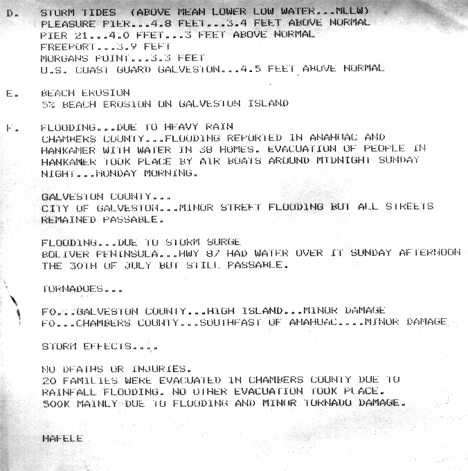
Die Sturmflut verursachte geringe Überschwemmungen an der Küste, insbesondere war davon Galveston Island betroffen.[5] Dean brachte überwiegend leichte Niederschläge nach Texas, obwohl in manchen Gebieten mehr als 200 mm Niederschlag verzeichnet wurden; den höchsten Niederschlagswert meldete Monroe City mit 426 mm.[6] Die Niederschläge verursachten lokal leichte bis mäßige Schäden, und wegen Überflutungen mussten im Chambers County 20 Familien ihre Häuser verlassen.[4] Im südöstlichen Texas wurden 38 Häuser überflutet.[5] Im Zusammenhang mit dem Sturm wurden zwei Tornados beobachtet, die keine wesentlichen Schäden verursachten.[7] In Oklahoma sorgte heftiger Regen dafür, dass mehr als 40 Häuser unter Wasser standen, und 24 Fahrzeuge blieben im Hochwasser stecken. Mindestens drei Fernstraßen wurden überflutet, einige Nebenstraßen blieben mehrere Tage unpassierbar.[8] Außerhalb von Oklahoma und Texas sorgten die Reste des Sturms für Regenfälle in zehn weiteren Bundesstaaten, ohne dass mehr als nur geringe Schäden auftraten.[6] Die gemeldeten Vermögensschäden beliefen sich auf etwa 889 US-Dollar.[7] Eine Person wurde durch Auswirkungen des Sturms getötet.[8]
Hurrikan Erin
| Kategorie-2-Hurrikan | |||
|---|---|---|---|
| |||
| Dauer | 31. Juli – 6. August | ||
| Intensität | 85 kn (155 km/h) (1-minütig), 973 hPa | ||

Am 22. Juli verließ eine tropische Welle die Westküste Afrikas und zog langsam zu den Kleinen Antillen, wo das System begann sich zu intensivieren. Am 31. Juli verstärkte es sich in den Tropischen Sturm Erin, als es sich westlich der Turks- und Caicosinseln befand. Trotz zunehmender Windscherung verstärkte sich der Sturm noch am selben Tag zu einem Hurrikan, als er sich Richtung Nordwesten bewegte. Am nächsten Tag erlebte Erin eine weitere Intensivierung und ging mit Windgeschwindigkeiten von 140 km/h in Vero Beach, Indian River County in Florida an Land. Der Sturm schwächte sich über Land rasch zu einem tropischen Sturm ab, bevor er in den warmen Golf von Mexiko zog und sich erneut in einen Hurrikan verstärkte. Am 3. August hatte sich Erin soweit verstärkt, um als ein Hurrikan der Kategorie zwei mit Windgeschwindigkeiten von 155 km/h klassifiziert zu werden. Mit dieser Intensität macht der Hurrikan seinen zweiten Landgang über Pensacola Beach und schwächt sich danach rasch ab. In den nächsten Tagen zieht Erin über den Süden der Vereinigten Staaten bis in den Mittleren Westen, bis sie am 6. August mit einem frontalen System über West Virginia zusammengeführt wird.[9]
Erin war der erste Hurrikan seit Hurrikan Andrew, der einen Landgang über den Vereinigten Staaten machte. In Jamaika lösten Erins äußere Regenbänder heftige Regenfälle aus, sodass dort ein Flugzeug abstürzte. Fünf Menschen starben dabei. Zwei weitere Todesfälle ereigneten sich, als zwei Menschen von einem Blitz getroffen wurden. Obwohl auf den Bahamas starke Winde und heftige Regenfälle erwartet wurden, blieben die Schäden dort in Verbindung mit Erin meist nur gering. An der Küste Floridas ertranken neun Menschen, drei davon durch den Untergang eines Kreuzfahrtschiffes. Über Land sorgten starke Winde von Erin für Schäden an mindestens 2000 Häusern, die meisten davon in Florida Panhandle. Darüber hinaus sorgte der Sturm für einen Stromausfall, von dem eine Million Menschen betroffen waren. Mehrere Tornados sorgten für einige Schäden. In Alabama wurden ebenfalls mehr als 100 Häuser beschädigt. Zwischen 50 und 75 Prozent der Ernte in Baldwin County war verloren. Ähnliche Schäden traten auch in Mississippi auf, wenn auch nur geringe. Einige Gebiete waren vom Starkregen, den Erin auslöste, betroffen. Insgesamt werden 13 Todesfälle und ein Schaden von 700 Millionen Dollar gemeldet.
Tropisches Tiefdruckgebiet Sechs
| Tropisches Tiefdruckgebiet | |||
|---|---|---|---|
| |||
| Dauer | 5. August – 7. August | ||
| Intensität | 30 kn (55 km/h) (1-minütig), 1002 hPa | ||
Der südliche Teil der tropischen Welle, aus der sich Erin bildete, zog Ende Juli weiter in die Karibik. Am 4. August lag das System in der Bucht von Campeche und entwickelte sich bis zum nächsten Tag in das tropische Tiefdruckgebiet Sechs. Das Tiefdruckgebiet bewegte sich am selben Tag allmählich auf Mexiko zu und intensivierte sich weiter. Laut Satellitenbildern blieb die Intensität aber knapp unter der eines tropischen Sturms. Später am 6. August ging das Tiefdruckgebiet in Veracruz an Land und löste sich am nächsten Tag auf.[10]
Hurrikan Felix
| Kategorie-4-Hurrikan | |||
|---|---|---|---|
| |||
| Dauer | 8. August – 22. August | ||
| Intensität | 120 kn (220 km/h) (1-minütig), 929 hPa | ||
Tropischer Sturm Gabrielle
| Tropischer Sturm | |||
|---|---|---|---|
| |||
| Dauer | 9. August – 12. August | ||
| Intensität | 60 kn (110 km/h) (1-minütig), 988 hPa | ||
.JPG)
Hurrikan Humberto
| Kategorie-2-Hurrikan | |||
|---|---|---|---|
| |||
| Dauer | 22. August – 1. September | ||
| Intensität | 95 kn (175 km/h) (1-minütig), 968 hPa | ||
.gif)
Hurrikan Iris
| Kategorie-2-Hurrikan | |||
|---|---|---|---|
| |||
| Dauer | 22. August – 4. September | ||
| Intensität | 95 kn (175 km/h) (1-minütig), 965 hPa | ||
Tropischer Sturm Jerry
| Tropischer Sturm | |||
|---|---|---|---|
| |||
| Dauer | 23. August – 28. August | ||
| Intensität | 35 kn (65 km/h) (1-minütig), 1002 hPa | ||
Tropischer Sturm Karen
| Tropischer Sturm | |||
|---|---|---|---|
| |||
| Dauer | 26. August – 3. September | ||
| Intensität | 45 kn (85 km/h) (1-minütig), 1000 hPa | ||
Hurrikan Luis
| Kategorie-4-Hurrikan | |||
|---|---|---|---|
| |||
| Dauer | 27. August – 11. September | ||
| Intensität | 120 kn (220 km/h) (1-minütig), 935 hPa | ||
Tropisches Tiefdruckgebiet Vierzehn
| Tropisches Tiefdruckgebiet | |||
|---|---|---|---|
| |||
| Dauer | 9. September – 13. September | ||
| Intensität | 30 kn (55 km/h) (1-minütig), 1008 hPa | ||
Hurrikan Marilyn
| Kategorie-3-Hurrikan | |||
|---|---|---|---|
| |||
| Dauer | 12. September – 22. September | ||
| Intensität | 100 kn (185 km/h) (1-minütig), 949 hPa | ||
Hurrikan Noel
| Kategorie-1-Hurrikan | |||
|---|---|---|---|
| |||
| Dauer | 26. September – 7. Oktober | ||
| Intensität | 65 kn (120 km/h) (1-minütig), 987 hPa | ||
Hurrikan Opal
| Kategorie-4-Hurrikan | |||
|---|---|---|---|
| |||
| Dauer | 27. September – 5. Oktober | ||
| Intensität | 130 kn (240 km/h) (1-minütig), 916 hPa | ||
Tropischer Sturm Pablo
| Tropischer Sturm | |||
|---|---|---|---|
| |||
| Dauer | 4. Oktober – 8. Oktober | ||
| Intensität | 50 kn (95 km/h) (1-minütig), 994 hPa | ||
.gif)
Hurrikan Roxanne
| Kategorie-3-Hurrikan | |||
|---|---|---|---|
| |||
| Dauer | 7. Oktober – 21. Oktober | ||
| Intensität | 100 kn (185 km/h) (1-minütig), 956 hPa | ||
Tropischer Sturm Sebastien
| Tropischer Sturm | |||
|---|---|---|---|
| |||
| Dauer | 20. Oktober – 25. Oktober | ||
| Intensität | 55 kn (100 km/h) (1-minütig), 1001 hPa | ||
.JPG)
Hurrikan Tanya
| Kategorie-1-Hurrikan | |||
|---|---|---|---|
| |||
| Dauer | 27. Oktober – 1. November | ||
| Intensität | 75 kn (140 km/h) (1-minütig), 972 hPa | ||
Saisonübersicht
1492–1600 | 1601–1700 | 1701–1799 | 1800er | 1810er | 1820er | 1830er | 1840er | 1850er | 1860er | 1870er | 1880–1884 | 1885 | 1886 | 1887 | 1888 | 1889 | 1890 | 1891 | 1892 | 1893 | 1894 | 1895 | 1896 | 1897 | 1898 | 1899 | 1915 | 1916 | 1917 | 1918 | 1919 | 1928 | 1929 | 1930 | 1931 | 1932 | 1933 | 1934 | 1935 | 1936 | 1937 | 1938 | 1939 | 1940 | 1941 | 1942 | 1943 | 1944 | 1945 | 1946 | 1947 | 1948 | 1949 | 1950 | 1951 | 1952 | 1953 | 1954 | 1955 | 1956 | 1957 | 1958 | 1959 | 1960 | 1961 | 1969 | 1970 | 1971 | 1972 | 1973 | 1974 | 1975 | 1976 | 1977 | 1978 | 1979 | 1980 | 1981 | 1982 | 1983 | 1984 | 1985 | 1986 | 1987 | 1988 | 1989 | 1990 | 1991 | 1992 | 1993 | 1994 | 1995 | 1996 | 1997 | 1998 | 1999 | 2000 | 2001 | 2002 | 2003 | 2004 | 2005 | 2006 | 2007 | 2008 | 2009 | 2010 | 2011 | 2012 | 2013 | 2014 | 2015 | 2016 | 2017 | 2018 | 2019 | 2020 | 2021 | 2022 | 2023 | 2024
Weblinks
Einzelnachweise
- ↑ Richard Pasch: Hurricane Allison Preliminary Report. National Hurricane Center, 29. Januar 1996, abgerufen am 7. Oktober 2010 (englisch).
- ↑ Max Mayfield: Tropical Storm Barry Preliminary Report. National Hurricane Center, 19. November 1995, abgerufen am 7. Oktober 2010 (englisch).
- ↑ Miles Lawrence: Tropical Storm Chantal Preliminary Report. National Hurricane Center, 17. November 1995, abgerufen am 7. Oktober 2010 (englisch).
- ↑ a b Lixion Avila: Tropical Storm Dean Preliminary Report. National Hurricane Center, 14. November 1995, abgerufen am 31. Oktober 2014 (englisch).
- ↑ a b NWS Houston/Galveston: Summary of Tropical Storm Dean. (GIF) National Oceanic and Atmospheric Administration, 1995, abgerufen am 31. Oktober 2014 (englisch).
- ↑ a b David M. Roth: Tropical Storm Dean – July 28-August 4, 1995. Hydrometeorological Prediction Center, 18. Januar 2007, abgerufen am 31. Oktober 2014 (englisch).
- ↑ a b Gene Hafele: Final Storm Report…Tropical Storm Dean. (GIF) National Oceanic and Atmospheric Administration, 4. August 1995, abgerufen am 31. Oktober 2014 (englisch).
- ↑ a b August 1995 Storm Data. In: National Weather Service. National Oceanic and Atmospheric Administration, August 1995, archiviert vom am 8. Oktober 2006; abgerufen am 29. November 2008 (englisch).
- ↑ Edward Rappaport: Hurricane Erin Preliminary Report. National Hurricane Center, 26. November 1995, abgerufen am 9. Oktober 2012 (englisch).
- ↑ Richard Pasch: Tropical Depression Six Preliminary Report. National Hurricane Center, 10. Januar 1996, abgerufen am 9. Oktober 2012 (englisch).
Auf dieser Seite verwendete Medien

Track map of Hurricane Tanya of the 1995 Atlantic hurricane season. The points show the location of the storm at 6-hour intervals. The colour represents the storm's maximum sustained wind speeds as classified in the (see below), and the shape of the data points represent the nature of the storm, according to the legend below.
Storm type

Track map of Tropical Storm Sebastien of the 1995 Atlantic hurricane season. The points show the location of the storm at 6-hour intervals. The colour represents the storm's maximum sustained wind speeds as classified in the (see below), and the shape of the data points represent the nature of the storm, according to the legend below.
Storm type

Track map of Tropical Storm Barry of the 1995 Atlantic hurricane season. The points show the location of the storm at 6-hour intervals. The colour represents the storm's maximum sustained wind speeds as classified in the (see below), and the shape of the data points represent the nature of the storm, according to the legend below.
Storm type

Track map of Hurricane Roxanne of the 1995 Atlantic hurricane season. The points show the location of the storm at 6-hour intervals. The colour represents the storm's maximum sustained wind speeds as classified in the (see below), and the shape of the data points represent the nature of the storm, according to the legend below.
Storm type

Hurricane Wilma was a powerful Category 5 storm when the Moderate Resolution Imaging Spectroradiometer (MODIS) on NASA’s Terra satellite took this image at 12:40 p.m. Eastern Daylight Time, on October 19, 2005. Less than 24 hours before this image was taken, Wilma had rapidly grown into a record-breaking, powerful storm. Winds around the eyewall of the storm were raging at 280 kilometers per hour (175 miles per hour). Just hours before, National Oceanographic and Atmospheric Administration (NOAA) aircraft measured a record-low air pressure of 882 millibars in the center of Hurricane Wilma, making it the most intense hurricane ever observed in the Atlantic basin. Wilma also broke records for the fastest development of a storm, going from tropical storm status to Category 5 hurricane in less than 24 hours.
The high-resolution image provided above has a spatial resolution of 250 meters per pixel. The MODIS Rapid Response Team provides this image at additional resolutions.
Hurricane Iris at peak strength on September 3, 1995.

Track map of Tropical Storm Chantal of the 1995 Atlantic hurricane season. The points show the location of the storm at 6-hour intervals. The colour represents the storm's maximum sustained wind speeds as classified in the (see below), and the shape of the data points represent the nature of the storm, according to the legend below.
Storm type

Track map of Tropical Depression Fourteen of the 1995 Atlantic hurricane season. The points show the location of the storm at 6-hour intervals. The colour represents the storm's maximum sustained wind speeds as classified in the (see below), and the shape of the data points represent the nature of the storm, according to the legend below.
Storm type

Picture of TD14 of the 1995 season.Produced by the NHC.

Track map of Tropical Storm Karen of the 1995 Atlantic hurricane season. The points show the location of the storm at 6-hour intervals. The colour represents the storm's maximum sustained wind speeds as classified in the (see below), and the shape of the data points represent the nature of the storm, according to the legend below.
Storm type

Track map of Hurricane Allison of the 1995 Atlantic hurricane season. The points show the location of the storm at 6-hour intervals. The colour represents the storm's maximum sustained wind speeds as classified in the (see below), and the shape of the data points represent the nature of the storm, according to the legend below.
Storm type

Hurricane Luis at peak intensity on September 3 at 1705 UTC. This image was produced from data from NOAA-14, provided by NOAA. Maximum sustained winds were 140 mph at the time this image was captured.

Track map of Hurricane Noel of the 1995 Atlantic hurricane season. The points show the location of the storm at 6-hour intervals. The colour represents the storm's maximum sustained wind speeds as classified in the (see below), and the shape of the data points represent the nature of the storm, according to the legend below.
Storm type

Hurricane Allison at peak intensity on June 4 at 1313 UTC. This image was produced from data from NOAA-12, provided by NOAA. Maximum sustained winds were about 75 mph at this time.

Track map of Tropical Storm Gabrielle of the 1995 Atlantic hurricane season. The points show the location of the storm at 6-hour intervals. The colour represents the storm's maximum sustained wind speeds as classified in the (see below), and the shape of the data points represent the nature of the storm, according to the legend below.
Storm type

Track map of Hurricane Luis of the 1995 Atlantic hurricane season. The points show the location of the storm at 6-hour intervals. The colour represents the storm's maximum sustained wind speeds as classified in the (see below), and the shape of the data points represent the nature of the storm, according to the legend below.
Storm type

Hurricane Marilyn at peak intensity on September 16 at 1811 UTC.
- Maximum sustained winds were 115 mph at the time.
- This image was produced from data from NOAA-14, provided by NOAA.

Image of Tropical Storm Barry of the 1995 Atlantic hurricane season on 7. Juli 1995

Track map of Hurricane Iris of the 1995 Atlantic hurricane season. The points show the location of the storm at 6-hour intervals. The colour represents the storm's maximum sustained wind speeds as classified in the (see below), and the shape of the data points represent the nature of the storm, according to the legend below.
Storm type

Image of Tropical Storm Karen of the 1995 Atlantic hurricane season on 28. August 1995

Image of Tropical Storm Chantal of the 1995 Atlantic hurricane season on 1995

Track map of Tropical Storm Dean of the 1995 Atlantic hurricane season. The points show the location of the storm at 6-hour intervals. The colour represents the storm's maximum sustained wind speeds as classified in the (see below), and the shape of the data points represent the nature of the storm, according to the legend below.
Storm type
This map shows the tracks of all tropical cyclones in the 1995 Atlantic hurricane season. The points show the location of each storm at 6-hour intervals. The colour represents the storm's maximum sustained wind speeds as classified in the Saffir-Simpson Hurricane Scale (see below), and the shape of the data points represent the type of the storm.

Hurricane Felix near peak intensity on August 12 at 1747 UTC. This image was produced from data from NOAA-14, provided by NOAA. Maximum sustained winds were about 140 mph at this time.

Track map of Hurricane Opal of the 1995 Atlantic hurricane season. The points show the location of the storm at 6-hour intervals. The colour represents the storm's maximum sustained wind speeds as classified in the (see below), and the shape of the data points represent the nature of the storm, according to the legend below.
Storm type

Track map of Tropical Storm Jerry of the 1995 Atlantic hurricane season. The points show the location of the storm at 6-hour intervals. The colour represents the storm's maximum sustained wind speeds as classified in the (see below), and the shape of the data points represent the nature of the storm, according to the legend below.
Storm type

Track map of Hurricane Felix of the 1995 Atlantic hurricane season. The points show the location of the storm at 6-hour intervals. The colour represents the storm's maximum sustained wind speeds as classified in the (see below), and the shape of the data points represent the nature of the storm, according to the legend below.
Storm type

Image of Tropical Storm Jerry of the 1995 Atlantic hurricane season on 23. August 1995

Track map of Tropical Depression Six of the 1995 Atlantic hurricane season. The points show the location of the storm at 6-hour intervals. The colour represents the storm's maximum sustained wind speeds as classified in the (see below), and the shape of the data points represent the nature of the storm, according to the legend below.
Storm type

Track map of Hurricane Humberto of the 1995 Atlantic hurricane season. The points show the location of the storm at 6-hour intervals. The colour represents the storm's maximum sustained wind speeds as classified in the (see below), and the shape of the data points represent the nature of the storm, according to the legend below.
Storm type

Hurricane Tanya at peak strength on October 31, 1995.

Hurricane Opal in the Gulf of Mexico on October 3 at 2012 UTC. This image was produced from data from NOAA-14, provided by NOAA.
_color.jpg)
This image shows Hurricane Noel as a minimal hurricane in late September of 1995 in the open tropical Atlantic Ocean.

Picture of TD6 of the 1995 season.Produced by the NHC.

Track map of Tropical Storm Pablo of the 1995 Atlantic hurricane season. The points show the location of the storm at 6-hour intervals. The colour represents the storm's maximum sustained wind speeds as classified in the (see below), and the shape of the data points represent the nature of the storm, according to the legend below.
Storm type

Track map of Hurricane Erin of the 1995 Atlantic hurricane season. The points show the location of the storm at 6-hour intervals. The colour represents the storm's maximum sustained wind speeds as classified in the (see below), and the shape of the data points represent the nature of the storm, according to the legend below.
Storm type

This thermal infrared image of Hurricane Roxanne was taken on October 11 at 0315 UTC.

Track map of Hurricane Marilyn of the 1995 Atlantic hurricane season. The points show the location of the storm at 6-hour intervals. The colour represents the storm's maximum sustained wind speeds as classified in the (see below), and the shape of the data points represent the nature of the storm, according to the legend below.
Storm type