Assateague Island
| Assateague Island | ||
|---|---|---|
 | ||
| Gewässer | Atlantischer Ozean | |
| Geographische Lage | 38° 5′ N, 75° 13′ W | |
| Länge | 60 km | |
| Einwohner | unbewohnt | |

Assateague Island ist eine unbewohnte amerikanische Insel in Maryland und Virginia.[1] Die längliche Düneninsel an der Ostküste der Vereinigten Staaten von Amerika ist in Nord-Süd-Richtung 60 km lang. Die Vereinten Nationen haben Assateague Island zum Biosphärenreservat erklärt. Das Innenministerium der Vereinigten Staaten hat die gesamte Insel zum National Natural Landmark erklärt.
Auf der Insel finden sich Marschland, Buchten, Sandstrände und Sandbuchten.[2]
Es gibt drei Naturschutzbehörden auf der Insel, die zuständig sind:
- Maryland (beide IUCN-Kategorie V)
- Assateague Island National Seashore
- Assateague State Park (3,2 km²)
- Virginia
- Chincoteague National Wildlife Refuge, 57 km² (IUCN-Kategorie IV).
Auf der Insel existieren wildlebende Assateague-Ponys (Chincoteague).[3]
Die Grenze zwischen den Bundesstaaten auf der Insel ist durch einen hohen Zaun markiert. Die Freiwillige Feuerwehr Chincoteague Volunteer Fire Department in Chincoteague (Virginia) besitzt die größte Herde der Chincoteague-Ponys auf dem Eiland.

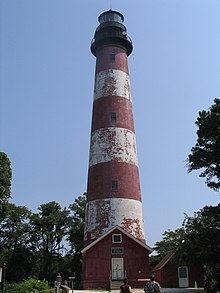
An der Virginia Eastern Shore befindet sich der Leuchtturm Assateague Lighthouse aus den 1830er Jahren mit einer Höhe von 43 m am Südende von Assateague Island. Es ist im National Register of Historic Places eingetragen.
Siehe auch
- National Seashore
Literatur
- John Amrhein jr.: The Hidden Galleon: The True Story of a Lost Spanish Ship and the Legendary Wild Horses of Assateague Island New Maritima Pr 2007
Weblinks
Einzelnachweise
- ↑ Kenney, Nathaniel T., „Watermen's Island Home“, National Geographic Magazine, Index (January–June 1980), vol. 157 (June 1980): 812.
- ↑ GMCO Maps & Charts. GMCO's Fishing & Recreation Map of Chincoteague-Assateague, Virginia, 2003.
- ↑ Assateague Island National Seashore page on wild horses National Park Service.
Auf dieser Seite verwendete Medien
Aerial view of Assateague Island on the Atlantic Ocean in Maryland, USA.
- The photograph shows the erosion to the beaches due to Atlantic storms.
- In the far distance at the top right is Ocean City, Maryland.
Assateague Lighthouse, Aug 2007
Autor/Urheber: SANtosito, Lizenz: CC BY-SA 4.0
Relief location map of Maryland, USA
Geographic limits of the map:
- N: 40.0° N
- S: 37.6° N
- W: 79.7° W
- E: 74.8° W


