Asian Highway 1
| Asian Highway 1 | |||||||||||||||||||||||||||||||||||||||||||||||||||||||||||||||||||||||||||||||||||||||||||||||||||||||||||||||||||||||||||||||||||||||||||||||||||||||||||||||||||||||||||||||||||||||||||||||||||||||||||||||||||||||||||||||||||||||||||||||||||||||||||||||||||||||||||||||||||||||||||||||||||||||||||||||||||||||||||||||||||||||||||||||||||||||||||||||||||||||||||||||||||||||||||||||||||||||||||||||||||||||||||||||
 | |||||||||||||||||||||||||||||||||||||||||||||||||||||||||||||||||||||||||||||||||||||||||||||||||||||||||||||||||||||||||||||||||||||||||||||||||||||||||||||||||||||||||||||||||||||||||||||||||||||||||||||||||||||||||||||||||||||||||||||||||||||||||||||||||||||||||||||||||||||||||||||||||||||||||||||||||||||||||||||||||||||||||||||||||||||||||||||||||||||||||||||||||||||||||||||||||||||||||||||||||||||||||||||||
| Karte | |||||||||||||||||||||||||||||||||||||||||||||||||||||||||||||||||||||||||||||||||||||||||||||||||||||||||||||||||||||||||||||||||||||||||||||||||||||||||||||||||||||||||||||||||||||||||||||||||||||||||||||||||||||||||||||||||||||||||||||||||||||||||||||||||||||||||||||||||||||||||||||||||||||||||||||||||||||||||||||||||||||||||||||||||||||||||||||||||||||||||||||||||||||||||||||||||||||||||||||||||||||||||||||||
 | |||||||||||||||||||||||||||||||||||||||||||||||||||||||||||||||||||||||||||||||||||||||||||||||||||||||||||||||||||||||||||||||||||||||||||||||||||||||||||||||||||||||||||||||||||||||||||||||||||||||||||||||||||||||||||||||||||||||||||||||||||||||||||||||||||||||||||||||||||||||||||||||||||||||||||||||||||||||||||||||||||||||||||||||||||||||||||||||||||||||||||||||||||||||||||||||||||||||||||||||||||||||||||||||
| Basisdaten | |||||||||||||||||||||||||||||||||||||||||||||||||||||||||||||||||||||||||||||||||||||||||||||||||||||||||||||||||||||||||||||||||||||||||||||||||||||||||||||||||||||||||||||||||||||||||||||||||||||||||||||||||||||||||||||||||||||||||||||||||||||||||||||||||||||||||||||||||||||||||||||||||||||||||||||||||||||||||||||||||||||||||||||||||||||||||||||||||||||||||||||||||||||||||||||||||||||||||||||||||||||||||||||||
| Betreiber: | |||||||||||||||||||||||||||||||||||||||||||||||||||||||||||||||||||||||||||||||||||||||||||||||||||||||||||||||||||||||||||||||||||||||||||||||||||||||||||||||||||||||||||||||||||||||||||||||||||||||||||||||||||||||||||||||||||||||||||||||||||||||||||||||||||||||||||||||||||||||||||||||||||||||||||||||||||||||||||||||||||||||||||||||||||||||||||||||||||||||||||||||||||||||||||||||||||||||||||||||||||||||||||||||
| Straßenbeginn: | Tokio (35° 39′ 59″ N, 139° 44′ 19″ O) | ||||||||||||||||||||||||||||||||||||||||||||||||||||||||||||||||||||||||||||||||||||||||||||||||||||||||||||||||||||||||||||||||||||||||||||||||||||||||||||||||||||||||||||||||||||||||||||||||||||||||||||||||||||||||||||||||||||||||||||||||||||||||||||||||||||||||||||||||||||||||||||||||||||||||||||||||||||||||||||||||||||||||||||||||||||||||||||||||||||||||||||||||||||||||||||||||||||||||||||||||||||||||||||||
| Straßenende: | Edirne (41° 43′ 3″ N, 26° 21′ 11″ O) | ||||||||||||||||||||||||||||||||||||||||||||||||||||||||||||||||||||||||||||||||||||||||||||||||||||||||||||||||||||||||||||||||||||||||||||||||||||||||||||||||||||||||||||||||||||||||||||||||||||||||||||||||||||||||||||||||||||||||||||||||||||||||||||||||||||||||||||||||||||||||||||||||||||||||||||||||||||||||||||||||||||||||||||||||||||||||||||||||||||||||||||||||||||||||||||||||||||||||||||||||||||||||||||||
| Gesamtlänge: | 20.557 km | ||||||||||||||||||||||||||||||||||||||||||||||||||||||||||||||||||||||||||||||||||||||||||||||||||||||||||||||||||||||||||||||||||||||||||||||||||||||||||||||||||||||||||||||||||||||||||||||||||||||||||||||||||||||||||||||||||||||||||||||||||||||||||||||||||||||||||||||||||||||||||||||||||||||||||||||||||||||||||||||||||||||||||||||||||||||||||||||||||||||||||||||||||||||||||||||||||||||||||||||||||||||||||||||
Straßenverlauf
| |||||||||||||||||||||||||||||||||||||||||||||||||||||||||||||||||||||||||||||||||||||||||||||||||||||||||||||||||||||||||||||||||||||||||||||||||||||||||||||||||||||||||||||||||||||||||||||||||||||||||||||||||||||||||||||||||||||||||||||||||||||||||||||||||||||||||||||||||||||||||||||||||||||||||||||||||||||||||||||||||||||||||||||||||||||||||||||||||||||||||||||||||||||||||||||||||||||||||||||||||||||||||||||||
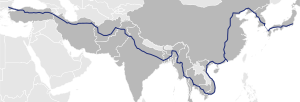
Der Asian Highway 1 (AH1) (englisch für „Asiatische Fernstraße 1“) ist die längste Verbindung im Asiatischen Fernstraßen-Projekt. Mit einer projektierten Länge von 20.557 km führt die Straße von Tokio (Japan) über Korea, die Volksrepublik China, Südostasien, Indien, Iran bis über den Bosporus (Türkei).
Ähnlich den Europastraßen werden existierende Strecken zusätzlich mit der Bezeichnung „AH1“ ausgestattet. Die teilnehmenden Staaten haben sich verpflichtet, den Ausbaustandard der transnationalen Straßen zu erhöhen und für eine Verbindung wie den AH1 zu autobahnähnlichen Fernstraßen fortzuentwickeln.
Japan


Mit der Ausweisung als AH1 seit November 2003[1] verläuft die Fernstraße in Japan über 1200 Kilometer[2] entlang der folgenden (mautpflichtigen) Autobahnen:[3]

 Stadtautobahn Tokio C1 (Innerer Ring) und 3 (Shibuya-Linie)
 Tōmei-Autobahn[4], von Tokyo nach Komaki
 Meishin-Autobahn, von Komaki über Kyōto nach Suita
 Chūgoku-Autobahn, von Suita nach Kōbe
 San’yō-Autobahn, von Kōbe über Hiroshima nach Yamaguchi
 Chūgoku-Autobahn, von Yamaguchi nach Shimonoseki
 Kammon-Autobahn (Kammon-Brücke), von Shimonoseki nach Kitakyūshū
 Kyūshū-Autobahn, von Kitakyūshū nach Fukuoka
 Fukuoka-Autobahn 4 und 1 in Fukuoka
Von Fukuoka führt die AH1 als Fährverbindung nach Busan in Südkorea – der vorgeschlagene Japan-Korea-Tunnel könnte eine Verbindung mit fester Fahrbahn ermöglichen.
Südkorea

Die AH1 folgte weitgehend der Gyeongbu-Autobahn:
 Fernstraße 1 der Gyeongbu-Autobahn von Busan zur Hannam-Brücke in Seoul
- Fernstraße 1 der Einheitsstraße von der Seongsan-Brücke in Seoul nach Panmunjeom in Paju, Gyeonggi-do.
- Grenze
 Nordkorea
Nordkorea

- Grenze
 Südkorea
P'anmunjǒm über Gaeseong und P'yǒngyang (Pjöngjang-Kaesŏng-Schnellstraße) nach Sinǔiju über die Pjöngjang-Sinŭiju-Schnellstraße
- Grenze
 Volksrepublik China
China
- Grenze
 Nordkorea
  G304: Dandong – Shenyang
 G102: Shenyang – Peking
 S382: Peking – Shijiazhuang
 G107: Shijiazhuang – Zhengzhou
 G310: Zhengzhou – Xinyang – Wuhan
 G107: Wuhan – Changsha
 G322: Nanning – Youyiguan – Guangzhou – Xiangtan
- Grenze
 Vietnam
Vietnam
- Grenze
 Volksrepublik China
  Nationalstraße 1: Ho-Chi-Minh-Stadt – Biên Hòa – Nha Trang – Hội An – Đà Nẵng – Huế – Đông Hà – Dong Hoi – Vinh – Hanoi
- Fernstraße 22: Moc Bai – Ho Chi Minh City
- Fernstraße 279: Dong Dang – Huu Nghi
- Fernstraße 51: Abzweig von Bien Hoa nach Vung Tau
- Grenze
 Kambodscha
Kambodscha
- Grenze
 Vietnam
  Nationalstraße 1: Bavet – Phnom Penh
 Nationalstraße 5: Phnom Penh – Poipet
- Grenze
 Thailand
Thailand
- Grenze
 Kambodscha
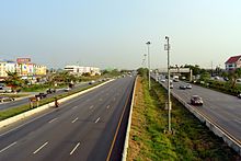
  Thai Highway 33: Aranyaprathet (Provinz Sa Kaeo) – Nakhon Nayok – Hin Kong (Landkreis Nong Khae, Provinz Saraburi)
 Thanon Phahonyothin: Hin Kong (Landkreis Nong Khae, Provinz Saraburi) – Bang Pa In
 Thanon Phahonyothin: Abzweig von Bang Pa In nach Bangkok
 Thai Highway 32: Bang Pa In – Chai Nat
 Thanon Phahonyothin: Chai Nat – Nakhon Sawan – Tak
 Thai Highway 105 Tak – Mae Sot
- Grenze
 Myanmar
Myanmar
- Grenze
 Thailand
 - Fernstraße 85 Myawaddy – Thaton
- Fernstraße 8 Thaton – Bago
- Fernstraße 1 Bago – Naypyidaw
- Yangon-Mandalay Expressway Naypyidaw – Mandalay
- Fernstraße 7 Mandalay – Tamu
- Grenze
 Indien
Indien
- Grenze
 Myanmar
  Moreh – Imphal – Kohima – Dimapur
 Dimapur – Nagaon
 Nagaon – Numaligarh – Jorabat
 Abzweig von Jorabat nach Guwahati
 Jorabat – Shillong – Dawki
- Grenze
 Bangladesch
Bangladesch
- Grenze
 Indien
 - N2 Tamabil – Sylhet – Katchpur – Dhaka
- N4 Dhaka – Tangail
- N405 Tangail – Kamarkhanda
- N704 Kamarkhanda – Jessore
- N706 Jessore – Benapole[5]
- Grenze
 Indien
Indien
- Grenze
 Bangladesch
  Petrapole – Barasat
 Barasat – Kolkata
 Kolkata – Barhi – Kanpur – Agra – New Delhi
 New Delhi – Attari
- Grenze
 Pakistan
Pakistan
- Grenze
 Indien
 - Wagah – Lahore
 M-2: Lahore – Islamabad
 M-1: Islamabad – Peschawar
 N-5: Peschawar – Torcham
- Khyber Pass
- Grenze
 Afghanistan
Afghanistan
- Grenze
 Pakistan
 - Khyber Pass
- A01 Torkham – Dschalalabad – Kabul – Kandahar – Dilaram – Herat – Islam Qala
- Grenze
 Iran
Iran
Iran
- Grenze
 Afghanistan
 - A101 A78-2- 13: Road 22: Dogharun – Sang Bast – Maschhad
- A78- 2 Road 44: Maschhad – Eman Taqi
- A83- 6: Eman Taqi – Sabzevar – Damghan – Semnan – Teheran
- A01- 4-Freeway 2: Teheran
- A01- 4-5: Qazvin
- A01- 4: Täbris – Eyvoghli – Bazargan
- Grenze
 Türkei
Türkei und Verbindung zur Europastraße 80


- Grenze
 Iran
Iran  Europastraße 80 / Fernstraße 100 Gürbulak – Doğubeyazıt – Aşkale – Refahiye – Sivas
 Europastraße 88 / Fernstraße 100 Sivas – Ankara
 Europastraße 89 /
  Autobahn O-4 Ankara – Gerede – İstanbul
 Europastraße 80 /
  Autobahn O-2 Istanbul – Fatih-Sultan-Mehmet-Brücke
 Europastraße 80 /
  Autobahn O-3 Istanbul – Edirne
 Europastraße 80 / Fernstraße 100 Edirne – Kapıkule
- Grenze
 Bulgarien
Die Strecke der AH1 ist in der Türkei zusätzlich als Europastraße 80 ausgezeichnet – diese Verbindung führt ab der Grenze mit Bulgarien bei Kapitan Andreevo/Kapıkule nach Sofia, von dort weiter nach Priština, Dubrovnik, Pescara, Rom, Genua, Nizza, Toulouse, Burgos, Salamanca bis nach Lissabon.
Medien
- fernOst – Von Berlin nach Tokio – Roadtrip entlang des Asian Highway 1, eine Arte/RBB Koproduktion.
Einzelnachweise
- ↑ Economic and Social Commission for Asia and the Pacific, 2003 Asian Highway Handbook (Memento vom 14. April 2012 im Internet Archive) (PDF; 2,3 MB), 2003, page 3
- ↑ Economic and Social Commission for Asia and the Pacific, 2003 Asian Highway Handbook (Memento vom 14. April 2012 im Internet Archive) (PDF; 2,3 MB), 2003, page 54
- ↑ アジアハイウェイ標識の設置場所. MLIT, abgerufen am 5. Dezember 2011 (japanisch).
- ↑ Economic and Social Commission for Asia and the Pacific, 2003 Asian Highway Handbook (Memento vom 14. April 2012 im Internet Archive) (PDF; 2,3 MB), 2003, page 54 shows an aerial photo of the Yokohama Aoba Interchange, placing AH1 clearly on the Tomei Expressway rather than the other Tokyo-Nagoya expressway, the Chūō Expressway.
- ↑ rhd.gov.bd (Memento des vom 13. Oktober 2017 im Internet Archive) Info: Der Archivlink wurde automatisch eingesetzt und noch nicht geprüft. Bitte prüfe Original- und Archivlink gemäß Anleitung und entferne dann diesen Hinweis. (PDF; 2,8 MB)
Auf dieser Seite verwendete Medien
(c) OOjs UI Team and other contributors, MIT
An icon from the OOjs UI MediaWiki lib.
Flagge des Irans. Die dreifarbige Flagge wurde 1906 eingeführt, aber nach der Islamischen Revolution von 1979 wurden die Arabische Wörter 'Allahu akbar' ('Gott ist groß'), in der Kufischen Schrift vom Koran geschrieben und 22-mal wiederholt, in den roten und grünen Streifen eingefügt, so daß sie an den zentralen weißen Streifen grenzen.
Pakistan motorway 2 sign
State road number plate
Indian National Highway 36 sign
Plate number of National route in Vietnam
Thailand Highway shield (32)
Schild des Asiatische Fernstraße 1
Autor/Urheber: Dake (Diskussion · Beiträge), Booyabazooka (Diskussion · Beiträge), Roulex 45 (Diskussion · Beiträge), and Doodledoo (Diskussion · Beiträge), Lizenz: CC BY-SA 2.5
Diese W3C-unbestimmte Vektorgrafik wurde mit Inkscape erstellt .
Thailand Highway shield (12)
Schild des Asiatische Fernstraße 2
Autor/Urheber: Adbar, Lizenz: CC BY-SA 3.0
AH1, AH2 and Thailand Route 32 in Ayutthaya
Plate number of National Route 1, Vietnam
This is a diagram of Chūgoku Expwy route sign. This image's glyphs are the outline path from free font that is "GD-HighwayGothicJA(pumpCurry)". If you want to change the glyphs, you MUST check the license of substitute glyphs/fonts.
Straßenschild der Nationalstraße 5 in Kambodscha
Pakistan motorway 1 sign
Indian National Highway 37 sign
State road number plate
Indian National Highway 35 sign
Indian National Highway 19 sign
The Sino-Korean Friendship Bridge across the Yalu (Amnokgang) at Sinuiju and Dandong.
中國107國道標誌
Illustration of route marker
This is a diagram of Kyūshū Expwy route sign. This image's glyphs are the outline path from free font that is "GD-HighwayGothicJA(pumpCurry)". If you want to change the glyphs, you MUST check the license of substitute glyphs/fonts.
中国の国道の標識
Autor/Urheber: 쿠도군 from kowp, Lizenz: CC BY 2.0 kr
Asian Highway No.1 Gyongbu Expressway
Autor/Urheber: Original photographer was User:Shinkansen, Lizenz: CC BY-SA 3.0
Kanmonkyo Bridge. Smaller version of Image:Kanmonkyo-mimosuso.JPG. Cropped, rotated, exposure adjusted, color adjusted, power-line digitally retouched in upper left corner. Original photographer was User:Shinkansen.
Indian National Highway 40 sign
Autor/Urheber: katorisi, Lizenz: CC BY-SA 3.0
The starting point of Asian highway Route 1,Chuo-city,Tokyo,Japan.
Thailand Highway shield (105)
European route number plate
This is a diagram of Meishin Expwy route sign. This image's glyphs are the outline path from free font that is "GD-HighwayGothicJA(pumpCurry)". If you want to change the glyphs, you MUST check the license of substitute glyphs/fonts.
中国の国道の標識
Straßenschild der Nationalstraße 1 in Kambodscha
This is a diagram of Sanyō Expwy route sign. This image's glyphs are the outline path from free font that is "GD-HighwayGothicJA(pumpCurry)". If you want to change the glyphs, you MUST check the license of substitute glyphs/fonts.
This is a diagram of Shuto Urban Expwy
Sign. This image's glyphs are the outline path from free font that is "VL Gothic". If you want to change the glyphs, you MUST check the license of substitute glyphs/fonts.
This is a diagram of Kanmonkyo_Bridge route sign. This image's glyphs are the outline path from free font that is "GD-HighwayGothicJA(pumpCurry)". If you want to change the glyphs, you MUST check the license of substitute glyphs/fonts.
Korea Expressway No.1 Sign.
European route number plate
Plate number of National route in Vietnam
European route number plate
This is a diagram of Tōmei Expwy route sign. This image's glyphs are the outline path from free font that is "GD-HighwayGothicJA(pumpCurry)". If you want to change the glyphs, you MUST check the license of substitute glyphs/fonts.
中国の国道の標識
中国の国道の標識
中国の国道の標識
Autor/Urheber: Lerdsuwa, Lizenz: CC BY-SA 3.0
Thai-Myanmar Friendship Bridge on Asian Highway 1 linking Amphoe Mae Sot, Tak, Thailand with Myawaddy, Karen State, Myanmar. Photo taken on Thai side.
Indian National Highway 34 sign
(c) Foto: Reinhard Kraasch, Lizenz: CC-BY-SA 4.0 DE
Asian Highway 1 / Nationalstraße 1A bei Phú Lộc in Vietnam
This is a diagram of Shuto Urban Expwy
Sign. This image's glyphs are the outline path from free font that is "VL Gothic". If you want to change the glyphs, you MUST check the license of substitute glyphs/fonts.
Sign for Route 10 of Hong Kong
대한민국 도시고속화도로 11호선. 어느 도시나 도시고속화도로에는 이 기호를 사용한다.
Illustration of route marker
Sign of Iran Freeway 2
A depiction of an MUTCD-standard car ferry sign. This would normally be used with directional road signs to indicate that a route leads to af ferry dock.
Indian National Highway 39 sign
Thailand Highway shield (1)
Indian National Highway 1 sign
Illustration of route marker
Pakistan national highway 5 sign
Sinnbild innerorts
Indian National Highway 2 sign
Thailand Highway shield (33)
Autor/Urheber: James Mollison, Lizenz: CC BY-SA 2.5
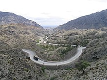
Chaiber-Pass Blick Richtung Pakistan
Korea National Route 1 Sign.


