Arrowsmith-Halbinsel
| Arrowsmith-Halbinsel | |
| Geographische Lage | |
 | |
| Koordinaten | 67° 15′ S, 67° 15′ W |
| Lage | Loubet-Küste, Grahamland, Antarktika |
| Gewässer 1 | Cole Channel und Hanusse-Bucht |
| Gewässer 2 | Lallemand-Fjord und Bigourdan-Fjord |
| Länge | 65 km |
Die Arrowsmith-Halbinsel ist eine rund 65 km lange Halbinsel am Südteil der Loubet-Küste des Grahamlands auf der Antarktischen Halbinsel. Sie liegt westlich des Forel-Gletschers und des Sharp-Gletschers. Die Südküste der Halbinsel bildet die nördliche Begrenzung der Marguerite Bay.
Vermessen wurde das Gebiet zwischen 1955 und 1958 durch den Falkland Islands Dependencies Survey. Benannt ist die Halbinsel nach Edwin Porter Arrowsmith (1909–1992), Gouverneur der Falklandinseln von 1957 bis 1964.
Weblinks
- Arrowsmith Peninsula. In: Geographic Names Information System. United States Geological Survey, United States Department of the Interior, archiviert vom (englisch).
- Arrowsmith Peninsula auf geographic.org (englisch)
Auf dieser Seite verwendete Medien
Autor/Urheber: Vincent van Zeijst, Lizenz: CC BY-SA 3.0
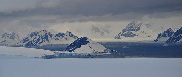
Laubeuf Fjord in the Antarctic Peninsula region, seen from a position high on the Wormald Ice Piedmont on Adelaide Island. Viewing direction is toward the NE. In the centre, behind some of the ice cliffs of the piedmont, is Webb Island. Left of Webb Island and further away is Wyatt Island. All the mountains in the background are on the Arrowsmith Peninsula, which is part of the Loubet Coast of the Antarctic Peninsula. The dark mountains at the right edge are the northernmost peaks of the Haslam Heights. The long front of coastal ice cliffs left of these peaks are the mouths of the Vallot Glacier and Ward Glacier. The large mountain behind this ice front is Pryor Peak; it is more than 1000 m high and is part of the Tyndall Mountains.
Autor/Urheber: Edited by Apcbg, Lizenz: CC BY 3.0
Location of Arrowsmith Peninsula, Antarctica.


