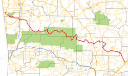
Arkansas State Route 16
 | |
|---|---|
| Karte | |
 | |
| Basisdaten | |
| Gesamtlänge: | 227,3 Meilen / 365,7 Kilometer |
| Anfangspunkt: | |
| Endpunkt: | |
| Wichtige Städte: | Fayetteville Clinton Heber Springs |
Die Arkansas State Route 16 (kurz AR 16) ist eine Ost-West-Richtung verlaufende State Route im US-Bundesstaat Arkansas.
Die State Route beginnt am U.S. Highway 412 in Siloam Springs und endet in Searcy am U.S. Highway 67. Die Straße ist größtenteils eine ländliche zweispurige Straße. Sie trifft bei Fayetteville auf die U.S. Highways 62 und 71.
Siehe auch
Weblinks
Auf dieser Seite verwendete Medien
24 in by 24 in (600 mm by 600 mm) Arkansas State Highway shield. Uses the Roadgeek 2005 fonts. (United States law does not permit the copyrighting of typeface designs, and the fonts are meant to be copies of a U.S. Government-produced work anyway.)
750 mm × 600 mm (30 in × 24 in) U.S. Highway shield, made to the specifications of the 2004 edition of Standard Highway Signs. (Note that there is a missing "J" label on the left side of the diagram.) Uses the Roadgeek 2005 fonts. (United States law does not permit the copyrighting of typeface designs, and the fonts are meant to be copies of a U.S. Government-produced work anyway.)
600 mm × 600 mm (24 in × 24 in) U.S. Highway shield, made to the specifications of the 2004 edition of Standard Highway Signs. (Note that there is a missing "J" label on the left side of the diagram.) Uses the Roadgeek 2005 fonts. (United States law does not permit the copyrighting of typeface designs, and the fonts are meant to be copies of a U.S. Government-produced work anyway.)


