Arizona State Route 98
 | |
|---|---|
| Karte | |
 | |
| Basisdaten | |
| Gesamtlänge: | 67 mi/108 km |
| Anfangspunkt: | |
| Endpunkt: | |
| County: | Coconino County |
| Wichtige Städte: | Page Kaibito Shonto |
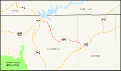
Die Arizona State Route 98 (kurz AZ 98) ist eine State Route im US-Bundesstaat Arizona, die in Ost-West-Richtung verläuft. Die rund 67 Meilen (108 km) lange Straße beginnt am U.S. Highway 89 in Page und endet am U.S. Highway 160 östlich von Cow Springs.
Die State Route führt zum Großteil durch dünnbesiedelte Gebiete sowie durch die Navajo Indian Reservation.


Verlauf
Die Arizona State Route 98 beginnt südlich von Page an der Kreuzung mit dem U.S. Highway 89. Nach wenigen Meilen führt sie an dem kleinen Dorf Lechee vorbei. Weiter östlich passiert die Straße im Norden die Navajo Generating Station und durchschneidet den Antelope Canyon. Bis Kaibito verläuft die Trasse zunächst in südlicher Richtung parallel zu den Gleisen der Black Mesa and Lake Powell Railroad. Dabei wird hauptsächlich trockenes Wüstengebiet durchquert. Im Anschluss schwenkt die Straße in Richtung Südosten und windet sich in vielen Kurven durch eine hügelige Landschaft. Kurz vor der Kreuzung mit dem U.S. Highway 160 passiert die AZ 98 im Norden die Ortschaft Shonto.
Siehe auch
Weblinks
Auf dieser Seite verwendete Medien
Autokreuzung (Icon) in grün.
750 mm × 600 mm (30 in × 24 in) U.S. Highway shield, made to the specifications of the 2004 edition of Standard Highway Signs. (Note that there is a missing "J" label on the left side of the diagram.) Uses the Roadgeek 2005 fonts. (United States law does not permit the copyrighting of typeface designs, and the fonts are meant to be copies of a U.S. Government-produced work anyway.)
Autor/Urheber: Patrick Pelster, Lizenz: CC BY-SA 3.0
Die Arizona State Route 98 wenige Meilen östlich von Page, Arizona.
24 in by 24 in (600 mm by 600 mm) Arizona State Route shield, made to the specifications of the sign detail. Uses the Roadgeek 2005 fonts. (United States law does not permit the copyrighting of typeface designs, and the fonts are meant to be copies of a U.S. Government-produced work anyway.)
Autor/Urheber: Patrick Pelster, Lizenz: CC BY-SA 3.0
Die Arizona State Route 98 östlich von Kaibito, Arizona.
Autor/Urheber: Arkyan, Lizenz: CC BY-SA 3.0
Map of Arizona State Route 98.
600 mm × 600 mm (24 in × 24 in) U.S. Highway shield, made to the specifications of the 2004 edition of Standard Highway Signs. (Note that there is a missing "J" label on the left side of the diagram.) Uses the Roadgeek 2005 fonts. (United States law does not permit the copyrighting of typeface designs, and the fonts are meant to be copies of a U.S. Government-produced work anyway.)
Autor/Urheber: Patrick Pelster, Lizenz: CC BY-SA 3.0
Die Arizona State Route 98 östlich von Kaibito, Arizona.


