Arizona State Route 80
 | |
|---|---|
| Karte | |
 | |
| Basisdaten | |
| Gesamtlänge: | 120 mi/193 km |
| Eröffnung: | 1989 |
| Anfangspunkt: | |
| Endpunkt: | |
| County: | Cochise County |
| Wichtige Städte: | Tombstone Bisbee Douglas |
Die Arizona State Route 80 (kurz AZ 80) ist eine State Route im US-Bundesstaat Arizona.
Die AZ 80 beginnt an der Interstate 10 in Benson und endet nahe Rodeo an der Grenze zu New Mexico. Nach der Grenze wird sie zur New Mexico State Route 80. Die State Route führt zunächst in südöstlicher Richtung unter anderem durch Tombstone, eine bekannte Stadt des Wilden Westens sowie durch Bisbee. Ab Douglas, einer Stadt an der mexikanischen Grenze, verläuft sie in nordöstlicher Richtung bis Rodeo. Bei Douglas trifft sie den U.S. Highway 191.
Zusammen mit der New Mexico State Route 80 gehörte sie zum U.S. Highway 80, der zwischen San Diego und Dallas im Jahr 1964 aufgelöst wurde.
AZ 80 in Tombstone, Richtung Süden
Siehe auch
Weblinks
- Arizona Roads (englisch)
- AARoads (englisch)
Auf dieser Seite verwendete Medien
24 in by 24 in (600 mm by 600 mm) Arizona State Route shield, made to the specifications of the sign detail. Uses the Roadgeek 2005 fonts. (United States law does not permit the copyrighting of typeface designs, and the fonts are meant to be copies of a U.S. Government-produced work anyway.)
Autor/Urheber: Adbar, Lizenz: CC BY-SA 3.0
Arizona State Road 80 in Tombstone (as the Norther Sumner Street) at the intersection with East Bruce Street, seen towards south.
24 in x 24 in (600 mm x 600 mm) New Mexico State Road shield, made to the specifications of the PS&E Standard Drawings. Uses the Roadgeek 2005 fonts. (United States law does not permit the copyrighting of typeface designs, and the fonts are meant to be copies of a U.S. Government-produced work anyway.)
Autor/Urheber: Der ursprünglich hochladende Benutzer war Cornellrockey in der Wikipedia auf Englisch, Lizenz: CC BY-SA 2.5
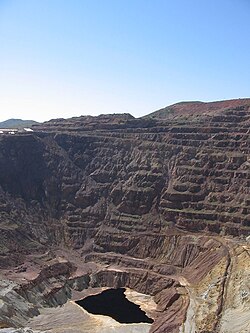
The Lavender Pit, an open pit en:copper mine, en:Bisbee, Arizona. taken by me, Sept. 30, 2006
Autor/Urheber: Adbar, Lizenz: CC BY-SA 3.0
Arizona State Road 80 between Tombstone and Bisbee, seen towards south.
Autor/Urheber: Arkyan, Lizenz: CC BY-SA 3.0
Map of Arizona State Route 80.


