Arizona State Route 347
 | |
|---|---|
| Karte | |
 | |
| Basisdaten | |
| Gesamtlänge: | 28,5 mi/45,9 km |
| Anfangspunkt: | |
| Endpunkt: | |
| Countys: | Pinal County Maricopa County |
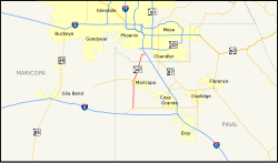
Die Arizona State Route 347 (kurz AZ 347) ist eine in Nord-Süd-Richtung verlaufende State Route im US-Bundesstaat Arizona.
Die State Route beginnt an der Arizona State Route 84 westlich von Stanfield und endet nach 46 Kilometern nordwestlich von Sun Lakes an der Interstate 10.
Nach der Abzweigung von der AZ 84 verläuft die State Route 347 bis zur Stadt Maricopa in Richtung Norden. Innerhalb des Ortes zweigt die Arizona State Route 238 in westlicher Richtung ab und die AZ 347 führt anschließend in Richtung Nordosten. Sie endet nahe dem Gila River Memorial Airport an der Interstate 10
Siehe auch
Weblinks
- Rocky Mountain Roads (englisch)
- Arizona Roads (englisch)
Auf dieser Seite verwendete Medien
30 in by 24 in (750 mm by 600 mm) Arizona State Route shield, made to the specifications of the sign detail. Uses the Roadgeek 2005 fonts. (United States law does not permit the copyrighting of typeface designs, and the fonts are meant to be copies of a U.S. Government-produced work anyway.)
24 in by 24 in (600 mm by 600 mm) Arizona State Route shield, made to the specifications of the sign detail. Uses the Roadgeek 2005 fonts. (United States law does not permit the copyrighting of typeface designs, and the fonts are meant to be copies of a U.S. Government-produced work anyway.)
Autor/Urheber: Shereth, Lizenz: CC BY-SA 3.0
Map of Arizona State Route 347.


