Arizona State Route 287
 | |
|---|---|
| Karte | |
 | |
| Basisdaten | |
| Gesamtlänge: | 32,07 mi/51,61 km |
| Anfangspunkt: | |
| Endpunkt: | |
| County: | Pinal County |
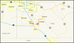
Die Arizona State Route 287 (kurz AZ 287) ist eine in Ost-West-Richtung verlaufende State Route im US-Bundesstaat Arizona.
Die State Route beginnt an der Kreuzung der Arizona State Route 84 mit der Arizona State Route 387 in Casa Grande und endet nach fast 52 Kilometern in Florence an der Arizona State Route 79.
Verlauf
Nach der Kreuzung mit den State Routes 84 und 387 im Zentrum von Casa Grande verlässt die AZ 287 der Ort in östlicher Richtung. Am östlichen Ortsausgang überquert die State Route die Interstate 10 an der Exit 194. Nach etwa 23 Kilometern trifft sie auf dem Gebiet des Ortes La Palma nordwestlich des Picacho Reservoirs auf die Arizona State Route 87, die zusammen mit der AZ 287 bis zum Casa Grande Ruins National Monument im Norden von Coolidge eine gemeinsame Trasse nutzen. Die State Route 287 verlässt Coolidge in Richtung Osten und endet nach insgesamt 51,6 Kilometern im Süden von Florence an der Arizona State Route 79.
Siehe auch
Weblinks
Auf dieser Seite verwendete Medien
Autokreuzung (Icon) in grün.
30 in by 24 in (750 mm by 600 mm) Arizona State Route shield, made to the specifications of the sign detail. Uses the Roadgeek 2005 fonts. (United States law does not permit the copyrighting of typeface designs, and the fonts are meant to be copies of a U.S. Government-produced work anyway.)
30 in by 24 in (750 mm by 600 mm) Arizona State Route shield, made to the specifications of the sign detail. Uses the Roadgeek 2005 fonts. (United States law does not permit the copyrighting of typeface designs, and the fonts are meant to be copies of a U.S. Government-produced work anyway.)
24 in by 24 in (600 mm by 600 mm) Arizona State Route shield, made to the specifications of the sign detail. Uses the Roadgeek 2005 fonts. (United States law does not permit the copyrighting of typeface designs, and the fonts are meant to be copies of a U.S. Government-produced work anyway.)
Autor/Urheber: Shereth, Lizenz: CC BY-SA 3.0
Map of Arizona State Route 287.
24 in by 24 in (600 mm by 600 mm) Arizona State Route shield, made to the specifications of the sign detail. Uses the Roadgeek 2005 fonts. (United States law does not permit the copyrighting of typeface designs, and the fonts are meant to be copies of a U.S. Government-produced work anyway.)
24 in by 24 in (600 mm by 600 mm) Arizona State Route shield, made to the specifications of the sign detail. Uses the Roadgeek 2005 fonts. (United States law does not permit the copyrighting of typeface designs, and the fonts are meant to be copies of a U.S. Government-produced work anyway.)


