Arizona State Route 187
 | |
|---|---|
| Karte | |
 | |
| Basisdaten | |
| Gesamtlänge: | 5,43 mi/ 8,74 km |
| Eröffnung: | 1944 |
| Anfangspunkt: | an der |
| Endpunkt: | an der |
| County: | Pinal County |
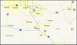
Die Arizona State Route 187 (kurz AZ 187) ist eine State Route im US-Bundesstaat Arizona, die in Nord-Süd-Richtung verläuft.
Die State Route beginnt an der Arizona State Route 387 nördlich von Casa Grande und endet nach 8,7 Kilometern nahe Sacaton an der Arizona State Route 87. Sie führt durch das Gila River Indian Reservation und sie wird oft als Abkürzung für den Verkehr in Richtung Phoenix genutzt, wenn die Interstate 10 in diese Richtung gesperrt ist.
Bis 1984 gehörte die heutige Strecke der AZ 387 zwischen der I-10 und Casa Grande noch zur AZ 187.[1]
Siehe auch
Weblinks
Einzelnachweise
- ↑ Arizona Highway Data: ADOT Right-of-Way Resolutions 1944-P-009, 1984-12-A-085, aufgerufen am 8. Februar 2011
Auf dieser Seite verwendete Medien
30 in by 24 in (750 mm by 600 mm) Arizona State Route shield, made to the specifications of the sign detail. Uses the Roadgeek 2005 fonts. (United States law does not permit the copyrighting of typeface designs, and the fonts are meant to be copies of a U.S. Government-produced work anyway.)
30 in by 24 in (750 mm by 600 mm) Arizona State Route shield, made to the specifications of the sign detail. Uses the Roadgeek 2005 fonts. (United States law does not permit the copyrighting of typeface designs, and the fonts are meant to be copies of a U.S. Government-produced work anyway.)
24 in by 24 in (600 mm by 600 mm) Arizona State Route shield, made to the specifications of the sign detail. Uses the Roadgeek 2005 fonts. (United States law does not permit the copyrighting of typeface designs, and the fonts are meant to be copies of a U.S. Government-produced work anyway.)
Autor/Urheber: Shereth, Lizenz: CC BY-SA 3.0
Map of Arizona State Route 187.


