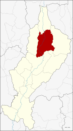
Amphoe Chae Hom
| Chae Hom แจ้ห่ม | |
|---|---|
| Provinz: | Lampang |
| Fläche: | 1349,121 km² |
| Einwohner: | 40.575 (2013) |
| Bev.dichte: | 31,5 E./km² |
| PLZ: | 52120 |
| Geocode: | 5206 |
| Karte | |
 | |

Amphoe Chae Hom (Thaiอำเภอ แจ้ห่ม, Aussprache:ʔāmpʰɤ̄ː tɕɛ̂ː hòm) ist ein Landkreis (Amphoe – Verwaltungs-Distrikt) im Norden der Provinz Lampang. Die Provinz Lampang liegt in der Nordregion von Thailand.
Geographie
Benachbarte Landkreise (von Norden im Uhrzeigersinn): die Amphoe Wang Nuea, Ngao, Mae Mo, Mueang Lampang und Mueang Pan der Provinz Lampang.
Der Chae-Son-Nationalpark (Thai:อุทยานแห่งชาติแจ้ซ้อน) liegt zum Teil im Landkreis Chae Hom.
Durch den Landkreis fließt der Mae Nam Wang (Wang-Fluss).
Verwaltung
Provinzverwaltung
Der Landkreis Chae Hom ist in sieben Tambon („Unterbezirke“ oder „Gemeinden“) eingeteilt, die sich weiter in 64 Muban („Dörfer“) unterteilen.
| Nr. | Name | Thai | Muban | Einw.[1] |
|---|---|---|---|---|
| 1. | Chae Hom | แจ้ห่ม | 11 | 8.205 |
| 2. | Ban Sa | บ้านสา | 10 | 5.090 |
| 3. | Pong Don | ปงดอน | 8 | 4.842 |
| 4. | Mae Suk | แม่สุก | 12 | 7.187 |
| 5. | Mueang Mai | เมืองมาย | 6 | 3.346 |
| 6. | Thung Phueng | ทุ่งผึ้ง | 6 | 4.056 |
| 7. | Wichet Nakhon | วิเชตนคร | 11 | 7.849 |
Lokalverwaltung
Es gibt drei Kommunen mit „Kleinstadt“-Status (Thesaban Tambon) im Landkreis:
- Chae Hom (Thai:เทศบาลตำบลแจ้ห่ม) bestehend aus Teilen des Tambon Chae Hom.
- Ban Sa (Thai:เทศบาลตำบลบ้านสา) bestehend aus dem kompletten Tambon Ban Sa.
- Thung Phueng (Thai:เทศบาลตำบลทุ่งผึ้ง) bestehend aus dem kompletten Tambon Thung Phueng.
Außerdem gibt es fünf „Tambon-Verwaltungsorganisationen“ (องค์การบริหารส่วนตำบล – Tambon Administrative Organizations, TAO)
- Chae Hom (Thai:องค์การบริหารส่วนตำบลแจ้ห่ม) bestehend aus Teilen des Tambon Chae Hom.
- Pong Don (Thai:องค์การบริหารส่วนตำบลปงดอน) bestehend aus dem kompletten Tambon Pong Don.
- Mae Suk (Thai:องค์การบริหารส่วนตำบลแม่สุก) bestehend aus dem kompletten Tambon Mae Suk.
- Mueang Mai (Thai:องค์การบริหารส่วนตำบลเมืองมาย) bestehend aus dem kompletten Tambon Mueang Mai.
- Wichet Nakhon (Thai:องค์การบริหารส่วนตำบลวิเชตนคร) bestehend aus dem kompletten Tambon Wichet Nakhon.
Einzelnachweise
- ↑ Einwohnerstatistik 2013 (Thai) Department of Provincial Administration. Abgerufen am 27. Oktober 2014.
Weblinks
- Informationen über den Chae-Son-Nationalpark (in Englisch)
- Weitere Informationen zu Amphoe Chae Hom von amphoe.com (in Thai)
Koordinaten: 18° 43′ N, 99° 33′ O
Auf dieser Seite verwendete Medien
Autor/Urheber: Takeaway, Lizenz: CC BY-SA 3.0
Panoramic view towards the southwest of the Wang River valley in Chae Hom district, just north of the city of Lampang, and the mountains of the Phi Pan Nam Range in the distance, as seen from road 1252 in Mueang Pan district in the mountains of the Khun Tan Range. Towards the left of the image, in the distance, is the main reservoir of the Mae Wang River.
Autor/Urheber: Photon34, Lizenz: CC BY-SA 3.0
Lanna script – Chae Hom is a district (amphoe) of Lampang Province, northern Thailand.
Autor/Urheber: Hdamm, Lizenz: CC BY-SA 3.0
Map of Lampang Province, Thailand, highlighting the district Chae Hom (อำเภอแจ้ห่ม)


