Amery-Schelfeis
Koordinaten: 69° 30′ S, 73° 30′ O

Das Amery-Schelfeis (englisch Amery Ice Shelf) ist eine in Ostantarktika gelegene, permanente Eisfläche, die die Prydz Bay überspannt. Es bildet sich aus den Eisflächen des Lambertgletschers, der dort in das Meer mündet. Geographisch gesehen liegt es zwischen 69° und 70° S sowie zwischen 72° und 75° O. vor Mac-Robertson-Land und Prinzessin-Elisabeth-Land. Das Amery-Schelfeis befindet sich in einer zulaufenden Bucht mit einer Länge von 400 km und einer Breite von maximal 175 km. Im Osten liegt das Amerikanische Hochland. Nördlich liegt die Kooperationssee.
Nach dem Ross-Schelfeis und dem Filchner-Ronne-Schelfeis ist es mit einer Fläche von 62.600 km2 (Stand 2007) das drittgrößte seiner Art in der Antarktis.[1]
Der australische Anspruch auf das Gebiet wurde durch den Antarktisvertrag ausgesetzt.
Vom Amery-Schelfeis löst sich ungefähr alle 60 bis 70 Jahre ein großer Eisberg ab. Zuletzt geschah dies im September 2019; die abgebrochene Eisfläche war diesmal ca. 50 × 30 Kilometer groß und 200 Meter dick; dies entspricht der Größe des Stadtgebiets von London.[2]
 Amery-Schelfeis (Satellitenaufnahme)
 Amery-Schelfeis (Animation)
Weblinks
- Ice Shelves Webseite des National Snow and Ice Data Center
- Lambert Glacier/Amery Ice Shelf Satellitenaufnahme
Einzelnachweise
- ↑ Scambos, T.A. et al., "MODIS-based Mosaic of Antarctica (MOA) data sets: Continent-wide surface morphology and snow grain size" ( vom 27. Oktober 2011 im Internet Archive)
- ↑ Riesiger Eisberg D28 abgebrochen. In: tagesschau.de. 1. Oktober 2019, archiviert vom am 1. Oktober 2019; abgerufen am 1. Oktober 2019.
Auf dieser Seite verwendete Medien

Autor/Urheber: Alexrk2, Lizenz: CC BY-SA 3.0
Physische Positionskarte Antarktis, Mittabstandstreue Azimutalprojektion
NASA Landsat map of the region around the Lambert glacier in Antarctica


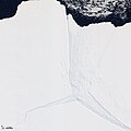
Several glaciers in East Antarctica, including the Lambert Glacier, share the same route to the ocean through the Amery Ice Shelf. Although comprising just a tiny portion of the Antarctic coastline, this ice shelf drains roughly 16 percent of the East Antarctic Ice Sheet. The Amery deposits ice into the ocean through the natural, cyclical process of iceberg calving—a process that can take decades to complete.
The Advanced Land Imager (ALI) on NASA’s Earth Observing-1 (EO-1) satellite captured this natural-color image on January 27, 2012. It shows a portion of the Amery Ice Shelf, where three giant cracks, or rifts, meet. The largest rift runs in the same direction as the ice flow, and widens toward the edge of the ice shelf (image center). Smaller rifts extend toward the east and west, and the tip of the western rift narrows and curves significantly (image lower left).
These rifts lie along the western edge of a feature glaciologists have nicknamed Amery’s “loose tooth.” The tooth is a giant tabular iceberg that has been gradually loosening for more than a decade. The overall cycle of iceberg calving on the Amery Ice Shelf is slow, with the last major calving event occurring in the early 1960s. At that time, Amery released an ice island measuring roughly 140 by 70 kilometers.
Although slow calving of icebergs has been the norm for the ice shelf, a rapid retreat is possible. Although much smaller than Antarctica’s largest ice shelves—the Ross and Filchner-Ronne—the Amery lies several degrees closer to the Equator. It also has some of the same traits as ice shelves that have retreated on the Antarctic Peninsula, such as extensive crevasses (cracks) and annual surface melt streams