American Fork Railroad
| American Fork Railroad | |||||||||||||||||
|---|---|---|---|---|---|---|---|---|---|---|---|---|---|---|---|---|---|
 American Fork Canyon, 1876: 1. Mt. Aspinwall oder Lone Mountain. 2. Bergspitzen. 3. Picnic Grove, Deer Creek. | |||||||||||||||||
| Streckenlänge: | 26 km | ||||||||||||||||
| Spurweite: | 914 mm (engl. 3-Fuß-Spur) | ||||||||||||||||
| Maximale Neigung: | 56 ‰ | ||||||||||||||||
| |||||||||||||||||
Die American Fork Railroad war eine 26 km lange Schmalspurbahn mit einer Spurweite von 3 Fuß (914 mm) von American Fork nach Forest City in Utah, die 1872–1878 betrieben wurde.
Gründung
Die American Fork Railroad wurde von New Yorker Geschäftsleuten am 3. April 1872 als Tochterfirma der Miller Mining and Smelting Company gegründet und die Gründungspapiere wurden am 16. April 1872 beim Auditor of Public Accounts eingereicht. Sie wurde von Major Edmund Wilkes aus Salt Lake City geleitet, der auch die Bergbaugesellschaft leitete.[1]
Die Vermessung der Strecke wurde ab dem 30. April 1872 durchgeführt, und die Trassierung begann am 3. Juni 1872. Am 14. Juli 1872 waren genug Schienen für etwa 11 Kilometer Gleis und 10 Flachwagen eingetroffen, aber die Gleisverlegung begann erst am 22. Juni 1872.[1]
Streckenbau

Ursprünglich war geplant, dass eine 32 km lange Strecke von einem Bahnhof an der noch zu bauenden Utah Southern, in der Nähe von American Fork City, bis zur Sultana Smelter führen sollte, die oberhalb des Fork Canyon lag. Die Trasse der Eisenbahn, sollte von einer Umladestation in American Fork an der Utah Southern, dem American Fork River nach Norden und später Nordosten folgen, und dann durch den American Fork Canyon führen. An der Stelle, an der sich der Canyon nach Nordosten und Südosten gabelt, folgte die Eisenbahn dem nordöstlichen Zweig hinauf und sollte, bis zur Sultana Smelter zu der Stelle in Forest City führen, die jetzt Dutchman Flat genannt wird. Die Strecke überwand einen Höhenunterschied von 580 m (1900 Fuß) und war stellenweise ungewöhnlich steil: Auf den Steilstrecken überwand sie als Adhäsionsbahn mit 56 ‰ einen Höhenunterschied 56 Meter pro Kilometer (296 Fuß pro Meile).[1]
Die Trassierung wurde bis Forest City fertiggestellt, aber die Gleise wurden bis zum 29. September 1872 nur bis zum Deer Creek verlegt, der etwa 6,5 Kilometer unterhalb der Gold- und Silberhütte liegt, wo heute ein kleiner Stausee ist. Ein paar Tage zuvor war die Bahnstrecke der Utah Southern bis Lehi fertiggestellt worden, etwa 4,8 Kilometer nordwestlich von American Fork. Die Utah Southern entschied sich, sie vorerst nicht weiter zu verlängern. Daraufhin vereinbarten die Utah Southern und die American Fork Railroad, dass die American Fork Railroad ihre Schmalspurgleise auf der Trasse der Utah Southern verlegen dürfe. Dies dauerte bis September 1873, aber bereits kurz danach wurde die Strecke umgespurt, als Utah Southern weiter in Richtung Süden bis American Fork verlängert wurde.[1]
Betrieb
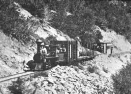
Der Betrieb der Eisenbahn erzielte keinen wirtschaftlichen Erfolg. Die ursprünglich versuchsweise eingesetzte Mason-Dampflokomotive, die nur 14 oder 15 Tonnen wog, war für die Aufgabe ungeeignet. Daher wurden Pferde und Maultiere genutzt, um die leeren Wagen den Berg hinauf zu ziehen. Bergab fuhren sie gebührlich gebremst nur durch die Schwerkraft angetrieben.[1]
Die Strecke wurde in der Sommersaison 1875 nur montags, mittwochs und freitags und im Winter gar nicht betrieben. Da das Verkehrsaufkommen der Bergbaubetriebe geringer als prognostiziert war, wurden Ausflugsfahrten für Touristen angeboten.[2] Dennoch war der Betrieb unwirtschaftlich, so dass der Betrieb eingestellt wurde und die Gleise im späten Frühjahr und Frühsommer 1878 abgerissen wurden. Die Deseret Evening News kommentierten den Streckenabbau, indem sie am 5. Juni 1878 irrtümlicherweise prognostizierten, dass der Canyon in Zukunft wohl kaum von Touristen besucht werde (the canyon “...is not likely to be visited in future, to any extent, by tourists”), was sich aber durch den zunehmenden Autotourismus nicht bewahrheitet hat. Die Schienen und Wagen wurden wohl an Charles W. Scofield, den Besitzer der Bingham Canyon Railroad der Camp Floyd Railroad und der Wasatch & Jordan Valley Railroad verkauft, der sie im August 1878 für den Bau der Utah & Pleasant Valley Railroad einsetzte.[1]
Lokomotiven
.jpg)
| Nr. | Hersteller | Achsfolge | Werks-Nr. | Baujahr | Zylinder | Räder | Gewicht | Bemerkungen |
|---|---|---|---|---|---|---|---|---|
| Erste AFRR Nr. 1 | Mason | 0-4-4T | 461 | 1. Juli 1872 | 10x15" | 33" | 13,5 t | Etwa Dezember 1873 an Eureka & Palisade Railroad verkauft. Im Okt. 1879 an Nevada Central Railroad verkauft. Im Dezember 1882 an Utah & Northern Railroad verkauft. 1886 verschrottet. |
| Zweite AFRR Nr. 2 | Porter | 0-6-0 | 151 | 30. April 1874 | 12x16" | 33" | 20 t | Ende 1878 mit Wagen und Schienen an Utah & Pleasant Valley Railroad verkauft. |
Mason-Lokomotive
American Fork Canyon
Hanging Rock

Altes Sägewerk
Hütte bei Tibble Fork
.jpg)
Einzelnachweise
- ↑ a b c d e f Don Strack: American Fork Railroad (1872–1878). 7. Juni 2013. Abgerufen am 21. September 2018.
- ↑ The American Fork Canon. In: The Pacific tourist: Williams’ illustrated trans-continental guide of travel, from the Atlantic to the Pacific Ocean. 1876. S. 143–148.
Weblinks
Koordinaten: 40° 31′ 40″ N, 111° 36′ 10″ W
Auf dieser Seite verwendete Medien
Photo of William Mason's 'Onward' in early 1872, later renamed and sold to American Fork Railroad (Arthur W Wallace Collection)

Autor/Urheber: user:Natural RX, Lizenz: CC0
bridge over double water straight (small)
Autor/Urheber: Internet Archive Book Images, Lizenz: No restrictions
Identifier: pacifictouristwi00will (find matches)
Title: The Pacific tourist : Williams' illustrated trans-continental guide of travel, from the Atlantic to the Pacific Ocean : containing full descriptions of railroad routes across the continent, all pleasure resorts and places of most noted scenery in the far West, also of all cities, towns, villages, U.S. Forts, springs, lakes, mountains, routes of summer travel, best localities for hunting, fishing, sporting, and enjoyment, with all needful information for the pleasure traveler, miner, settler, or business man : a complete traveler's guide of the Union and Central Pacific Railroads and all points of business or pleasure travel to California, Colorado, Nebraska, Wyoming, Utah, Nevada, Montana, the mines and mining of the territories, the lands of the Pacific Coast, the wonders of the Rocky Mountains, the scenery of the Sierra Nevadas, the Colorado mountains, the big trees, the geysers, the Yosemite, and the Yellowstone
Year: 1877 (1870s)
Authors: Williams, Henry T
Subjects: Union Pacific Railroad Company Central Pacific Railroad Company
Publisher: New York : H.T. Williams
Contributing Library: Harold B. Lee Library
Digitizing Sponsor: Brigham Young University
View Book Page: Book Viewer
About This Book: Catalog Entry
View All Images: All Images From Book
Click here to view book online to see this illustration in context in a browseable online version of this book.
Text Appearing Before Image:
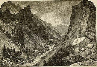
ith narrow gauge cars and locomotive.If the party is large enough lor a picnic, so muchthe better, as often flat cars are added, neatlytrimmed with evergreen boughs. The railroad,after leaving the station turns directly towardthe mountain range, and gradually ascends forthe first six miles, a steady grade of 200 feet tothe mile, until just before the mouth of the can-on it reaches 296 feet. Nothing can describe theapparent desolation of sage brush and dry sterileappearance of the soil, but here and there when-ever the little mountain brook can be divertedfrom its course, and its water used to irrigate theland, the richest of fruit trees, grass and grainspring up and give abundant crops. The littlestream, with its rapid fall, follows us up theentire length of the canon. The upward ascentof the grade seems hardly noticeable, of so uni-form a slope is the surface of the country, and itis not till the base of the mountains is reached,and the tourist looks back, he realizes his height, 144
Caption:
AMERICAN FORK CANON. BY THOMAS MORAN.
Text Appearing After Image:
O M 2 O cc <j g-4 and sees in the distance the clear surface of UtahLake considerably below him. Gathering nowon the flat cars—where the scenery can be bestobserved—the little train slowly enters the canon.Scarcely 500 feet are passed over before therebursts upon the eye views of rock scenes of themost rugged character. The little valley isscarcely 100 feet broad, and in its widest partnot over 200 feet, but from the very track and littlestream, the rocks loom up into heights of start-ling distinctness and almost perpendicular ele-vation. The color of the rocks is uniformly of verydark red and brown granite, apparently havingonce been heated in a terrible furnace, and thenin melting had arranged themselves into ruggedand fantastic shape more than mortal could con-ceive. At the beginning of the canon, the rocks aver-age about 800 feet in height, then, as the routeascends, the sides become more and more boldand erect,—the height greater, and the summitssticking up in jagged poi
Note About Images
Identifier: pacifictouristwi00will (find matches)
Title: The Pacific tourist : Williams' illustrated trans-continental guide of travel, from the Atlantic to the Pacific Ocean : containing full descriptions of railroad routes across the continent, all pleasure resorts and places of most noted scenery in the far West, also of all cities, towns, villages, U.S. Forts, springs, lakes, mountains, routes of summer travel, best localities for hunting, fishing, sporting, and enjoyment, with all needful information for the pleasure traveler, miner, settler, or business man : a complete traveler's guide of the Union and Central Pacific Railroads and all points of business or pleasure travel to California, Colorado, Nebraska, Wyoming, Utah, Nevada, Montana, the mines and mining of the territories, the lands of the Pacific Coast, the wonders of the Rocky Mountains, the scenery of the Sierra Nevadas, the Colorado mountains, the big trees, the geysers, the Yosemite, and the Yellowstone
Year: 1877 (1870s)
Authors: Williams, Henry T
Subjects: Union Pacific Railroad Company Central Pacific Railroad Company
Publisher: New York : H.T. Williams
Contributing Library: Harold B. Lee Library
Digitizing Sponsor: Brigham Young University
View Book Page: Book Viewer
About This Book: Catalog Entry
View All Images: All Images From Book
Click here to view book online to see this illustration in context in a browseable online version of this book.
Text Appearing Before Image:
Caption:
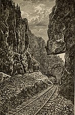
SCENES IN AMERICAN FORK CANON.
1.Mt. Aspinwall, or Lone Mountain. 2.Rock Summits. 3. Picnic Grove, Deer Creek.
4. A quiet Glen. 5. Hanging Rock. 6. Rock Narrows.
Text Appearing After Image:
Note About Images

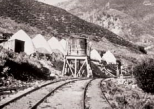
American Fork Railroad tracks at smelter at Tibble Fork ca 1870s
Sultana Smelter at the head of Mary Ellen Gulch in 1872

Identifier: pacifictouristwi00will (find matches)
Title: The Pacific tourist : Williams' illustrated trans-continental guide of travel, from the Atlantic to the Pacific Ocean : containing full descriptions of railroad routes across the continent, all pleasure resorts and places of most noted scenery in the far West, also of all cities, towns, villages, U.S. Forts, springs, lakes, mountains, routes of summer travel, best localities for hunting, fishing, sporting, and enjoyment, with all needful information for the pleasure traveler, miner, settler, or business man : a complete traveler's guide of the Union and Central Pacific Railroads and all points of business or pleasure travel to California, Colorado, Nebraska, Wyoming, Utah, Nevada, Montana, the mines and mining of the territories, the lands of the Pacific Coast, the wonders of the Rocky Mountains, the scenery of the Sierra Nevadas, the Colorado mountains, the big trees, the geysers, the Yosemite, and the Yellowstone
Year: 1877 (1870s)
Authors: Williams, Henry T
Subjects: Union Pacific Railroad Company Central Pacific Railroad Company
Publisher: New York : H.T. Williams
Contributing Library: Harold B. Lee Library
Digitizing Sponsor: Brigham Young University
View Book Page: Book Viewer
About This Book: Catalog Entry
View All Images: All Images From Book
Click here to view book online to see this illustration in context in a browseable online version of this book.
Text Appearing Before Image:
Caption:
THE OLD MILL, AMERICAN FORK CANON.
Text Appearing After Image:
THE OLD MILL, AMERICAN FORK CANON.
Note About Images

Locomotive in American Fork Canyon ca 1870s
.jpg)
Autor/Urheber: Crofutt, George A, Lizenz: No restrictions
Identifier: crofuttsnewoverl1879crof (find matches)
Title: Crofutt's new overland tourist and Pacific coast guide : containing a condensed and authentic description of over one thousand two hundred cities, towns, villages, stations, government fort and camps, mountains, lakes, rivers, sulphur, soda and hot springs, scenery, watering places, and summer resorts : where to look for and hunt the buffalo, antelope, deer and other game; trout fishing, etc., etc. In fact, to tell you what is worth seeing--where to see it--where to go--how to go--and whom to stop with while passing over the Union, Central and Southern Pacific Railroads, their branches and connections, by rail, water and stage, from sunrise to sunset, and part the way back, through Nebraska, Wyoming, Colorado, Utah, Montana, Idaho, Nevada, California and Arizona
Year: 1879 (1870s)
Authors: Crofutt, George A
Subjects:
Publisher: Chicago, Ill., The Overland Pub. Co.
Contributing Library: Harold B. Lee Library
Digitizing Sponsor: Brigham Young University
View Book Page: Book Viewer
About This Book: Catalog Entry
View All Images: All Images From Book
Click here to view book online to see this illustration in context in a browseable online version of this book.
Text Appearing Before Image:
heCentral Vermont and the Grand Trunk. From Boston there are quite a num-ber of lines. One, as above described, isthrough Vermont and Canada; another isby the Boston & Albany railroad to Al-bany, where connections are made withroute 2; another is the new Hoosac Tun-nel route, through the mountain and tun-nel of that name,—25,081 feet in length,double track; cost $16,000,000—cut througha mountain which iises 1,900 feet above thetrack. This route is a very desirable one,passes through the entire length of theState of Massachusetts, and connects withroute 2, at Troy, New York. Anotherline is via Springfield, or Shore Line, toNew York city; or, you can take part*rail and the steamships on Long IslandSound, of which there are three first-classlines, comprising some of the finest boatsin the world. From New York city, passengers whodesire to visit NiAOARA-whose thimderingcataracts, in volume of waters, far surpassall other waterfalls in the known world— AND PACIFIC COAST GUIDE. 15
Text Appearing After Image:
HANGING ROCX, AMERICAN FORK R.R., UTAH See Annex No. 18-. may also view the great Suspension Bridgeover Niagara River, which, undoubtedly, isone of the finest structures of its kind inthis country. They can have choice of twotrunk lines. Route 2.—The New York Central &Hudson River line, passes up the gloriousold Hudson, the magnificent river upon thebosom of which Fulton launched his *ex-periment, the first steamboat ever con-structed. This road is built almost on theriver brink, upon the eastern bank, which slopes back in irregu-lar terraces, presentingfrom the car windowone of the finest, if notthe finest, panoramicview in the world.On the right are manysmall cities, towns andvillages, with groves,parks, gardens, orch-ards, and alternate richfields, with here andthere, peeping out frombeneath the trees, themagnificent countryvilla of the nabob,the substantial resi-dence ot the wealthymerchant, or the neatand tasteful cottage ofthe well-to-do farmer.Then come the Pali-sades of
Note About Images