Alutu
| Alutu | ||
|---|---|---|
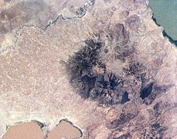
 Satellitenbild des Alutu | ||
| Höhe | 2335 m | |
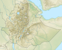
| Lage | Äthiopien | |
| Koordinaten | 7° 46′ 12″ N, 38° 46′ 48″ O | |
| ||
| Typ | Stratovulkan | |
| Letzte Eruption | ca. 50 v. Chr. | |
Alutu ist ein 2335 Meter hoher Schichtvulkan in Äthiopien. Er liegt zwischen den beiden Seen Zway und Mirrga (Langano) und besteht aus mehreren Schloten entlang einer Ausrichtung von Nordnordost nach Südsüdwest. Es entstanden rhyolithische und Obsidian-Lavaströme, welche sich über alle Flanken ergossen. Die älteste datierte Eruption des Vulkans fand vor 155.000 Jahren statt. Der letzte Ausbruch vor etwa 2.000 Jahren ließ Obsidian-Lavaströme entstehen. Bis heute ist eine starke Fumarolen-Aktivität zu verzeichnen. Der Vulkan war Gegenstand eines geothermischen Forschungsprogramms.
Weblinks
- Alutu im Global Volcanism Program der Smithsonian Institution (englisch)
Auf dieser Seite verwendete Medien
Alutu volcano lies between light-brown Lake Mirrga (Lake Langano) on the south and greenish Lake Zway on the north. The volcano displays several craters aligned along NNE-SSW and E-W fissures. Dark-colored obsidian lava flows erupted from craters along the fissures have descended the flanks in all directions. Although the age of the most recent eruption of Alutu is not known, its eruptive products overlie recent basaltic lava flows to the west, and strong fumarolic activity continues.
(c) Karte: NordNordWest, Lizenz: Creative Commons by-sa-3.0 de
Positionskarte von Äthiopien


