Alid
| Alid | ||
|---|---|---|
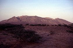
 Alid von Westen aus gesehen | ||
| Höhe | 904 m | |
| Lage | Eritrea | |
| Koordinaten | 14° 53′ 0″ N, 39° 55′ 0″ O | |
| Typ | Schichtvulkan | |
Alid ist ein isolierter, zergliederter Vulkan in der Danakil-Senke in Eritrea. Seine Höhe beträgt 904 Meter. Durch rhyolithische Eruptionen im späten Pleistozän wurden große Mengen an Asche ausgeworfen. Ein 2 Kilometer mal 3 Kilometer messender Grabenbruch durchschneidet den Lavadom. Kleine Kegel und Krater entlang nordnordwestlich verlaufender Spalten zeigen den Ursprung großer Lavaströme. Nahe dem nördlichen Gipfel und der Flanke zeigt sich nach wie vor Fumarolen-Aktivität.
Weblinks
- Alid im Global Volcanism Program der Smithsonian Institution (englisch)
Auf dieser Seite verwendete Medien
The elongated Alid volcano, which sits on the axis of the Danakil spreading center, is seen here from the west. Most of the flanks of the volcano in this view are composed of dipping rhyolitic lava flows; the light-colored area along the right skyline is rhyolitic pumice. The summit of the volcano is elongated in an E-W direction and contains a 1 x 1.5 km wide, 100-m-deep crater at the western end. Vast lava fields originating from fissure vents in the Alid graben extend to the NW and SE of the volcano. Vigorous fumarolic activity continues at Alid.
Autor/Urheber: Urutseg, Lizenz: CC0
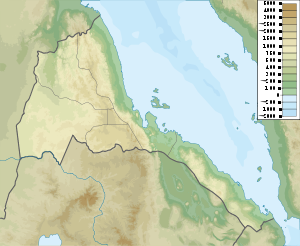
Eritrea physical map, parameters equal to File:Eritrea location map.svg


