Algoa Bay
| Algoa-Bucht Algoa Bay | ||
|---|---|---|
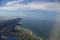
Algoa Bay, im Vordergrund Gqeberha | ||
| Gewässer | Indischer Ozean | |
| Landmasse | Provinz Ostkap, | |
| Geographische Lage | 33° 50′ 0″ S, 25° 50′ 0″ O | |
| Inseln | St. Croix Islands, Bird Islands | |
 Karte der Algoa-Bucht aus dem 17. Jahrhundert | ||

Die Algoa-Bucht ist eine Bucht in der Provinz Ostkap, Südafrika. Sie liegt etwa 683 km östlich vom Kap der Guten Hoffnung. Die größte Stadt an der Bucht ist Gqeberha.
Inseln
In der Bucht befinden sich zwei Inselgruppen.
Zu den St. Croix Islands gehören:
- St. Croix Island
- Brenton Island
- Jahleel Island
Zu den Bird Islands zählen:
- Bird Island
- Seal Island
- Stag Island
Weblinks
Auf dieser Seite verwendete Medien
Verwendete Farbe: National flag | South African Government and Pantone Color Picker
| Grün | gerendert als RGB 0 119 73 | Pantone 3415 C |
| Gelb | gerendert als RGB 255 184 28 | Pantone 1235 C |
| Rot | gerendert als RGB 224 60 49 | Pantone 179 C |
| Blau | gerendert als RGB 0 20 137 | Pantone Reflex Blue C |
| Weiß | gerendert als RGB 255 255 255 | |
| Schwarz | gerendert als RGB 0 0 0 |
Autor/Urheber: Htonl, Lizenz: CC BY-SA 3.0
Relief location map of the Eastern Cape
Equirectangular projection, N/S stretching 117%. Geographic limits of the map:
- N: 29.75° S
- S: 34.5° S
- W: 22.5° E
- E: 30.5° E
(c) Socrates2008 at en.wikipedia, CC BY 3.0
Algoa Bay with Port Elizabeth in the foreground.
"The British Settlers of 1820 Landing in Algoa Bay", by Thomas Baines, 1853
Title in the Leupe catalogue (NA): Kaart van de Delagaobaai.
Compass lines printed by Willem Blaeu (this printed paper was used often afther his death in 1638).
Notes on reverse: De Delagoa baai van Afrika [in pencil] / 23 [in pencil] / No. 2.


