Ajuricaba
| Ajuricaba | |||
|---|---|---|---|
| |||
| Koordinaten | 28° 14′ 29″ S, 53° 46′ 10″ W | ||
| Basisdaten | |||
| Staat | Brasilien | ||
| Bundesstaat | Rio Grande do Sul | ||
| Stadtgründung | 8. November 1965 | ||
| Einwohner | 7063 (Ber. 2018) | ||
| Stadtinsignien | |||
 |  | ||
| Detaildaten | |||
| Fläche | 322,671 | ||
| Bevölkerungsdichte | 22,9 Ew./km2 | ||
| Höhe | 336 m | ||
| Zeitzone | UTC−3 | ||
| Website | |||
 | |||
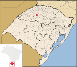
Ajuricaba ist eine Stadt im Bundesstaat Rio Grande do Sul im Süden Brasiliens. Sie liegt etwa 430 km nordwestlich von Porto Alegre.
Geographie
Benachbart sind die Orte Nova Ramada, Condor, Panambi, Bozano und Ijuí.
Geschichte
Ursprünglich war Ajuricaba Teil des Munizips Ijuí.[1]
Persönlichkeiten
- Carlos Eduardo Marques (* 1987), Fußballspieler
Weblinks
- Ajuricaba – Panorama. IBGE, abgerufen am 30. Juni 2019 (brasilianisches Portugiesisch).
- Offizielle Website der Präfektur von Ajuricaba. Abgerufen am 30. Juni 2019 (brasilianisches Portugiesisch).
- Atlas do Desenvolvimento Humano no Brasil – Ajuricaba, RS, sozialstatistische Angaben (brasilianisches Portugiesisch)
Einzelnachweise
- ↑ Ajuricaba – História. IBGE, abgerufen am 30. Juni 2019 (brasilianisches Portugiesisch).
Auf dieser Seite verwendete Medien
Autor/Urheber: Milenioscuro, Lizenz: CC BY-SA 4.0
Location map of Rio Grande do Sul state.
Flag of the city of Ajuricaba, Rio Grande do Sul, Brazil.
Coat of arms of the city of Ajuricaba, Rio Grande do Sul, Brazil.
Autor/Urheber: Raphael Lorenzeto de Abreu, Lizenz: CC BY 2.5
Map locator of Rio Grande do Sul's Ajuricaba city


