Adams National Historical Park
| Adams National Historical Park | |||
|---|---|---|---|
 (c) Daderot, CC BY-SA 3.0 | |||
| |||
| Lage: | Massachusetts, Vereinigte Staaten | ||
| Nächste Stadt: | Quincy | ||
| Fläche: | 0,1 km² | ||
| Gründung: | 9. Dezember 1946 | ||
| Besucher: | 199.301 (2016[1]) | ||
Der Adams National Historical Park ist eine Gedenkstätte zur Erinnerung an die Familie Adams, aus der zwei US-Präsidenten und mehrere weitere Politiker, Diplomaten, Militärs, Unternehmensführer und Wissenschaftler hervorgegangen sind. Der 1946 erstmals gewidmete National Historical Park liegt in Quincy im US-Bundesstaat Massachusetts, einem Vorort von Boston, und wird vom National Park Service verwaltet.
Bauwerke in der Gedenkstätte
Zum Adams National Historical Park gehören elf historische Gebäude, die mit dem Leben der Mitglieder der Familie Adams verbunden sind. Darunter:
- Das Geburtshaus von John Adams (1735–1826), der zwischen 1797 und 1801 der 2. Präsident der Vereinigten Staaten war.
- Das Geburtshaus von John Quincy Adams (1767–1848), Sohn von John Adams und von 1825 bis 1829 der 6. US-Präsident.
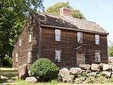
- Das Wohnhaus und Farmgebäude Peacefield, in dem John Adams und seine Frau Abigail Adams ab 1788 wohnten.
- Die Stone Library, ein Bibliotheksbau, den Charles Francis Adams, Sr. 1870 in Erfüllung einer testamentarischen Anregung seines Vaters John Quincy Adams bauen ließ. Heute enthält sie Unterlagen und rund 12.000 Bücher aus sechs Generationen der Adams.
Auf dem Gelände steht auch die United First Parish Church, eine Kirche der Unitarian Universalists, in der beide US-Präsidenten und ihre Frauen in einer Familiengruft begraben liegen. Der heutige Bau aus dem Jahr 1828 wurde von Architekt Alexander Parris errichtet. Die Kirche gehört jedoch nicht zur Gedenkstätte; sie ist im Besitz der Kirchengemeinde und wird noch heute genutzt.
 (c) Daderot, CC BY-SA 3.0
Geburtshaus von John Adams

Geburtshaus von John Quincy Adams

Die Stone Library

Der Empfangsraum in Peacefield


Zu den weiteren Angehörigen der Familie Adams, die auf dem Gelände lebten, gehören Charles Francis Adams, Sr., Sohn von John Quincy, Diplomat und US-Senator, Charles Francis Adams, Jr., Sohn von Charles Francis sr., General und Präsident der Union Pacific Railroad sowie die Brüder von Charles Francis jr., der Historiker Brooks Adams sowie der Historiker und Kulturphilosoph Henry Adams mit seiner Frau Marian Hooper Adams.
Geschichte der Gedenkstätte
Erstmals wurde ein Teil der heutigen Gedenkstätte 1946 als Adams Mansion National Historic Site gegründet. Sie wurde 1952 in Adams National Historic Site umbenannt, und 1960 wurden die beiden Geburtshäuser als National Historic Landmarks ausgewiesen. Der Gesamtkomplex wurde am 2. November 1998 in einen national historical park umgewidmet.
Weblinks
- Eintrag von John Quincy Adams’ Geburtsort im National Historic Landmarks Programm
- National Park Service: Adams National Historical Park (offizielle Seite; englisch)
Einzelnachweise
- ↑ Stats Report Viewer. National Park Service, abgerufen am 27. Dezember 2017 (englisch, unter „Park“ den passenden Eintrag auswählen).

Abraham Lincoln Birthplace | Adams | Appomattox Court House | Boston | Cane River Creole | Cedar Creek and Belle Grove | Chaco Culture | Chesapeake and Ohio Canal | Colonial | Cumberland Gap | Dayton Aviation Heritage | George Rogers Clark | Harpers Ferry | Hopewell Culture | Independence | Jean Lafitte | Kalaupapa | Kaloko-Honokōhau | Keweenaw | Klondike Gold Rush | Lewis and Clark | Lowell | Lyndon B. Johnson | Marsh-Billings-Rockefeller | Minute Man | Morristown | Natchez | New Bedford Whaling | New Orleans Jazz | Nez Perce | Palo Alto Battlefield | Paterson Great Falls | Pecos | Puʻuhonua o Hōnaunau | Rosie the Riveter/World War II Home Front | Salt River Bay | San Antonio Missions | San Francisco Maritime | San Juan Island | Saratoga | Sitka | Thomas Edison | Tumacácori | Valley Forge | War in the Pacific | Women’s Rights
Auf dieser Seite verwendete Medien
_location_map.svg)
Autor/Urheber: TUBS
Location map of the USA (Hawaii and Alaska shown in sidemaps).
Main map: EquiDistantConicProjection : Central parallel :
* N: 37.0° N
Central meridian :
* E: 96.0° W
Standard parallels:
* 1: 32.0° N
* 2: 42.0° N
Made with Natural Earth. Free vector and raster map data @ naturalearthdata.com.
Formulas for x and y:
x = 50.0 + 124.03149777329222 * ((1.9694462586094064-({{{2}}}* pi / 180))
      * sin(0.6010514667026994 * ({{{3}}} + 96) * pi / 180))
y = 50.0 + 1.6155950752393982 * 124.03149777329222 * 0.02613325650382181
      - 1.6155950752393982  * 124.03149777329222 *
     (1.3236744353715044  - (1.9694462586094064-({{{2}}}* pi / 180))
      * cos(0.6010514667026994 * ({{{3}}} + 96) * pi / 180))
Hawaii side map: Equirectangular projection, N/S stretching 107 %. Geographic limits of the map:
- N: 22.4° N
- S: 18.7° N
- W: 160.7° W
- E: 154.6° W
Alaska side map: Equirectangular projection, N/S stretching 210.0 %. Geographic limits of the map:
- N: 72.0° N
- S: 51.0° N
- W: 172.0° E
- E: 129.0° W

Autor/Urheber: en:User:Daderot, Lizenz: CC BY-SA 3.0
Birthplace of U. S. President John Quincy Adams, in Quincy, Massachusetts. This house is now part of the Adams National Historical Park operated by the National Park Service, and is open to the public.

(c) Daderot, CC BY-SA 3.0
Birthplace of U. S. President John Adams, in Quincy, Massachusetts. This house is now part of the Adams National Historical Park operated by the National Park Service, and is open to the public. Photograph taken by me, August 2005.

This is a simple dot (currently red) for overlaying on locator maps. I created this transparent GIF file myself.
Autor/Urheber: Originally uploaded English Wikipedia by en:User:Papayoung and en:User:Ilmari Karonen.
Base versions this one is derived from: originally created by en:User:Wapcaplet, Lizenz: CC BY-SA 3.0
This image is abstracted from Image:Map_of_USA_with_state_names.svg (GFDL).
(c) Daderot, CC BY-SA 3.0
The "Old House" in Quincy, Massachusetts, residence of U. S. President John Adams and his family for four generations. It was home to Adams and his wife Abigail Adams, their son President John Quincy Adams and his wife Louisa Catherine Adams, their son Charles Francis Adams (ambassador to the United Kingdom during the American Civil War), and historians Henry Adams and Brooks Adams. This house is now part of the Adams National Historical Park operated by the National Park Service, and is open to the public. Photograph taken by en:User:Daderot , August 2005.