Adams County (Wisconsin)
 | |
| Verwaltung | |
|---|---|
| US-Bundesstaat: | Wisconsin |
| Verwaltungssitz: | Friendship |
| Adresse des Verwaltungssitzes: | County Courthouse 402 Main Street Friendship, WI 53934-0278 |
| Gründung: | 11. März 1848 |
| Gebildet aus: | Portage County |
| Vorwahl: | 001 608 |
| Demographie | |
| Einwohner: | 20.654 (Stand: 2020) |
| Bevölkerungsdichte: | 12,32 Einwohner/km2 |
| Geographie | |
| Fläche gesamt: | 1783 km² |
| Wasserfläche: | 106 km² |
| Karte | |
 | |
| Website: www.co.adams.wi.gov | |
Das Adams County[2] ist ein County im US-amerikanischen Bundesstaat Wisconsin. Im Jahr 2020 hatte das County 20.654 Einwohner und eine Bevölkerungsdichte von 12,3 Einwohnern pro Quadratkilometer.[3] Der Verwaltungssitz (County Seat) ist Friendship.[4]
Geografie
Das County liegt etwas südlich des geografischen Zentrums von Wisconsin und hat eine Fläche von 1783 Quadratkilometern, wovon 106 Quadratkilometer Wasserfläche sind. Die niedrigste Stelle liegt bei 310 m und die höchste bei 415 m. Durch das County fließen der Wisconsin River und der Lemonweir River. An das Adams County grenzen an folgende Nachbarcountys:
| Wood County | Portage County | |
| Juneau County |  | Waushara County, Marquette County |
| Sauk County | Columbia County |
Geschichte

Das Adams County wurde am 11. März 1848 aus Teilen des Portage County gebildet. Benannt wurde es nach John Quincy Adams, dem sechsten Präsidenten der USA.
Bevölkerung
| Bevölkerungsentwicklung | |||
|---|---|---|---|
| Census | Einwohner | ± rel. | |
| 1900 | 9.141 | — | |
| 1910 | 8.604 | −5,9 % | |
| 1920 | 9.287 | 7,9 % | |
| 1930 | 8.003 | −13,8 % | |
| 1940 | 8.449 | 5,6 % | |
| 1950 | 7.906 | −6,4 % | |
| 1960 | 7.566 | −4,3 % | |
| 1970 | 9.234 | 22 % | |
| 1980 | 13.457 | 45,7 % | |
| 1990 | 15.682 | 16,5 % | |
| 2000 | 18.643 | 18,9 % | |
| 2010 | 20.875 | 12 % | |
| 2020 | 20.654 | −1,1 % | |
| 1900–1990[5] 2000[4] 2010–2020[3] | |||


Nach der Volkszählung im Jahr 2010 lebten im Adams County 20.875 Menschen in 9168 Haushalten. Die Bevölkerungsdichte betrug 12,4 Einwohner pro Quadratkilometer. In den 9168 Haushalten lebten statistisch je 2,12 Personen.
Ethnisch betrachtet setzte sich die Bevölkerung zusammen aus 93,9 Prozent Weißen, 3,3 Prozent Afroamerikanern, 1,1 Prozent amerikanischen Ureinwohnern, 0,4 Prozent Asiaten, 0,1 Prozent Polynesiern sowie aus anderen ethnischen Gruppen; 1,2 Prozent stammten von zwei oder mehr Ethnien ab. Unabhängig von der ethnischen Zugehörigkeit waren 3,8 Prozent der Bevölkerung spanischer oder lateinamerikanischer Abstammung.
15,7 Prozent der Bevölkerung waren unter 18 Jahre alt, 58,8 Prozent waren zwischen 18 und 64 und 25,5 Prozent waren 65 Jahre oder älter. 45,8 Prozent der Bevölkerung war weiblich.
Das jährliche Durchschnittseinkommen eines Haushalts lag bei 41.152 USD. Das Pro-Kopf-Einkommen betrug 22.296 USD. 12,4 Prozent der Einwohner lebten unterhalb der Armutsgrenze.[7]
Ortschaften im Adams County
Andere Census-designated places (CDP)
|
|
|
|
|
1 – teilweise im Columbia, Sauk und im Juneau County
Gliederung
Das Adams County ist neben den drei inkorporierten Kommunen in 17 Towns eingeteilt[8]:
|
|
|
Siehe auch
Einzelnachweise
- ↑ Auszug aus dem National Register of Historic Places - Nr. 82000627 Abgerufen am 2. August 2013
- ↑ Adams County. In: Geographic Names Information System. United States Geological Survey, United States Department of the Interior, abgerufen am 22. Februar 2011 (englisch).
- ↑ a b Eintrag bei Census.gov. Abgerufen am 26. August 2021.
- ↑ a b National Association of Counties Abgerufen am 2. August 2013
- ↑ Auszug aus Census.gov. Abgerufen am 28. Februar 2011
- ↑ Wisconsin (WI), Adams County. In: National Register of Historic Places. Abgerufen am 13. August 2024 (englisch, Auszug aus dem National Register of Historic Places - Nr. 81000031).
- ↑ U.S. Census Buero, State & County QuickFacts - Adams County, WI ( vom 6. Juni 2011 im Internet Archive)
- ↑ Missouri Census Data Center - Wisconsin ( vom 18. Januar 2016 im Internet Archive)
Weblinks
Koordinaten: 43° 58′ N, 89° 46′ W
Auf dieser Seite verwendete Medien
This is a locator map showing Adams County in Wisconsin. For more information, see Commons:United States county locator maps.
Autor/Urheber: myself, Lizenz: CC BY-SA 2.5
Looking north at Roche-a-Cri Petroglyphs at the Roche-a-Cri State Park north of Friendship, Wisconsin, in the U.S.A., & the petroglyph site is a registered historic place.
Autor/Urheber: Royalbroil, Lizenz: CC BY-SA 3.0
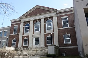
The Adams County Courthouse (Wisconsin) in Adams County, in Wisconsin & it’s listed on the National Register of Historic Places.
Autor/Urheber: myself, Lizenz: CC BY-SA 2.5
Looking north at the rock outcropping that contains the Roche-a-Cri Petroglyphs at the Roche-a-Cri State Park north of Friendship, in Wisconsin, in the U.S.A., & the petroglyph site is a registered historic place.


