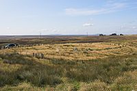
Achavanich
Achavanich (auch Achkinloch – schottisch-gälisch Achadh a’ Mhanaich) ist eine U-förmige (engl. horseshoe-shaped)[1] Steinsetzung, etwa sieben Kilometer nördlich von Latheron nahe dem See „Loch Stemster“ in Caithness in Schottland.
Es gibt heute 36 sichtbare Steine. Einzelne sind kaum mehr als einen Meter hoch. Es kann angenommen werden, erkennbar an der Verwitterung der erhaltenen Steine, dass viele einst wesentlich höher waren. Die ursprüngliche Anzahl kann etwa 54 betragen haben. Die Achse der Anlage ist SSE-NNW orientiert. Die Wirkung der an einem flachen Hang in der Heide platzierten Anlage ist beabsichtigt. Ihr Erstelldatum ist unbekannt, aber es wird davon ausgegangen, dass sie aus der Bronzezeit stammt. Setzungen dieser Art sind in Großbritannien sehr selten. Mehr Beispiele sind aus der Bretagne bekannt.
Südlich von Latheron befand sich der als Stein von Latheron bekannte Cross-Slab. Am Acharole Hill wurde die Steinkiste von Cnoc Sgadain entdeckt.
Siehe auch
- Bechergrab von Achavanich
Literatur
- Anna Ritchie: Scotland BC. An introduction to the prehistoric houses, tombs, ceremonial monuments and fortifications in the care of the Secretary of State for Scotland. H.M.S.O., Edinburgh 1988, ISBN 0-11-493427-4.
Einzelnachweise
- ↑ Eine Form, die sich bis zu den Sarsen-Steinen von Stonehenge erhalten hat.
Weblinks
- Achavanich (zuletzt abgerufen am 10. Dezember 2012)
- Eintrag zu Achavanich in Canmore, der Datenbank von Historic Environment Scotland (englisch)
Koordinaten: 58° 21′ 23,8″ N, 3° 23′ 22,7″ W
Auf dieser Seite verwendete Medien
(c) Jonathan Billinger, CC BY-SA 2.0
Achavanich Standing Stones Near Loch Stemster in Caithness is an unusual horseshoe-shaped arrangement of small standing stones. The tallest is only 2 m (6 ft 6 in) high. Some stones may have been taller, but weathering has caused them to crack and split. Only 36 stones remain in the setting, although there may have been about 54 originally.
   At most stone circles the flat faces of the stones follow the line of the setting, but at Achavanich the flat faces are 'side on'. The stone slabs appear to be set into a low mound of earth and stone, possibly the result of levelling the central area. Purpose and date of this setting are unknown, but they are usually assumed to belong to the Bronze Age.
   Outside the NE corner of the setting are some small slabs, possibly the remains of cist burials, protruding through the turf. Close to SE there's also a cairn, situated on a knoll. The fact that these later sites were built in the same area shows that the region remained one of ritual importance over the centuries.
Info supplied by; http://www.stonepages.com/


