Acadia Parish
 | |
| Verwaltung | |
|---|---|
| US-Bundesstaat: | Louisiana |
| Verwaltungssitz: | Crowley |
| Adresse des Verwaltungssitzes: | Parish Courthouse P.O. Box A Crowley, LA 70527-6001 |
| Gründung: | 30. Juni 1886 |
| Gebildet aus: | St. Landry Parish |
| Vorwahl: | 001 337 |
| Demographie | |
| Einwohner: | 57.576 (Stand: 2020) |
| Bevölkerungsdichte: | 33,93 Einwohner/km² |
| Geographie | |
| Fläche gesamt: | 1703 km² |
| Wasserfläche: | 6 km² |
| Karte | |
 | |
| Website: www.acadiaparishpolicejury.org | |

Das Acadia Parish[1] (frz.: Paroisse de l'Acadie) ist ein Parish im US-amerikanischen Bundesstaat Louisiana. Bei der Volkszählung im Jahr 2020 hatte das Parish 57.576[2] Einwohner und eine Bevölkerungsdichte von 33,9 Einwohnern pro Quadratkilometer. Der Verwaltungssitz (Parish Seat) ist Crowley.[3] Das Acadia Parish ist nach der französischen Kolonialregion in den kanadischen Seeprovinzen benannt.
Geografie
Das Parish liegt südlich des geografischen Zentrums von Louisiana und wird vom in den etwa 80 km entfernten Golf von Mexiko mündenden Mermentau River durchflossen. Es hat eine Fläche von 1703 Quadratkilometern, wovon sechs Quadratkilometer Wasserflächen sind. An das Acadia Parish grenzen folgende Nachbarparishes:
| Evangeline Parish | St. Landry Parish | |
| Jefferson Davis Parish |  | Lafayette Parish |
| Vermilion Parish |
Geschichte
Das Acadia Parish wurde am 30. Juni 1886 aus Teilen des St. Landry Parish gebildet. Benannt wurde es nach den Flüchtlingen aus Nova Scotia.
Demografische Daten
| Bevölkerungsentwicklung | |||
|---|---|---|---|
| Census | Einwohner | ± rel. | |
| 1890 | 13.231 | — | |
| 1900 | 23.483 | 77,5 % | |
| 1910 | 31.847 | 35,6 % | |
| 1920 | 34.820 | 9,3 % | |
| 1930 | 39.326 | 12,9 % | |
| 1940 | 46.260 | 17,6 % | |
| 1950 | 47.050 | 1,7 % | |
| 1960 | 49.931 | 6,1 % | |
| 1970 | 52.109 | 4,4 % | |
| 1980 | 56.427 | 8,3 % | |
| 1990 | 55.882 | −1 % | |
| 2000 | 58.861 | 5,3 % | |
| 2010 | 61.773 | 4,9 % | |
| 2020 | 57.576 | −6,8 % | |
| Vor 19000[4] 1900–1990[5] 2000[3] 2010–2012[6] | |||
Nach der Volkszählung im Jahr 2010 lebten im Acadia Parish 61.773 Menschen in 21.984 Haushalten. Die Bevölkerungsdichte betrug 36,4 Einwohner pro Quadratkilometer. In den 21.984 Haushalten lebten statistisch je 2.75 Personen.
Ethnisch betrachtet setzte sich die Bevölkerung zusammen aus 79,5 Prozent Weißen, 18,1 Prozent Afroamerikanern, 0,3 Prozent amerikanischen Ureinwohnern, 0,2 Prozent Asiaten sowie aus anderen ethnischen Gruppen; 1,3 Prozent stammten von zwei oder mehr Ethnien ab. Unabhängig von der ethnischen Zugehörigkeit waren 1,7 Prozent der Bevölkerung spanischer oder lateinamerikanischer Abstammung.
27,3 Prozent der Bevölkerung waren unter 18 Jahre alt, 59,9 Prozent waren zwischen 18 und 64 und 12,8 Prozent waren 65 Jahre oder älter. 51,2 Prozent der Bevölkerung war weiblich.
Das jährliche Durchschnittseinkommen eines Haushalts lag bei 37.261 USD. Das Prokopfeinkommen betrug 18.116 USD. 20,1 Prozent der Einwohner lebten unterhalb der Armutsgrenze.[6]
Ortschaften im Acadia Parish
|
|
Census-designated places (CDP)
- Branch
- Egan
|
|
|
|
1 – teilweise im St. Landry Parish
2 – teilweise im Evangeline Parish
3 – teilweise im Lafayette Parish
Gliederung

Das Acadia Parish ist in 8 durchnummerierte Distrikte eingeteilt:[7]
| Distrikt | Einwohner (2010) | FIPS |
|---|---|---|
| 1 | 6.397 | 22-94000 |
| 2 | 7.552 | 22-94201 |
| 3 | 7.300 | 22-94381 |
| 4 | 7.380 | 22-94567 |
| 5 | 7.524 | 22-94759 |
| 6 | 8.822 | 22-94933 |
| 7 | 8.446 | 22-95092 |
| 8 | 8.352 | 22-95242 |
Siehe auch
- Liste der Einträge im National Register of Historic Places im Acadia Parish
Einzelnachweise
- ↑ Acadia Parish. In: Geographic Names Information System. United States Geological Survey, United States Department of the Interior, abgerufen am 28. Februar 2011 (englisch).
- ↑ US Census Bureau: Search Results Total Population in Acadia Parish, Louisiana. Abgerufen am 16. Januar 2024 (amerikanisches Englisch).
- ↑ a b National Association of Counties Abgerufen am 12. August 2013
- ↑ U.S. Census Bureau _ Census of Population and Housing Abgerufen am 17. Februar 2011
- ↑ Auszug aus Census.gov Abgerufen am 17. Februar 2011
- ↑ a b U.S. Census Buero, State & County QuickFacts – Acadia Parish, LA ( vom 6. Juni 2011 im Internet Archive) Abgerufen am 12. August 2013
- ↑ Missouri Census Data Center – Louisiana (Seite nicht mehr abrufbar, festgestellt im Juni 2020. Suche in Webarchiven) Abgerufen am 8. Februar 2012.
Weblinks
- Acadia Parish Police Jury
- Acadia Parish Facts ( vom 12. Juli 2013 im Internet Archive)
- www.city-data.com – Acadia Parish
Koordinaten: 30° 16′ N, 92° 24′ W
Auf dieser Seite verwendete Medien
Autor/Urheber: David Wilson, Lizenz: CC BY 2.0
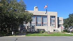
Crowley, Louisiana. Acadia Parish Courthouse.
Autor/Urheber: Ken Lund from Las Vegas, Nevada, USA, Lizenz: CC BY-SA 2.0
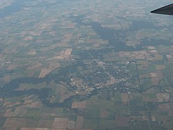
Crowley is a city in and the parish seat of Acadia Parish, Louisiana, United States.[1] The population was 14,225 at the 2000 census. The city is noted for its annual International Rice Festival. Crowley has the nickname of "Rice Capital of America", because at one time it was a major center for rice harvesting and milling. Today, Crowley still has a number of rice mills and rice is the main crop of many local farmers. In addition, in recent years, crawfish farming has become increasingly popular.
Crowley is the home of Mastertrak Studios. The studio that is now Mastertrak was founded by J. D. "Jay" Miller in 1955 and has hosted such notable recording artists as Paul Simon and John Fogerty. The studio is known for producing Swamp blues music, as well as segregationist music of the 1960s.
The Crowley High School "Fighting Gents" were District 5-3A Champs in the 1989 football season and had a 8-2 regular season. Crowley is also the home of Notre Dame High School. Notre Dame is a parish-wide Catholic school whose football program has won three state championships and numerous District Champion titles.
Crowley is the principal city of the Crowley Micropolitan Statistical Area, which includes all of Acadia Parish. It is also part of the larger Lafayette–Acadiana Combined Statistical Area.
Crowley was founded in 1886[4] by C.C. Duson and W.W. Duson. Incorporated in 1887, W.W. Duson, General Manager of Southwest Louisiana Land Company, platted and developed Crowley. W.W. Duson's daughter, Maime Duson, married P.L. Lawrence, who founded the First National Bank of Crowley. The 10 story building was once the tallest building between Houston and New Orleans. They lived with their three children, P.L. Jr., Pattee, and Jack at 219 East 2nd Street. The house is now on the historic register.
In the early 20th century, oil discoveries in Acadia Parish brought oil companies into the area looking to do business. Lafayette's Oil Center was initially planned for Crowley but the undocumented rumor is that the Lawrence family discouraged it. Another local rumor has it that The University of Louisiana - Lafayette was first offered to Crowley as well. The descendants of W.W. Duson owned much of Crowley and the surrounding land. P.L. Lawrence often walked about town and intended to keep Crowley as such a town.
The town was named after Pat Crowley, an Irish railroad man who brought the railroad depot to W.W. Duson's land. Members of the Holland family, who are descendants of founder W.W. Duson, still live in Crowley today.
en.wikipedia.org/wiki/Crowley,_LouisianaThis is a locator map showing Acadia Parish in Louisiana. For more information, see Commons:United States county locator maps.
Map of Acadia Parish, Louisiana, United States with municipal and district boundaries


