Örs vezér tere (Metró Budapest)
| Örs vezér tere | |
|---|---|
 Bahnsteig | |
| Basisdaten | |
| Bezirk | XIV. Bezirk |
| Eröffnet | 1970 |
| Neugestaltet | 2007 |
| Gleise (Bahnsteig) | 2 (Mittelbahnsteige) |
| Koordinaten | 47° 30′ 10″ N, 19° 8′ 8″ O |
| Nutzung | |
| Linie(n) | |
| Umstiegsmöglichkeiten | |
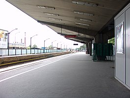
Örs vezér tere (früher: Fehér út) ist die östliche oberirdische Endstation der Linie M2 der Metró Budapest und wurde 1970 eröffnet.
Die Station befindet sich im XIV. Budapester Bezirk (Zugló).
Galerie
- Zugang
- (c) FOTO:FORTEPAN / Lovas Gábor, CC BY-SA 3.0Historisches Bild (1971)
Siehe auch
- Liste der Stationen der Metró Budapest
Weblinks
Auf dieser Seite verwendete Medien
(c) FOTO:FORTEPAN / Lovas Gábor, CC BY-SA 3.0
Örs vezér tere (Fehér út) metróvégállomás.
Official version from map pdfs on BKK website
Autor/Urheber: Babylonien86, Lizenz: CC BY-SA 3.0
Numerotation of the suburb of Budapest
Autor/Urheber:
Numerotation of the suburb of Budapest
Autor/Urheber:
M1 Metro (Budapest) logo
Autor/Urheber: Tomcsy, Lizenz: CC BY-SA 3.0
Line 2 (Budapest Metro), Örs vezér tere station at 2006
Numerotation of the suburb of Budapest
Transport in Budapest
Logo of Budapest Metro
Autor/Urheber:
M4 Metro logo (Budapest)
Numerotation of the suburb of Budapest
Autor/Urheber: Christo, Lizenz: CC BY-SA 4.0
Budapest, metró 2, Örs vezér tere
M2 Metro Logo (Budapest)


