Île Dumet

Île Dumet
GewässerBiskaya
Geographische Lage47° 24′ 39″ N, 2° 37′ 13″ W
Île Dumet (Loire-Atlantique)
Länge600 m
Breite150 m
Fläche8,5 ha
Einwohnerunbewohnt
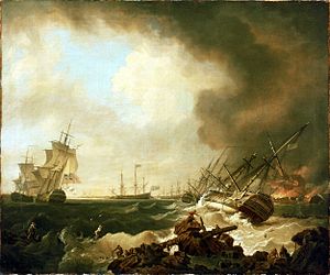
Künstlerische Darstellung der Schlacht von Quiberon vor der Île Dumet

Die Île Dumet ist eine kleine Insel vor der bretonischen Küste, die ein Naturschutzgebiet ist und zum Département Loire-Atlantique in der Region Pays de la Loire und zu der 6 km entfernten Gemeinde Piriac-sur-Mer gehört. Die Insel ist 8,5 ha groß, 600 m lang und 150 m breit.

Zum Namen

Früher hieß die Insel auch Aduna. Aus dem Namen wurde später Audumet, dann Dumay und dann der aktuelle Name. Auf Bretonisch heißt sie Enez Aodum.

Geschichte

Die Insel war früher bewohnt, gehörte zunächst dem Bistum Nantes und dann der Abtei Saint-Sauveur de Redon. Die Mönche tauschten die Insel mit dem Grafen Jacques de Mahé de la Bourdonnais, Sieur de La Bourdonnais (1674–1705), Schiffbauer und Kapitän und Vater des berühmten Admirals Bertrand François Mahé de La Bourdonnais. Die strategische Position führte später zu militärischer Besetzung zum Zwecke der Verteidigung der Mündung des Flusses Vilaine, die auch Schauplatz der Seeschlacht in der Bucht von Quiberon war.[1]

1912 platzierte Alphonse Berget den Pol der Landhemisphäre auf der Insel; spätere Berechnungen verschoben diesen Pol um einige Kilometer östlich nach Nantes.[2]

1949 erwarb Henri Dresch, Fabrikant der Motorräder Dresch, die Insel und ließ Bäume anpflanzen. 1953 bezog das Ehepaar Fleury de Valois das Wachhaus des Fort de Ré und lebte dort 33 Jahre ohne Elektrizität, mit wenig Süßwasser und nur einem Postboot alle 15 Tage, soweit das Wetter gut war. Das Paar nahm auch den Leuchtturm wieder in Betrieb.[3]

Henri Dresch verkaufte die Insel 1971 und 1990 ging sie in den Besitz der Küstenschutzbehörde (Conservatoire du littoral) über.[4]

Die Forts

Zwei Forts wurden auf der Insel gebaut.

Fort de Ré

Das Fort de Ré wurde halbrund um 1756 durch den Herzog von d’Aiguillon errichtet. Es diente bis zur Auflassung 1782 den Bewachern. Restauriert im 19. Jahrhundert wurde es später aufgegeben und um 1900 mit einem Leuchtfeuer zum Schutz der Schifffahrt umgenutzt.

Fort de Carré

Das Fort Carré, oder auch nach Sébastien Le Prestre de Vauban Fort Vauban genannt, wurde 1845 während der Anwesenheit von Gustave Flaubert gebaut.

Der Leuchtturm

Das Feuer ist in weiße, blaue und rote Sektoren geteilt. Der Leuchtturm leuchtet mit einer Frequenz von 12 Sekunden. Die Tragweite (Leuchtweite) beträgt 7 Meilen für weißes Licht und 4 Meilen für die farbigen Lichter.

Weblink

Piriac sur mer: Île Dumet. Abgerufen am 30. August 2022 (französisch).

Einzelnachweise

  1. Bulletin de la Société archéologique de Nantes et du département de la Loire-inférieure vom 1. Januar 1904. In: BnF Gallica. Abgerufen am 30. August 2022 (französisch).
  2. Alphonse berget: La répartition géographique des océans et la détermination du pôle continental. In: Annales de l'Institut océanographique. Abgerufen am 30. August 2022 (französisch).
  3. Jeanne roth: Les reclus de l'île Dumet werk=ina.fr. Abgerufen am 30. August 2022 (französisch).
  4. ILE DUMET. In: conservatoire-du-littoral. Abgerufen am 30. August 2022 (französisch).

Auf dieser Seite verwendete Medien

The Battle of Quiberon Bay, 21 November 1759- the Day After RMG BHC0402.tiff
The Battle of Quiberon Bay, 21 November 1759: the Day After

A painting showing the day after the Battle of Quiberon Bay. This was the most important and decisive naval encounter during the Seven Years War, 1756-63. It resulted in the destruction of the French Brest fleet and occurred when the French broke out of the five-month English blockade of Brest. The blockade was set up to prevent the French fleet sailing to collect troop transports assembled in the Gulf of Morbihan, in southern Brittany, for a planned invasion of Ireland. The battle stopped any plans the French had for invasion in the Seven Years War.

The two fleets met in the mouth of Quiberon Bay, 100 miles south-east of Brest. This is bounded to the north and north-west by the Quiberon peninsula and off-lying Belle-Ile, and to the south and south-west by the rocky coast at Le Croisic and the 'plateau du Four', a reef lying some two miles out to sea (now marked by a lighthouse). The English fleet was commanded by Admiral Sir Edward Hawke in the 'Royal George', 100 guns, and the French by Admiral Hubert Brienne de Conflans, Marshal of France, in the 'Soleil Royal', 80 guns. The battle was conducted amidst heavy squalls and deteriorating weather and when night fell some of the ships were among the rocks and shoals of the bay, without pilots or adequate charts. Two French ships of 74 and 70 guns, 'Thésée' and 'Superbe', sank in action, swamped by water flooding through open lower gunports, and when dawn came after a wild night the British 'Resolution' and 'Essex' were seen to be wrecked beyond help on the Four. The 'Soleil Royal' had been driven well into the bay close to anchored British ships and Conflans first ran her aground off Le Croisic and then burnt her to prevent capture. The 74-gun 'Héros', also deliberately grounded nearby after pursuit by the wrecked 'Essex', was taken by British boats and also burnt. Some French ships escaped south to Rochefort by weathering the Four, the 'Juste' being wrecked on the way off St Nazaire. Others took refuge deep in Quiberon Bay, in the Vilaine estuary, where the 64-gun 'Inflexible' was wrecked and from which the rest only escaped over several months in 1760-61.

The painting shows the French 'Soleil Royal' and 'Héros', in flames in the right distance, and the smoke from the fire rises and fans out across the top of the picture. In the right foreground the 'Resolution', 74 guns, lies wrecked in port-quarter view on the Four. She lies over on her starboard side, her mizzen mast gone and part of her mainmast missing, and she shows the creamy white 'paying stuff' or 'boot-topping' (a form of anti-fouling) on her underside. Ahead of her the 'Essex', 64 guns, is also aground in starboard-quarter view. Figures can still be seen on the deck. In the central background the 'Royal George', and other units of the English fleet are shown in port-broadside view at anchor in the strong wind. Some have blue ensigns, some red, and behind the 'Royal George' is what is probably the small islet of Dumet in Quiberon Bay. On the left of the picture are the captured French 'Formidable', 80 guns, in port-quarter view with an English two-decker on her port bow in starboard-quarter view. In the centre and right foreground are rocks with a mast thrown up on them. Shipwrecked sailors are shown clambering out of the surf and taking refuge there. One sailor sits on wreckage on the rocks in the foreground on the right. He has lost his shirt and his hair hangs bedraggled. In the left foreground a couple more sailors are still in the water clinging onto spars. On the right and on the left a man sits on the edge of the rocks holding a rope towards men in the water to help them to safety. The painting is highly stylized and includes other symbols of wreckage such as pieces of rope, cleats and a barrel. It also necessarily selects incidents and compresses the huge area across which they occurred into a single, evocative image. Around 1000 men - most of their crews - drowned from the English ships wrecked on the Four. Two makeshift rafts manned by a few and some French prisoners washed out to sea but some survivors from them were providentially rescued by two Dutch vessels; another, carrying about 30 English seamen, came ashore near Le Croisic.

Richard Wright was a self-taught artist who came from Liverpool. The painting was exhibited at the Society of Artists in 1763 and is signed and dated 'R Wright 1760' on the wreckage on the far left in the foreground.

The Battle of Quiberon Bay, 21 November 1759: the Day After
Loire-Atlantique department relief location map.jpg
Autor/Urheber: Eric Gaba (Sting - fr:Sting), Lizenz: CC BY-SA 3.0
Blank physical map of the department of Loire-Atlantique, France, for geo-location purpose, with distinct boundaries for regions, departments and arrondissements as in January 2018.