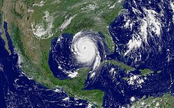
Dennis 2005-07-07 1550Z
A storm of this size is a threat not just because of its powerful winds: Dennis is expected to produce heavy rain and coastal and inland flooding. Five to ten inches of rain may fall over Haiti, the Dominican Republic, Jamaica, Cuba, and the Cayman Islands, with as much as 15 inches falling in parts of Jamaica. Heavy rainfall can trigger flash floods and mudslides in mountainous regions. The storm will probably also raise tide levels by five to seven feet and generate large and dangerous waves.
Dennis is expected to strengthen as it moves north towards the Gulf Coast of the United States. For official storm warnings and additional information, please visit the National Hurricane Center.
| Diese Datei ist gemeinfrei (public domain), da sie von der NASA erstellt worden ist. Die NASA-Urheberrechtsrichtlinie besagt, dass „NASA-Material nicht durch Urheberrecht geschützt ist, wenn es nicht anders angegeben ist“. (NASA-Urheberrechtsrichtlinie-Seite oder JPL Image Use Policy). |  | |
 |
Warnung:
|
Relevante Bilder
Relevante Artikel
HurrikanHurrikan wird ein tropischer Wirbelsturm im nördlichen atlantischen Ozean sowie im Nordpazifik östlich von 180° Länge und im Südpazifik östlich von 160° Ost genannt. Dieser muss mindestens Orkanstärke erreichen, also Windstärke 12 auf der Beaufortskala. Hurrikane entstehen in der Regel zwischen Mai und Dezember, die meisten davon zwischen Juli und September. Die offizielle Hurrikansaison dauert im Atlantischen Ozean und im zentralen Nordpazifik vom 1. Juni bis zum 30. November, im östlichen Nordpazifik beginnt sie bereits am 15. Mai. .. weiterlesen


