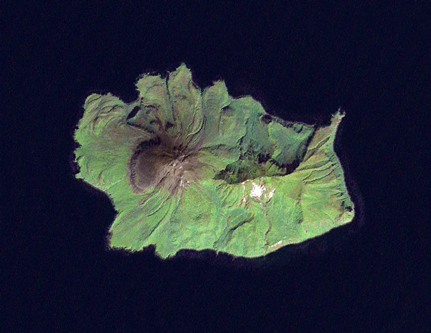
Ekarma - Landsat 7


Autor/Urheber:
Data: NASA. Image: Dave Pape
Größe:
880 x 680 Pixel (168195 Bytes)
Beschreibung:
Landsat 7 image of the Kuril Island of Ekarma, 14.25 meter resolution. Based on Global Orthorectified Landsat dataset (ETM+); WRS_PATH 101, WRS_ROW 026. Generated using panchromatic band for intensity, and color from "true-color" combination of 28.5 meter resolution bands 3, 2, & 1 (as R, G, B respectively). Data combined and color curves enhanced in the Gimp.
Kommentar zur Lizenz:
This work is based on a work in the public domain. It has been digitally enhanced and/or modified. This derivative work has been (or is hereby) released into the public domain by its author, Davepape. This applies worldwide.

In some countries this may not be legally possible; if so:

Davepape grants anyone the right to use this work for any purpose, without any conditions, unless such conditions are required by law.
Lizenz:
Public domain
Credit:
Data from USGS GloVis server http://glovis.usgs.gov/. Landsat Orthorectified data generated through NASA's Commercial Remote Sensing Program.
Bild teilen:
Facebook   Twitter   Pinterest   WhatsApp   Telegram   E-Mail
Weitere Informationen zur Lizenz des Bildes finden Sie hier. Letzte Aktualisierung: Thu, 10 Aug 2023 11:57:04 GMT

Relevante Bilder


Relevante Artikel

Ekarma

Ekarma ist eine Vulkaninsel der russischen Kurilen. Ekarma liegt zwischen Schiaschkotan und Tschirinkotan. Von der südöstlich gelegenen Insel Schiaschkotan ist sie durch die 8,5 Kilometer breite Ekarma-Straße getrennt. Rund 30 Kilometer westlich von Ekarma liegt Tschirinkotan. .. weiterlesen

Kurilen

Die Kurilen oder Kuril-rettō sind eine etwa 1200 Kilometer lange, zu Russland gehörige und territorial teilweise umstrittene Inselkette mit mehr als 30 großen und kleinen Inseln vulkanischen Ursprungs in Ostasien. Sie verbinden wie eine Kette die russische Halbinsel Kamtschatka mit der japanischen Insel Hokkaidō. Die Inselkette trennt das Ochotskische Meer vom offenen Rest des Pazifiks. .. weiterlesen