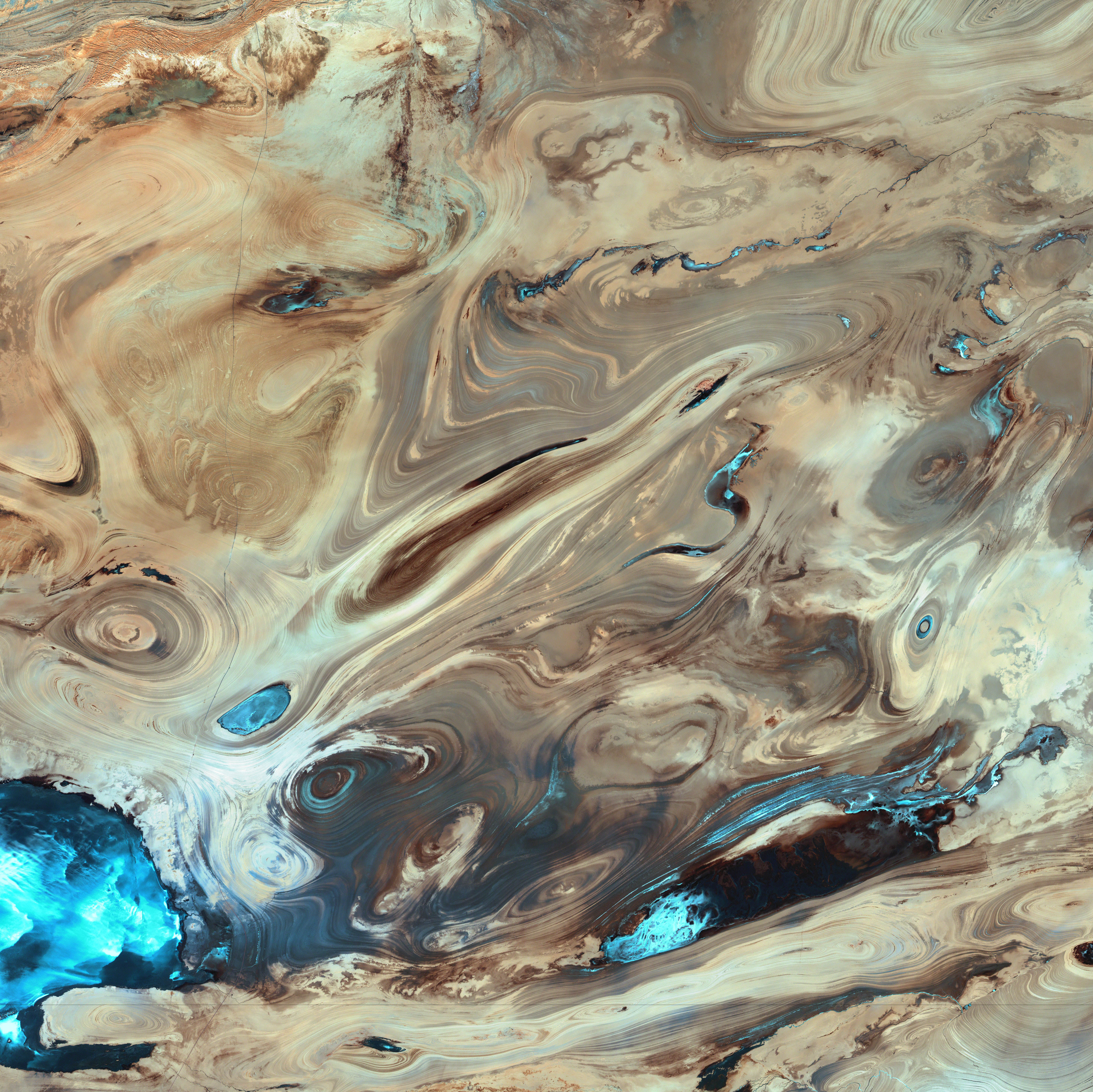
Dasht-e Kavir
The patterns you see are formed by different geological layers that have been eroded over thousands of years by wind and sometimes (but not often) rain.
The patterns are formed from either horizontal geological layers cut through by topographic changes, or geological formations (folds, domes, etc) in relatively flat terrain.
Most of the colours are due to chemical differences in the rocks, whilst the intense blue colours could be due to a range of materials, possibly salt deposits, possibly vegetation, depending on which area of the EM spectrum is represented by blue. I suspect (but don't know, the satellite bands to displayed colours are not mentioned) that the blue colours are salt deposits, but they could equally be other materials too. To be certain, knowledge of the bands to display colours is essential.
The black line running horizontally across the image is a sensor drop-out and the data for that line or lines has been irrevocably lost. The linear (but not straight) line running vertically down the middle left is a road.
USGS/NASA description: The Dasht-e Kevir, or Great Salt Desert, is the largest desert in Iran. It is primarily uninhabited wasteland, composed of mud and salt marshes covered with crusts of salt that protect the meager moisture from completely evaporating. This image was acquired by Landsat 7’s Enhanced Thematic Mapper plus (ETM+) sensor on October 24, 2000. This is a false-color composite image made using infrared, green, and red wavelengths. The image has also been sharpened using the sensor’s panchromatic band.


Relevante Bilder
_(Cropped).jpg)


.jpg)


.svg)


_1.jpg)


Relevante Artikel
Geographie IransDie Geographie Irans befasst sich mit der Oberfläche bzw. der Geographie von Iran. Iran liegt von Europa aus gesehen in Vorderasien im großen euro-asiatischen Hochgebirgsgürtel, der sich von der iberischen Halbinsel über Alpen, Karpaten, Balkan, Taurus und Pontus in den beiden iranischen Randgebirgen Alborz und Zagros fortsetzt und an die sich im Osten der zentralasiatische Hindukusch und das Karakorum anschließen sowie der ebenfalls zum alpidischen Gebirgsgürtel gehörende Himalaya. .. weiterlesen
IranIran ist ein Land in Vorderasien. Das Land wird im Norden vom Kaspischen Meer und im Süden durch den Persischen Golf begrenzt. Mit rund 90 Millionen Einwohnern und einer Fläche von etwa 1,65 Millionen Quadratkilometern zählt der Staat Iran zu den 20 bevölkerungsreichsten und größten Staaten der Erde. Hauptstadt, größte Stadt und wirtschaftliches und kulturelles Zentrum ist Teheran, weitere Städte mit mehr als 1,5 Millionen Einwohnern sind Maschhad, Isfahan, Karadsch, Schiras und Täbris. Im heutigen Staatsgebiet bestand in der frühen Antike mit dem Perserreich eine mächtige Zivilisation. .. weiterlesen