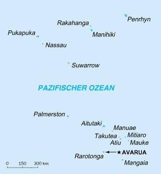
Cook Islands Map
Autor/Urheber:
CIA
Shortlink:
Quelle:
Größe:
330 x 355 Pixel (4648 Bytes)
Beschreibung:
Geographical map of the cook islands
Lizenz:
Public domain
Credit:
CIA world factbook
Bild teilen:


Relevante Bilder
.jpg)

_Aerial.jpg)
.svg)


.svg)


.svg)


.svg)
.JPG)


.svg)


Relevante Artikel
CookinselnDie Cookinseln sind ein unabhängiger Inselstaat in „freier Assoziierung mit Neuseeland“ und eine Inselgruppe im südlichen Pazifik. Ihre Fläche beträgt 236,7 km² und sie haben 14.987 Einwohner, die zum größten Teil den Cook Islands Māori zuzurechnen sind. Die Hauptstadt ist Avarua auf der Insel Rarotonga. .. weiterlesen