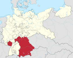
Bavaria locator map (1000)
Attribution:
Das Bild ist mit 'Attribution Required' markiert, aber es wurden keine Informationen über die Attribution bereitgestellt. Vermutlich wurde bei Verwendung des MediaWiki-Templates für die CC-BY Lizenzen der Parameter für die Attribution weggelassen. Autoren und Urheber finden für die korrekte Verwendung der Templates hier ein Beispiel.
Shortlink:
Quelle:
Größe:
4431 x 3875 Pixel (4932454 Bytes)
Beschreibung:
A map of the Duchy of Bavaria (German: Herzogtum Bayern) around the year 1000.
The map is derived from a vectorised version of one found in Professor G. Droysens Allgemeiner Historischer Handatlas, which was published in 1886 by R. Andrée Plate, and is now in the public domain.
Note that while it uses the same scheme as standard location/locator maps, this map technically does not conform to the standard, as it is not in equirectangular projection. Therefore grid lines for latitude and longitude are also included.
Lizenz:
Credit:
File: own work
Data: File:Droysens-22-23.jpg
Data: File:Droysens-22-23.jpg
Relevante Bilder
Relevante Artikel
Geschichte BayernsDie Geschichte Bayerns umfasst die Entwicklungen auf dem Gebiet des deutschen Bundeslandes Freistaat Bayern und historischer bayrischer Reiche von der Urgeschichte bis zur Gegenwart. .. weiterlesen


