Rio Grande del Norte National Monument


Das Rio Grande del Norte National Monument ist ein US-amerikanisches National Monument im Rio Grande Gorge mit Rio Grande im Taos County im Norden von New Mexico. Die Nordgrenze des Schutzgebietes ist gleichzeitig aus die Grenze zu Colorado. Es wurde durch Präsident Barack Obama durch eine Presidential Proclamation am 25. März 2013 mit einer Flächengröße von 242.555 Acres (98.159 ha) ausgewiesen. Das National Monument wurde wegen des Vorhandenseins gefährdeter Tier- und Pflanzenarten und wichtiger historischer Fundstellen ausgewiesen.[1]
Verwaltung und Flächenbesitz des National Monuments
Das Rio Grande del Norte National Monument steht unter der Verwaltung des Bureau of Land Management (BLM). Die gesamten Flächen befinden sich im Bundesbesitz und wurde bereits vor der Ausweisung vom BLM betreut.[1]
Privatgrundstücke innerhalb der Grenzen des National Monumentes sind nicht Teil des Schutzgebietes. Diese Privatgrundstücke können nur Teil des National Monuments werden, sofern sie freiwillig von den Vereinigten Staaten erworben werden können. Erwirbt der Bund Privatgrundstücke innerhalb des National Monument, so werden diese Grundstücke Teil des Schutzgebietes. Die Ausweisung des National Monuments hat keinen Einfluss auf die Rechte von Eigentümern von Grundstücken, welche sich nicht im Eigentum der USA befinden im oder an den Grenzen des Schutzgebietes.[1]
Die Schutzausweisung berührt nicht bestehende Bewilligungen für die Beweidung mit Vieh innerhalb des Gebietes und diese darf weiterhin fortgeführt werden. Auch die Nutzung von Wasserrechten im Schutzgebiet wird im Schutzgebiet nicht eingeschränkt.[1]
Im Schutzgebiet ist Wandern, Angeln, Rafting, Jagen, Camping, Vogelbeobachten, Klettern, Mountainbiken, Reiten und weitere Freizeitnutzungen erlaubt.[1]
Außer für Notfall- oder genehmigte Verwaltungszwecke ist die Benutzung von Kraftfahrzeugen im Schutzgebiet nur auf ausgewiesenen Straßen und Wegen gestattet.[1]
Durch das National Monument führen zahlreiche Straßen darunter Highways. Dazu gehört der U.S. Highway 285. Der U.S. Highway 64 überquert den Fluss über die 200 m hohe Rio Grande Gorge Bridge. Auch der State Highway New Mexico Highway 570 und der Wild Rivers Backcountry Byway verlaufen im Gebiet.
Tier- und Pflanzenarten
Zahlreichen Vogel-, Säugetier-, Eidechsen-, Fledermaus-, Insekten- und Schlangenarten sind im Gebiet zu finden. Unter den Säugetierarten im Gebiet befinden sich Dickhornschaf, Gabelbock, Maultierhirsch, Wapiti, Gunnisons Präriehund, Rotfuchs, Kojote, Nordamerikanisches Katzenfrett, Rotluchs, Puma und Schwarzbär. Der bereits ausgerottete Nordamerikanischer Fischotter wurde widerangesiedelt. Das Schutzgebiet bietet einen wichtigen Wanderkorridor für Tierarten zwischen den beiden dortigen Gebirgszügen.[1]
Der Río Grande del Norte ist Teil des Central Migratory Flyway, einem wichtigen Zugvogelkorridor für Vögel wie Kanadagans, Kanadakranich, Reiherarten, Kolibris und Amerikanischer Säbelschnäbler. Das Gebiet ist ein wichtiges Überwinterungsgebiet für Vögel. Ganzjährig leben hier Vogelarten wie Truthuhn, Schuppenwachtel, Carolinataube, Bergregenpfeifer und Louisianawürger. Auch der bedrohte Willow flycatcher (Empidonax traillii) lebt hier. Es kommen zahlreiche Greifvogelarten wie Truthahngeier, Weißkopfseeadler und Steinadler vor.[1]
Neben felsigen Bereichen gibt es große Bereiche mit Salbeisteppe und Grasland. In Hochlagen wächst auch Wald. Es kommt an Felsbereichen der Schucht die Kakteenart Echinocereus triglochidiatus vor.[1]
Menschen im Gebiet
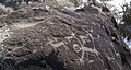
Die Indianer Amerikas bewohnen dieses Gebiet seit mindestens 7.500 Jahren. In die Felsen und Klippen sind hunderte von Petroglyphen eingemeißelt, die von scheinbar abstrakten Wirbeln und Punkten bis hin zu klaren Darstellungen von Menschen und Tieren reichen. Dichte Ansammlungen von Petroglyphen befinden sich in der Nähe der heißen Quellen, die im tiefen Herzen der Schlucht sprudeln, von denen einige auf die archaische Zeit zurückgehen. Viele archäologische Fundstellen wurden entdeckt. Dies reicht von Resten von Grubenhäusern, Topfscherben, Werkzeugen und Geschossspitzen bis zu großen Keramikgefäßen. Es wurden Spuren der Indianerstämme Jicarilla Apachen und Ute Stämmen gefunden. Auch die Indianer des Taos Pueblo und der Picuris Pueblos nutzten das Gebiet. Neuere Artefakte und Bilder kennzeichnen den Weg der Siedler und hispanischen Entdecker ab dem frühen 18. Jahrhundert. Auch verlassene Ranches aus den 1930er Jahren sind zu finden.[1]
Es gibt im Rio Grande del Norte National Monument zwei BLM Visitor Center. Das Wild Rivers Visitor Center liegt im Wild Rivers Recreation Area nahe Questa. Das Rio Grande Gorge Visitor Center liegt im Orilla Verde Recreation Area nahe Pilar.
Bildergalerie

Eingang zum Nationalmonument

Ute Mountain mit blühenden Blumen

Dickhornschaf

Rafting
Weblinks
Einzelnachweise
Admiralty Island | African Burial Ground | Agate Fossil Beds | Agua Fria | Aleutian Islands World War II | Alibates Flint Quarries | Aniakchak | Aztec Ruins | Bandelier | Basin and Range | Bears Ears | Belmont-Paul Women’s Equality | Berryessa Snow Mountain | Birmingham Civil Rights | Booker T. Washington | Browns Canyon | Buck Island Reef | Cabrillo | California Coastal | Camp Hale - Continental Divide | Camp Nelson Heritage | Canyon De Chelly | Canyons of the Ancients | Cape Krusenstern | Capulin Volcano | Carrizo Plain | Casa Grande Ruins | Cascade-Siskiyou | Castillo de San Marcos | Castle Clinton | Castle Mountains | Cedar Breaks | César E. Chávez | Charles Young Buffalo Soldiers | Chimney Rock | Chiricahua | Colorado | Craters of the Moon | Devils Postpile | Devils Tower | Dinosaur | Effigy Mounds | El Malpais | El Morro | Florissant Fossil Beds | Fort Frederica | Fort Matanzas | Fort McHenry | Fort Monroe | Fort Ord | Fort Pulaski | Fort Stanwix | Fort Union | Fossil Butte | Freedom Riders | George Washington Birthplace | George Washington Carver | Giant Sequoia | Gila Cliff Dwellings | Gold Butte | Governors Island | Grand Canyon-Parashant | Grand Portage | Grand Staircase-Escalante | Hagerman Fossil Beds | Hanford Reach | Harriet Tubman Underground Railroad | Hohokam Pima | Hovenweep | Ironwood Forest | Jewel Cave | John Day Fossil Beds | Jurassic | Kasha-Katuwe Tent Rocks | Katahdin Woods and Waters | Lava Beds | Little Bighorn Battlefield | Marianas Trench | Medgar and Myrlie Evers Home | Military Working Dog Teams | Mill Springs Battlefield | Misty Fjords | Mojave Trails | Montezuma Castle | Mount St. Helens | Muir Woods | Natural Bridges | Navajo | Newberry | Northeast Canyons and Seamounts | Oregon Caves | Organ Mountains-Desert Peaks | Organ Pipe Cactus | Pacific Remote Islands | Papahānaumokuākea | Petroglyph | Pipe Spring | Pipestone | Pompeys Pillar | Poverty Point | Prehistoric Trackways | President Lincoln and Soldiers’ Home | Rainbow Bridge | Río Grande del Norte | Rose Atoll | Russell Cave | Saint Francis Dam Disaster | Salinas Pueblo Missions | San Gabriel Mountains | San Juan Islands | Sand to Snow | Santa Rosa and San Jacinto Mountains | Scotts Bluff | Sonoran Desert | Statue of Liberty | Stonewall | Sunset Crater | Timpanogos Cave | Tonto | Tule Lake | Tule Springs Fossil Beds | Tuzigoot | Upper Missouri River Breaks | Vermilion Cliffs | Virgin Islands Coral Reef | Waco Mammoth | Walnut Canyon | Wupatki | Yucca House
Koordinaten: 36° 39′ 36″ N, 105° 42′ 0″ W
Auf dieser Seite verwendete Medien
.jpg)
Go for a hike and listen for an eagle as it soars above an 800-foot gorge, fish in world-class trout waters, marvel at a herd of elk crossing the desolate plateau, or raft alongside the river otter. You have entered the natural world of the Río Grande del Norte National Monument!
The landscape of this special place in northern New Mexico is a showcase of stark, wide open spaces covering 242,500 acres. At an average elevation of 7,000 feet, the monument is dotted by volcanic cones and cut by steep canyons. While the Río Grande carves a deep gorge through layers of volcanic basalt flows and ash, nearby cottonwoods and willows shelter abundant songbirds and waterfowl. An amazing array of wildlife dwells among the piñon and juniper woodlands and the mountaintops of ponderosa, Douglas fir, aspen, and spruce (some 500 years old). Raptors, mule deer, cougar, and black bear are not uncommon. Be alert! At any moment bighorn sheep may appear!
Since prehistoric times this area has attracted human activity, as evidenced by petroglyphs, prehistoric dwelling sites, and many other types of archaeological discoveries. Abandoned homesteads from the 1930s reflect more recent activity. On March 25, 2013, a Presidential proclamation designated the area a national monument, managed by the Bureau of Land Management as part of the National Landscape Conservation System.
Learn more about the monument: www.blm.gov/nm/riograndedelnorte
Photos by Bob Wick, BLMMap of Rio Grande del Norte National Monument, New Mexico, USA
.jpg)
The Río Grande Wild and Scenic River, located within the Río Grande del Norte National Monument, includes 74 miles of the river as it passes through the 800-foot deep Río Grande Gorge. Flowing out of the snowcapped Rocky Mountains in Colorado, the river journeys 1,900 miles to the Gulf of Mexico. Here the river flows in a rugged and scenic part of northern New Mexico. The river was made a part of the National Wild and Scenic River System in 1968; among the first eight rivers Congress designated as Wild and Scenic. The river gorge is home to numerous species of wildlife, including big horn sheep, river otter, and the Río Grande cutthroat trout.
The Río Grande Wild and Scenic River provides a wide variety of recreational opportunities, luring anglers, hikers, artists, and whitewater boating enthusiasts. Two developed recreation areas are located along the river: Wild Rivers on the north and Orilla Verde in the south. In addition to these scenic recreation areas, a spectacular vista of the gorge is seen from the High Bridge Overlook where highway 64 crosses.
Learn more about the area and plan your trip: www.blm.gov/nm/st/en/prog/recreation/taos/rio_grande_wsr....
Photo: Bob Wick, BLM California.jpg)
Go for a hike and listen for an eagle as it soars above an 800-foot gorge, fish in world-class trout waters, marvel at a herd of elk crossing the desolate plateau, or raft alongside the river otter. You have entered the natural world of the Río Grande del Norte National Monument!
The landscape of this special place in northern New Mexico is a showcase of stark, wide open spaces covering 242,500 acres. At an average elevation of 7,000 feet, the monument is dotted by volcanic cones and cut by steep canyons. While the Río Grande carves a deep gorge through layers of volcanic basalt flows and ash, nearby cottonwoods and willows shelter abundant songbirds and waterfowl. An amazing array of wildlife dwells among the piñon and juniper woodlands and the mountaintops of ponderosa, Douglas fir, aspen, and spruce (some 500 years old). Raptors, mule deer, cougar, and black bear are not uncommon. Be alert! At any moment bighorn sheep may appear!
Since prehistoric times this area has attracted human activity, as evidenced by petroglyphs, prehistoric dwelling sites, and many other types of archaeological discoveries. Abandoned homesteads from the 1930s reflect more recent activity. On March 25, 2013, a Presidential proclamation designated the area a national monument, managed by the Bureau of Land Management as part of the National Landscape Conservation System.
Learn more about the monument: www.blm.gov/nm/riograndedelnorte
Photos by Bob Wick, BLM
.jpg)
Go for a hike and listen for an eagle as it soars above an 800-foot gorge, fish in world-class trout waters, marvel at a herd of elk crossing the desolate plateau, or raft alongside the river otter. You have entered the natural world of the Río Grande del Norte National Monument!
The landscape of this special place in northern New Mexico is a showcase of stark, wide open spaces covering 242,500 acres. At an average elevation of 7,000 feet, the monument is dotted by volcanic cones and cut by steep canyons. While the Río Grande carves a deep gorge through layers of volcanic basalt flows and ash, nearby cottonwoods and willows shelter abundant songbirds and waterfowl. An amazing array of wildlife dwells among the piñon and juniper woodlands and the mountaintops of ponderosa, Douglas fir, aspen, and spruce (some 500 years old). Raptors, mule deer, cougar, and black bear are not uncommon. Be alert! At any moment bighorn sheep may appear!
Since prehistoric times this area has attracted human activity, as evidenced by petroglyphs, prehistoric dwelling sites, and many other types of archaeological discoveries. Abandoned homesteads from the 1930s reflect more recent activity. On March 25, 2013, a Presidential proclamation designated the area a national monument, managed by the Bureau of Land Management as part of the National Landscape Conservation System.
Learn more about the monument: www.blm.gov/nm/riograndedelnorte
Photos by Bob Wick, BLMUte Mountain (10, 093 ft) and the upper Rio Grande gorge
