Plaines Wilhems
Koordinaten: 20° 18′ S, 57° 29′ O
| Distrikt Plaines Wilhems | |
|---|---|
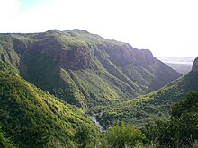
 Tamarind-Wasserfall | |
| Basisdaten | |
| Bezirkshauptstadt: | Beau Bassin-Rose Hill |
| Fläche: | 203.3 km² |
| Einwohner: | 368621 (2015)[1] |
| Bevölkerungsdichte: | 1800 Ew./km² |
| ISO 3166-2: | MU-PW |
| Zeitzone: | UTC+4 |
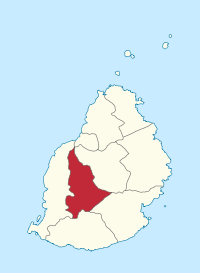
| Lage in Mauritius | |
Plaines Wilhems ist ein Bezirk auf dem Inselstaat Mauritius und liegt im Zentrum der Insel. Es ist neben Moka der einzige Bezirk ohne Meerzugang. Seine Bezirkshauptstadt ist Beau Bassin-Rose Hill. Vier der größten fünf Städte von Mauritius liegen in Plaines Wilhems.
Gemeinden
Mauritius ist zu Verwaltungszwecken in Gemeinden („Village Council Areas“) (VCA) eingeteilt. Die folgende Tabelle nennt die VCA die (zumindest teilweise) im Distrikt Plaines Wilhems liegen. Die Grenzen der Distrikte sind nicht deckungsgleich mit denen der Gemeinden. Gemeinden sind daher teilweise zwei oder drei Distrikten zugeordnet. Im Distrikt Plaines Wilhems liegen drei Gemeinden (VCA) und 14 Stadtteile (Ward).[2]
| Nr. | Ortsname | Abgrenzung |
|---|---|---|
| 1703 | Midlands VCA | |
| 1704 | Moka VCA (West) | Ost im Distrikt Moka |
| 1705 | Cascavelle VCA (Ost) | West im Distrikt Black River |
| 1711 | Beau Bassin-Rose Hill (Ward 1) | |
| 1712 | Beau Bassin-Rose Hill (Ward 2) | |
| 1713 | Beau Bassin-Rose Hill (Ward 3) | |
| 1714 | Beau Bassin-Rose Hill (Ward 4) | |
| 1721 | Quatre Bornes (Ward 1) | |
| 1722 | Quatre Bornes (Ward 2) | |
| 1723 | Quatre Bornes (Ward 3, Ost) | West im Distrikt Black River |
| 1731 | Vacoas-Phoenix (Ward 1) | |
| 1732 | Vacoas-Phoenix (Ward 2) | |
| 1733 | Vacoas-Phoenix (Ward 3) | |
| 1734 | Vacoas-Phoenix (Ward 4, West) | Ost im Distrikt Moka |
| 1741 | Curepipe (Ward 1) | |
| 1742 | Curepipe (Ward 2, West) | Ost im Distrikt Moka |
| 1743 | Curepipe (Ward 3) |
Einzelnachweise
- ↑ Ministry of Finance & Economic Development: ANNUAL DIGEST OF STATISTICS 2015 (PDF; 6,18 MB) Government of Mauritius. S. 19. August 2016. Abgerufen am 23. Dezember 2016.
- ↑ Statistics Mauritius: Housing and population census 2011, Volume II: Demographic and fertility characteristics, S. 137-141, statsmauritius.govmu.org (PDF)
Weblinks
Auf dieser Seite verwendete Medien
Autor/Urheber: Yashveer Poonit, Lizenz: CC BY-SA 3.0
The armorial ensigns and supporters of Mauritius are described as:
(a) for arms-
- Quarterly azure and or.
- In the first quarter a lymphad or.
- In the second, 3 palm trees vert.
- In the third, a key in pale the wards downwards gules.
- In the issuant, from the base a pile, and in chief a mullet argent.
(b) for the supporters-
- On the dexter side, a dodo per bend sinister embattled gules and argent, and
- On the sinister side, a sambur deer per bend embattled argent and gules, each supporting a sugar cane erect proper,
Autor/Urheber: TUBS
Lage des Distrikts XY (siehe Dateiname) in Mauritius.


