Peoria County
 Peoria County Courthouse | |
| Verwaltung | |
|---|---|
| US-Bundesstaat: | Illinois |
| Verwaltungssitz: | Peoria |
| Adresse des Verwaltungssitzes: | Peoria County Courthouse 324 Main Street Peoria, Illinois 61602 |
| Gründung: | 13. Januar 1825 |
| Gebildet aus: | Sangamon County |
| Vorwahl: | 001 309 |
| Demographie | |
| Einwohner: | 181.830 (Stand: 2020) |
| Bevölkerungsdichte: | 113,29 Einwohner/km2 |
| Geographie | |
| Fläche gesamt: | 1634 km² |
| Wasserfläche: | 29 km² |
| Karte | |
 | |
| Website: www.co.peoria.il.us | |
Das Peoria County[1] ist ein County im US-amerikanischen Bundesstaat Illinois. Im Jahr 2010 hatte das County 186.494 Einwohner und eine Bevölkerungsdichte von 116,2 Einwohnern pro Quadratkilometer.[2] Der Verwaltungssitz (County Seat) ist Peoria.[3]
Geografie
Das County liegt im mittleren Nordwesten von Illinois am rechten Ufer des Illinois River, der sich vor der Stadt Peoria zum Peoria Lake ausweitet.
Das County hat eine Fläche von 1634 Quadratkilometern, wovon 29 Quadratkilometer Wasserfläche sind.
An das Peoria County grenzen folgende Nachbarcountys:
| Knox County | Stark County | Marshall County |
.svg) | Woodford County | |
| Fulton County | Tazewell County |
Schutzgebiete

- Jubilee College State Park
- Wildlife Prairie State Park
Geschichte
| Bevölkerungsentwicklung | |||
|---|---|---|---|
| Census | Einwohner | ± rel. | |
| 1840 | 6.153 | — | |
| 1850 | 17.547 | 185,2 % | |
| 1860 | 36.601 | 108,6 % | |
| 1870 | 47.540 | 29,9 % | |
| 1880 | 55.355 | 16,4 % | |
| 1890 | 70.378 | 27,1 % | |
| 1900 | 88.608 | 25,9 % | |
| 1910 | 100.255 | 13,1 % | |
| 1920 | 111.710 | 11,4 % | |
| 1930 | 141.344 | 26,5 % | |
| 1940 | 153.374 | 8,5 % | |
| 1950 | 174.347 | 13,7 % | |
| 1960 | 189.044 | 8,4 % | |
| 1970 | 195.318 | 3,3 % | |
| 1980 | 200.466 | 2,6 % | |
| 1990 | 182.827 | −8,8 % | |
| 2000 | 183.433 | 0,3 % | |
| 2010 | 186.494 | 1,7 % | |
| 2020 | 181.830 | −2,5 % | |
| Vor 1900[4] 1900–1990[5] 2000[3] 2010[2] | |||
Das Peoria County wurde am 13. Januar 1825 aus Teilen des Sangamon County gebildet. Benannt wurde es nach den Peoria, einem Indianerstamm der Illinois-Konföderation.
Territoriale Entwicklung
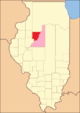
Das Peoria County von seiner Gründung im Jahr 1825 bis 1826

1826 bis 1827
1827 bis 1830

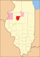
1830 bis 1831

1831 bis heute
Demografische Daten
Nach der Volkszählung im Jahr 2010 lebten im Peoria County 186.494 Menschen in 75.416 Haushalten. Die Bevölkerungsdichte betrug 116,2 Einwohner pro Quadratkilometer. In den 75.416 Haushalten lebten statistisch je 2,38 Personen.
Ethnisch betrachtet setzte sich die Bevölkerung zusammen aus 75,7 Prozent Weißen, 17,9 Prozent Afroamerikanern, 0,4 Prozent amerikanischen Ureinwohnern, 3,3 Prozent Asiaten sowie aus anderen ethnischen Gruppen; 2,6 Prozent stammten von zwei oder mehr Ethnien ab. Unabhängig von der ethnischen Zugehörigkeit waren 4,0 Prozent der Bevölkerung spanischer oder lateinamerikanischer Abstammung.
24,1 Prozent der Bevölkerung waren unter 18 Jahre alt, 61,9 Prozent waren zwischen 18 und 64 und 14,0 Prozent waren 65 Jahre oder älter. 51,5 Prozent der Bevölkerung war weiblich.
Das jährliche Durchschnittseinkommen eines Haushalts lag bei 50.689 USD. Das Pro-Kopf-Einkommen betrug 28.743 USD. 15,4 Prozent der Einwohner lebten unterhalb der Armutsgrenze.[2]
Ortschaften im Peoria County
|
|
|
|
Census-designated places (CDP)
- Rome
- Lake Camelot
|
|
|
|
|
1 – überwiegend im Tazewell County
Gliederung
Das Peoria County ist in 20 Townships eingeteilt[6]:
|
|
Siehe auch
Einzelnachweise
- ↑ GNIS-ID: 1784920. Abgerufen am 22. Februar 2011 (englisch).
- ↑ a b c U.S. Census Buero, State & County QuickFacts - Peoria County, IL (Seite nicht mehr abrufbar, festgestellt im Mai 2023. Suche in Webarchiven.) Archivierte Webseiten von WebCite sind nicht mehr abrufbar (siehe Disk) Info: Der Archivlink wurde automatisch eingesetzt und noch nicht geprüft. Bitte prüfe Original- und Archivlink gemäß Anleitung und entferne dann diesen Hinweis. Abgerufen am 26. Dezember 2012
- ↑ a b National Association of Counties Abgerufen am 26. Dezember 2012
- ↑ U.S. Census Bureau - Census of Population and Housing Abgerufen am 15. März 2011
- ↑ Auszug aus Census.gov Abgerufen am 15. Februar 2011
- ↑ Missouri Census Data Center - Illinois (Seite nicht mehr abrufbar, festgestellt im Mai 2019. Suche in Webarchiven.) Info: Der Link wurde automatisch als defekt markiert. Bitte prüfe den Link gemäß Anleitung und entferne dann diesen Hinweis. Abgerufen am 26. Dezember 2012
Weblinks
Liste der Countys in Illinois
Adams | Alexander | Bond | Boone | Brown | Bureau | Calhoun | Carroll | Cass | Champaign | Christian | Clark | Clay | Clinton | Coles | Cook | Crawford | Cumberland | DeKalb | DeWitt | Douglas | DuPage | Edgar | Edwards | Effingham | Fayette | Ford | Franklin | Fulton | Gallatin | Greene | Grundy | Hamilton | Hancock | Hardin | Henderson | Henry | Iroquois | Jackson | Jasper | Jefferson | Jersey | Jo Daviess | Johnson | Kane | Kankakee | Kendall | Knox | LaSalle | Lake | Lawrence | Lee | Livingston | Logan | Macon | Macoupin | Madison | Marion | Marshall | Mason | Massac | McDonough | McHenry | McLean | Menard | Mercer | Monroe | Montgomery | Morgan | Moultrie | Ogle | Peoria | Perry | Piatt | Pike | Pope | Pulaski | Putnam | Randolph | Richland | Rock Island | Saline | Sangamon | Schuyler | Scott | Shelby | St. Clair | Stark | Stephenson | Tazewell | Union | Vermilion | Wabash | Warren | Washington | Wayne | White | Whiteside | Will | Williamson | Winnebago | Woodford
Koordinaten: 40° 47′ N, 89° 46′ W
Auf dieser Seite verwendete Medien

Locator Map of Peoria County, Illinois, 1827-1831.
Based on: Illinois Secretary of State. Origin and Evolution of Illinois Counties. March 2010. p. 50. http://www.cyberdriveillinois.com/publications/pdf_publications/ipub15.pdf

Locator Map of Peoria County, Illinois, 1831.
Based on: Illinois Secretary of State. Origin and Evolution of Illinois Counties. March 2010. p. 51. http://www.cyberdriveillinois.com/publications/pdf_publications/ipub15.pdf
Locator Map of Peoria County, Illinois, 1826-1827.
Based on: Illinois Secretary of State. Origin and Evolution of Illinois Counties. March 2010. p. 48. http://www.cyberdriveillinois.com/publications/pdf_publications/ipub15.pdf(c) ThreeOneFive in der Wikipedia auf Englisch, CC BY 3.0
Federal Building and U.S. Courthouse, 100 NE Monroe St. (east corner with Main St.), Peoria, Illinois. This building is mainly courts of the United States District Court for the Central District of Illinois, and was also the United States Post Office for Peoria before the State Street post office was opened. Right background: Associated Bank building

Locator Map of Peoria County, Illinois, 1830-1831.
Based on: Illinois Secretary of State. Origin and Evolution of Illinois Counties. March 2010. p. 50-52. http://www.cyberdriveillinois.com/publications/pdf_publications/ipub15.pdfAutor/Urheber: aka Kath, Lizenz: CC BY 2.0
I noticed that the car I was riding on was built in Wisconsin Dells, WI. I rode on a narrow gauge railroad when I was there a couple of years ago. I need to see if it's the same place that built both train collections.
This is a locator map showing Peoria County in Illinois. For more information, see Commons:United States county locator maps.

Locator Map of Peoria County, Illinois, 1825-1826.
Based on: Illinois Secretary of State. Origin and Evolution of Illinois Counties. March 2010. p. 46. http://www.cyberdriveillinois.com/publications/pdf_publications/ipub15.pdf