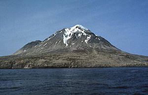
Kagamil Island
| Kagamil Island | ||
|---|---|---|
 Kagamil | ||
| Höhe | 893 m | |
| Lage | Aleuten (Alaska) | |
| Koordinaten | 52° 58′ 26″ N, 169° 43′ 4″ W | |
| Typ | Schichtvulkan | |
| Letzte Eruption | Dezember 1929 | |
Kagamil Island (aleutisch: Qagaamila) ist eine der Islands of Four Mountains, einer Inselgruppe der Aleuten in Alaska. Sie liegt 6 km nördlich von Chuginadak Island und ist 2 km südlich von Uliaga Island entfernt. Sie ist 10 km lang und 5 km breit. Die Insel ist schwer zu erreichen.
Der Vulkan
Die südliche Hälfte der Insel wird durch den Kagamil-Vulkan bestimmt. Es handelt sich dabei um einen Schichtvulkan. Dieser hat zwei Gipfel, der höhere liegt 893 m über dem Meeresspiegel, der niedrigere ist 690 m hoch. Von der vulkanischen Aktivität zeugen auch heiße Quellen und Fumarolen an der Süd-Ost-Seite der Insel. Der letzte (bekannte) Ausbruch erfolgte im Dezember 1929.
Weblinks
- Kagamil Island im Global Volcanism Program der Smithsonian Institution (englisch)
- Alaska Vulcano Observatory(engl.)
- National Geographic 1999/2000 (engl.)
- Bild und Kurzbeschreibung (engl.) (Memento vom 23. Dezember 2010 im Internet Archive)
- Canadian Mountain Encyclopedia (engl.)
Auf dieser Seite verwendete Medien
The southern half of 5 x 10 km Kagamil Island in the NE part of the "Islands of Four Mountains" group contains two undissected cones of postglacial age with small summit craters. The larger, 893-m-high cone (center) is seen here from the SW and is located at the SE end of the NNW-SSE-trending volcano. Hot springs and fumaroles occur near the SE coast. The early explorer Veniaminof indicated that Kagamil, also known as Kigamiljach, formerly "flamed and smoked," but the only eruptive report is of unspecified activity in 1929.


