Interstate 980
| Basisdaten | |
|---|---|
| Länge: | 2,02 mi/3,25 km |
| Bundesstaat: | Kalifornien |
| Karte | |
 | |
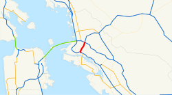
Die Interstate 980 (kurz I-980) ist ein Interstate Highway im US-Bundesstaat Kalifornien. Sie verbindet Interstate 580 und Interstate 880 und verläuft über die gesamte Länge in der Stadt Oakland im Alameda County. An der Kreuzung mit der Interstate 580 besteht gleichzeitig ein Übergang zur California State Route 24. I-980 trägt den Beinamen Grove Shafter Freeway.
Geschichte
Die Strecke der heutigen Interstate 980 wurde 1947 unter der Bezeichnung Legislative Route 226 im State Highway System von Kalifornien aufgenommen. Bei der Neuvergabe der Nummern 1964 wurde die Straße Teil der California State Route 24. Im Jahr 1976 wurde ein 0,8 Meilen langer Abschnitt westlich der San Pablo Avenue von der Federal Highway Administration zur Interstate hochgestuft. Bis 1985 folgten auch die restlichen 1,1 Meilen bis zur I-580.
Weblinks
- Interstate-Guide (englisch)
Auf dieser Seite verwendete Medien
25 in by 30 in (635 mm by 762 mm) Interstate shield, made to the specifications of the 1971 Caltrans sign drawing (still in use). Uses the Roadgeek 2005 fonts. (United States law does not permit the copyrighting of typeface designs, and the fonts are meant to be copies of a U.S. Government-produced work anyway.) Colors are from [1] (Pantone Red 187 and Blue 294), converted to RGB by [2]. The outside border has a width of 1 and a color of black so it shows up; in reality, signs have no outside border.
This is a map of Interstate 980 in California.
Vector image of a 24 in by 25 in (600 mm by 635 mm) California State Route shield. Colors are from [1] (Pantone Green 342), converted to RGB by [2]. The outside border has a width of 1 (1/16 in) and a color of black so it shows up; in reality, signs have no outside border.


