Interstate 79
| Basisdaten | ||||||||||||||||||||||
|---|---|---|---|---|---|---|---|---|---|---|---|---|---|---|---|---|---|---|---|---|---|---|
| Länge: | 343 mi/552 km | |||||||||||||||||||||
| Bundesstaaten: | West Virginia Pennsylvania | |||||||||||||||||||||
| Karte | ||||||||||||||||||||||
 | ||||||||||||||||||||||
Verlauf
| ||||||||||||||||||||||
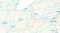
Die Interstate 79 (kurz I-79) ist ein Interstate Highway in den Vereinigten Staaten. Sie beginnt an der Interstate 77 in Charleston und endet an den Pennsylvania State Routes 5 und 290 in Erie.
Längen
| Meilen | km | Staat | |
| 160 | 258 | West Virginia | |
| 182 | 294 | Pennsylvania | |
| 343 | 552 | Total | |
Wichtige Städte
- Charleston (West Virginia)
- Clarksburg (West Virginia)
- Fairmont (West Virginia)
- Morgantown (West Virginia)
- Washington (Pennsylvania)
- Canonsburg (Pennsylvania)
- Crafton (Pennsylvania)
- Wexford (Pennsylvania)
- Grove City (Pennsylvania)
- Erie (Pennsylvania)
Zubringer und Umgehungen
- Interstate 279 und Interstate 579 bei Pittsburgh
Weblinks
Auf dieser Seite verwendete Medien
600 mm by 600 mm (24 in by 24 in) Interstate shield, made to the specifications of the 2004 edition of Standard Highway Signs (sign M1-1). Uses the Roadgeek 2005 fonts. (United States law does not permit the copyrighting of typeface designs, and the fonts are meant to be copies of a U.S. Government-produced work anyway.) Colors are from [1] (Pantone Red 187 and Blue 294), converted to RGB by [2]. The outside border has a width of 1 (1 mm) and a color of black so it shows up; in reality, signs have no outside border.
Uses the Roadgeek 2005 fonts. (United States law does not permit the copyrighting of typeface designs, and the fonts are meant to be copies of a U.S. Government-produced work anyway.) Colors are from [1] (Pantone Red 187 and Blue 294), converted to RGB by [2]. The outside border has a width of 1 (1 mm) and a color of black so it shows up; in reality, signs have no outside border.


