Geographic Names Information System
Geographic Names Information System (GNIS) ist eine Datenbank, die Namen und Lageinformationen von nahezu zwei Millionen geographischen Objekten in den Vereinigten Staaten und den abhängigen Territorien enthält. GNIS wurde vom United States Geological Survey in Zusammenarbeit mit dem United States Board on Geographic Names (BGN) aufgebaut, um die Standardisierung der Namensgebung geographischer Objekte voranzutreiben.
Inhalt der Datenbank
Die Datenbank enthält die Benennungen geographischer Objekte und Verweise auf topographische Karten, einschließlich von Informationen über die geographische Lage und bibliographische Nachweise. Bücher und historische Karten, durch welche die Existenz eines geographischen Objektes bestätigt wird, sind in der Datenbank verzeichnet, einschließlich abweichender historischer oder alternativer, inoffizieller Benennungen.
Ende 2014 enthielt GNIS 2.726.567 Namen für 2.268.566 geographische Objekte in den USA.[1]
Die GNIS Datenbank verwendet 63 breite, historisch gewachsene Kategorien, feature classes (früher feature types), wie beispielsweise „stream“ für fließende Gewässer, „populated places“ (ppl) für Städte und bewohnte Orte, „lake“ für Seen usw.[2][3]
- Verbreitungskarten für Namen in GNIS

Geografische Objekte mit Namensbestandteilen „Coulee“ (orange) oder „Bayou“ (blau)

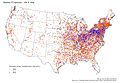
Namensbestandteile „Branch“ (violet), „Run“ (grün) oder „Brook“ (orange) bei fließenden Gewässern (feature class „stream“)
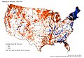
Namensbestandteile „lake“ (orange) oder „pond“ (blau) bei Seen (feature class „lake“)
Namensbestandteile „-ville“ (orange) oder „-burg“ (blau) bei bewohnten Orten (feature class „ppl“)
Andere Behörden zur Namensbestimmung geographischer Orte
- Das Bureau of the Census legt Census-designated places fest, die aus mehreren im GNIS genannten Örtlichkeiten bestehen können.
- Die U.S. Postal Service Publication 28 legt Standards für die Adressierung von Post fest. Dabei werden durch den Postal Service zweistellige Buchstabencodes festgelegt, die den Bundesstaat bezeichnen, sowie feste Abkürzungen für Straßen, wie etwa Boulevard (BLVD) und Street (ST) oder nachgeordnete Unterscheidungsmerkmale, wie etwa Suite (STE).
- Der Name der U.S. Postal Service Postämter wurde früher zur Bestimmung von Ortsnamen genutzt.
Namensänderungen
Vorschläge zur Änderung von Benennungen geographischer Objekte können an das GNIS gerichtet werden, wobei der Nachweis erbracht werden muss, dass der Vorschlag seine Berechtigung hat; die Vorlage von Unterstützerlisten ist dabei erforderlich.
Publikationen zum Thema
- U.S. Department of the Interior, U.S. Geological Survey, National Mapping Division, Digital Gazeteer: Users Manual, (Reston, Virginia: U.S. Geological Survey, 1994).
- Heat Moon, William Least, Blue Highways: A Journey Into America, (Boston: Little Brown and Company, 1982).
- Jouris, David, All Over The Map, (Berkeley, California: Ten Speed Press, 1994.).
- Report: "Countries, Dependencies, Areas Of Special Sovereignty, And Their Principal Administrative Divisions," Federal Information Processing Standards, FIPS 10-4.
- Report: "Principles, Policies, and Procedures: Domestic Geographic Names," U.S. Board of Geographic Names, 1997.
- U.S. Postal Service Publication 28, November 2000.
Siehe auch
- GEOnet Names Server, eine ähnliche Datenbank für Gebiete außerhalb der Vereinigten Staaten
- Geographical Names Board of Canada, eine ähnliche Einrichtung für Kanada
Weblinks
- Geographic Names Information System (englisch)
Einzelnachweise
- ↑ Annual Report To the Secretary of the Interior, Fiscal Year 2014. United States Board on Geographic Names (BGN), abgerufen am 29. Oktober 2015.
- ↑ Domestic Names – Frequently Asked Questions (FAQs) BGN
- ↑ Feature Class Definitions USGS
Auf dieser Seite verwendete Medien
.jpg)
Autor/Urheber: pfly from Pugetopolis, Lizenz: CC BY-SA 2.0
Place names of "populated places" (GNIS defined) that end in -ville and -burg(h).
.jpg)
Autor/Urheber: pfly from Pugetopolis, Lizenz: CC BY-SA 2.0
GNIS map Lake vs. Pond. The USGS GNIS placename database was used to make this map. Any body of water (GNIS's "lake" feature class) whose name ends in "Lake" gets an orange dot, and any whose name ends in "Pond" gets a blue dot. The map shows a tendency to use "pond" instead of "lake" in the New England region, with scattered uses of "pond" elsewhere, such as northern Florida. Source data, USGS GNIS placename database and ESRI's state boundary data.
Software, ESRI ArcGIS..jpg)
Autor/Urheber: pfly from Pugetopolis, Lizenz: CC BY-SA 2.0
The USGS GNIS placename database was used to make this map. Place names that end in "Coulee" are shown with an orange dot, while those ending in "Bayou" get a blue dot. The term "Coulee" has different meanings in different parts of the US, mostly unrelated to the term "Bayou"—except in Louisiana, where both terms refer to streams and drainage channels. Source data, USGS GNIS placename database and ESRI's state boundary data.
Software, ESRI ArcGIS..jpg)
Autor/Urheber: pfly from Pugetopolis, Lizenz: CC BY-SA 2.0
The USGS GNIS placename database was used to make this map. Any stream whose name ends in "Branch" gets a purple dot, any whose name ends in "Run" gets a green dot, and any whose name ends in "Brook" gets an orange dot. Stream names that end with other terms, like "River" or "Bayou" are not shown.
This map shows a strong geographic pattern in the use of these stream terms. "Brook" occurs mostly in New England and New York. "Run" is confined mainly to Pennsylvania, Ohio, and northern West Virginia. "Branch" is common in the South, including Missouri. Indiana, Maryland and Appalachian Virginia use both "Branch" and "Run". New Jersey uses all three terms. There are other curious patterns, such as a cluster of "Branches" in southwest Wisconsin and "Brooks" in Minnesota. All three terms are rare in the West.
Source data, USGS GNIS placename database and ESRI's state boundary data. Software, ESRI ArcGIS.