Alton (Staffordshire)
| Alton | ||
|---|---|---|
(c) Humphrey Bolton, CC BY-SA 2.0 | ||
| Koordinaten | 52° 59′ N, 1° 53′ W | |
| ||
| Traditionelle Grafschaft | Staffordshire | |
| Einwohner | 1226 | |
| Verwaltung | ||
| Postleitzahlenabschnitte | ST10 | |
| Landesteil | England | |
| Region | West Midlands | |
| Shire county | Staffordshire | |
Alton ist ein Dorf in Staffordshire, England.[1] Es ist bekannt für den Themenpark Alton Towers, der um das Gelände des Alton Mansion herum gebaut wurde, das den Earls of Shrewsbury gehörte[2] und von Augustus Pugin entworfen wurde.[3] In der Karte von 1914 von Whiston gab es im Dorf Kupferwerke.[1]
Das Dorf liegt auf der Ostseite des River Churnet.[4] Es wird im Domesday Book erwähnt und enthält zahlreiche Gebäude von architektonischem Interesse; das Round-House, Alton Castle (jetzt ein katholisches Jugendzentrum für Exerzitien), die St. Peter’s Church, das Malt House, die St. John’s Church und Alton Towers.[5]
Alton war an den Bahnhof Alton angebunden, der am 13. Juli 1849 von der North Staffordshire Railway eröffnet und im Januar 1965 geschlossen wurde.[3]
The Chained Oak in Alton wurde durch die Fahrt Hex – The Legend of the Towers in Alton Towers und die Legende um den Earl of Shrewsbury berühmt.[6]
Weblinks
- Informationen von Saint Peter’s
- Geschichte Altons. Alton in Staffordshire, archiviert vom am 7. Januar 2008; abgerufen am 29. November 2007.
- Fotos von Alton
Einzelnachweise
- ↑ a b Roger J. P. Kain, John Chapman, Richard R. Oliver: The Enclosure Maps of England and Wales 1595–1918: A Cartographic Analysis and Electronic Catalogue. Cambridge University Press, 2004, ISBN 978-0-521-82771-3, S. 118–.
- ↑ William West, Frederick Calvert: Picturesque views and description of cities, towns, castles, mansions, and other objects of interesting feature, in Staffordshire, from original designs, taken expressly for this work by Frederick Calvert, engraved on steel dy Mr. T. Radclyffe, with historical and topographical illustrations. William Emans, 1834, S. 28–.
- ↑ a b Peter Scott: A History of the Alton Towers Railway: Including Other Railways & Transport Systems at Alton Towers, Together with the Railways at Lilleshall Hall & Trentham Gardens. Peter Scott, 1998, ISBN 978-1-902368-06-1, S. 11–.
- ↑ William Adam: The Gem of the Peak; or Matlock Bath and its vicinity; an account of Derby; a tour from Derby to Matlock: ... a review of the geology of Derbyshire; catalogue of minerals and rocks, and of the flora of the high and low Peak. J. & C. Mozley, 1857, S. 238– (google.com [abgerufen am 28. September 2012]).
- ↑ H. C. Darby, I. B. Terrett: The Domesday Geography of Midland England. Cambridge University Press, 1971, ISBN 978-0-521-08078-1, S. 320–.
- ↑ Steve Hollyman and Gary Kelsall: The Legend of the Chained Oak. Alton Towers Heritage, 2008, archiviert vom am 30. April 2013; abgerufen am 28. September 2012.
Auf dieser Seite verwendete Medien
(c) Karte: NordNordWest, Lizenz: Creative Commons by-sa-3.0 de
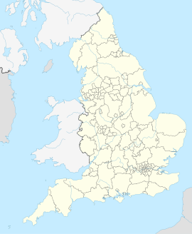
Positionskarte von England, Vereinigtes Königreich
(c) Humphrey Bolton, CC BY-SA 2.0
High Street and the Black Bull, Alton The Black Bull seemed to be the only place in Alton serving lunches on a November weekday, and we enjoyed it enough to come back the next day.
(c) Humphrey Bolton, CC BY-SA 2.0
The village sign, Alton The name is spelt out in a colourful mosaic.


